STS094-721-45

| NASA Photo ID | STS094-721-45 |
| Focal Length | 250mm |
| Date taken | 1997.07.07 |
| Time taken | 17:22:09 GMT |

Cloud masks available for this image:
Spacecraft nadir point: 19.6° N, 70.8° W
Photo center point: 18.5° N, 71.0° W
Photo center point by machine learning:
Photo center point: 18.5° N, 71.0° W
Photo center point by machine learning:
Nadir to Photo Center: South
Spacecraft Altitude: 160 nautical miles (296km)
Camera: | Hasselblad |
Focal Length: | 250mm |
Camera Tilt: | 23 degrees |
Format: | 5069: Kodak Elite 100S, E6 Reversal, Replaces Lumiere, Warmer in tone vs. Lumiere |
Film Exposure: | Normal |
| Additional Information | |
| Width | Height | Annotated | Cropped | Purpose | Links |
|---|---|---|---|---|---|
| 4096 pixels | 4096 pixels | No | No | Earth From Space collection | Download Image |
| 640 pixels | 640 pixels | No | No | Earth From Space collection | Download Image |
| 506 pixels | 514 pixels | No | No | Download Image |
Download Packaged File
Download a Google Earth KML for this Image
View photo footprint information
Download a GeoTIFF for this photo
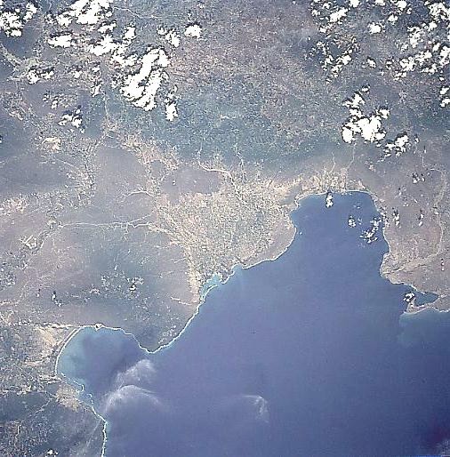
Image Caption: STS094-721-045 Oacha/Neiba Bays, Dominican Republic July 1997
A portion of the southwestern coast of the Dominican Republic can be seen in this northeast-looking view. Two bays are visible in this view: 1) Oacha Bay at the right center of the image, and 2) Neiba Bay toward the bottom left of the image. The growing city of Barahona is discernible on the southern coast of Neiba Bay. Because of the area's fine beaches and relative quite as compared to the bigger cities in the Dominican Republic, tourism is a rapidly growing industry in this part of the country. Geologically, Neiba Bay is the eastern end of a rift valley that extends westward past Lake Enriquillo to the city of Port-Au-Prince in Haiti. The high-forested mountains of the Central Cordillera are visible in the upper right portion of the image. Point Salina is visible just below the right center of the image.
A portion of the southwestern coast of the Dominican Republic can be seen in this northeast-looking view. Two bays are visible in this view: 1) Oacha Bay at the right center of the image, and 2) Neiba Bay toward the bottom left of the image. The growing city of Barahona is discernible on the southern coast of Neiba Bay. Because of the area's fine beaches and relative quite as compared to the bigger cities in the Dominican Republic, tourism is a rapidly growing industry in this part of the country. Geologically, Neiba Bay is the eastern end of a rift valley that extends westward past Lake Enriquillo to the city of Port-Au-Prince in Haiti. The high-forested mountains of the Central Cordillera are visible in the upper right portion of the image. Point Salina is visible just below the right center of the image.
