STS094-718-7
| NASA Photo ID | STS094-718-7 |
| Focal Length | 100mm |
| Date taken | 1997.07.09 |
| Time taken | 07:15:33 GMT |

Cloud masks available for this image:
Spacecraft nadir point: 6.5° S, 120.4° E
Photo center point: 8.0° S, 119.0° E
Photo center point by machine learning:
Photo center point: 8.0° S, 119.0° E
Photo center point by machine learning:
Nadir to Photo Center: Southwest
Spacecraft Altitude: 163 nautical miles (302km)
Country or Geographic Name: | INDONESIA |
Features: | SANGEANG ISLAND, SMOKE |
| Features Found Using Machine Learning: | |
Cloud Cover Percentage: | 5 (1-10)% |
Sun Elevation Angle: | 35° |
Sun Azimuth: | 303° |
Camera: | Hasselblad |
Focal Length: | 100mm |
Camera Tilt: | 37 degrees |
Format: | 5069: Kodak Elite 100S, E6 Reversal, Replaces Lumiere, Warmer in tone vs. Lumiere |
Film Exposure: | Normal |
| Additional Information | |
| Width | Height | Annotated | Cropped | Purpose | Links |
|---|---|---|---|---|---|
| 4050 pixels | 3984 pixels | No | No | Earth From Space collection | Download Image |
| 640 pixels | 629 pixels | No | No | Earth From Space collection | Download Image |
| 1247 pixels | 1263 pixels | Download Image |
Download Packaged File
Download a Google Earth KML for this Image
View photo footprint information
Download a GeoTIFF for this photo
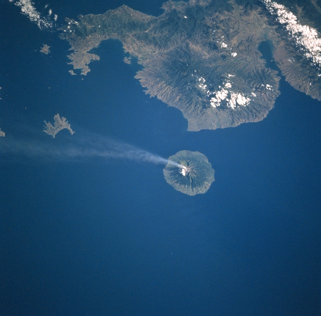
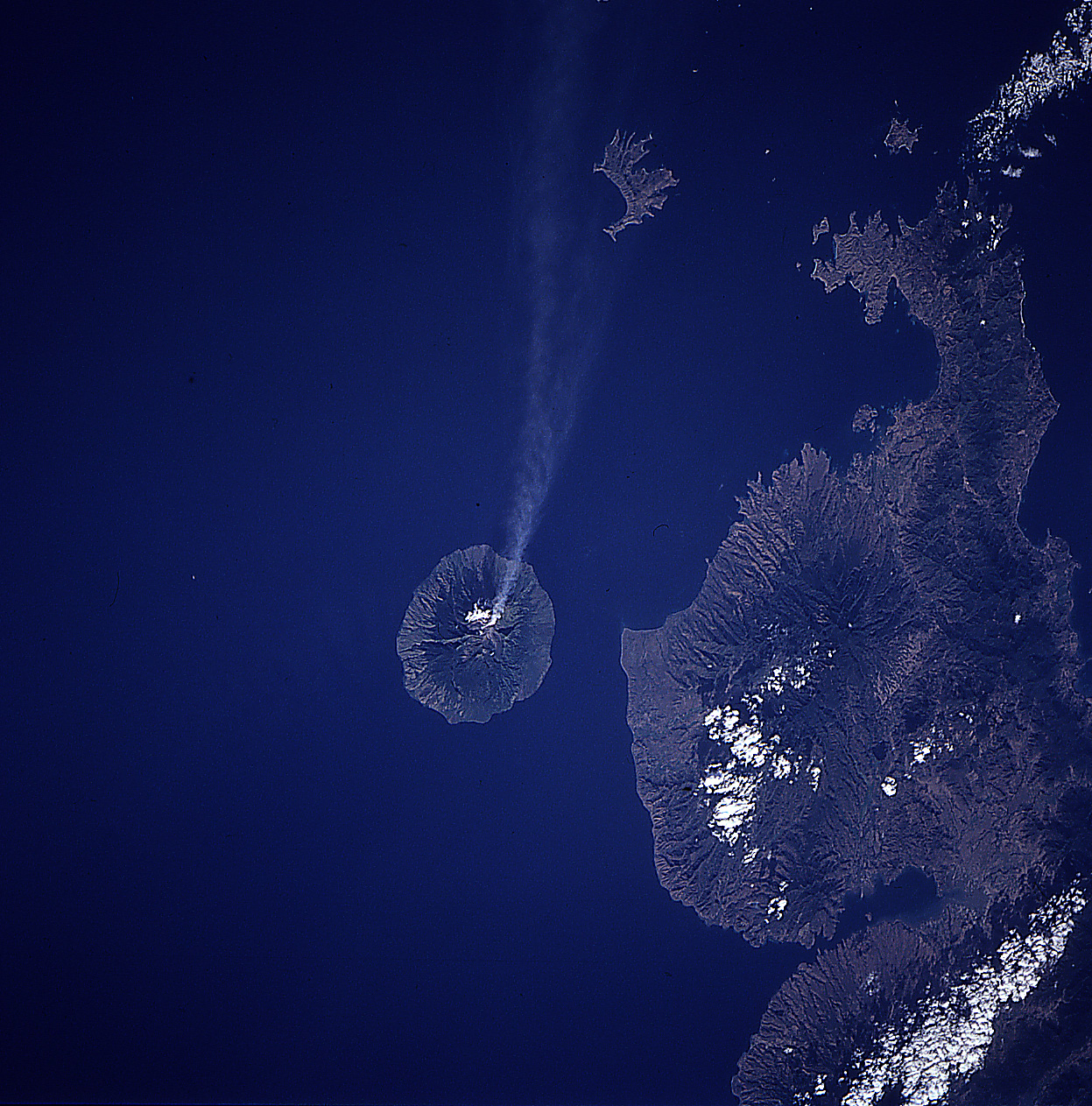
Image Caption: STS094-718-007 Sangeang Island, Api Volcano, Indonesia July 1997
This southwest-looking view shows the Indonesian island of Sangeang, and a smoke cloud blowing in a southeasterly direction from Api Volcano. Sangeang is an 8-mile (13 km) wide island that is located off the northeast coast of Sumbawa Island (top of image). Api is one of the most active volcanoes in the Lesser Sunda Islands. The volcano is made up of two volcanic cones, the highest being Mount Dori at 6393 feet (1949 meters) above sea level. Intermittent historical eruptions of Api Volcano have been recorded since 1512, but most occurred during the 20th Century. To the left (southeast) of Sangeang Island is Banta Island, the remains of a former volcano. Though partially cloud covered, the Sape Strait is discernible in the upper left corner of the image. Bima Bay on the island of Sumbawa is visible in the upper right portion of the image.
This southwest-looking view shows the Indonesian island of Sangeang, and a smoke cloud blowing in a southeasterly direction from Api Volcano. Sangeang is an 8-mile (13 km) wide island that is located off the northeast coast of Sumbawa Island (top of image). Api is one of the most active volcanoes in the Lesser Sunda Islands. The volcano is made up of two volcanic cones, the highest being Mount Dori at 6393 feet (1949 meters) above sea level. Intermittent historical eruptions of Api Volcano have been recorded since 1512, but most occurred during the 20th Century. To the left (southeast) of Sangeang Island is Banta Island, the remains of a former volcano. Though partially cloud covered, the Sape Strait is discernible in the upper left corner of the image. Bima Bay on the island of Sumbawa is visible in the upper right portion of the image.
