STS092-703-77

| NASA Photo ID | STS092-703-77 |
| Focal Length | 40mm |
| Date taken | 2000.10.16 |
| Time taken | 23:24:09 GMT |
Resolutions offered for this image:
1031 x 1024 pixels 2063 x 2048 pixels 4127 x 4096 pixels 515 x 512 pixels 1309 x 1293 pixels 400 x 405 pixels
1031 x 1024 pixels 2063 x 2048 pixels 4127 x 4096 pixels 515 x 512 pixels 1309 x 1293 pixels 400 x 405 pixels


Cloud masks available for this image:
Spacecraft nadir point: 42.5° S, 176.6° E
Photo center point: 40.0° S, 176.0° E
Photo center point by machine learning:
Photo center point: 40.0° S, 176.0° E
Photo center point by machine learning:
Nadir to Photo Center: North
Spacecraft Altitude: 207 nautical miles (383km)
Country or Geographic Name: | NEW ZEALAND-NI |
Features: | PAN-ENTIRE ISLAND |
| Features Found Using Machine Learning: | |
Cloud Cover Percentage: | 25 (11-25)% |
Sun Elevation Angle: | 56° |
Sun Azimuth: | 16° |
Camera: | Hasselblad |
Focal Length: | 40mm |
Camera Tilt: | High Oblique |
Format: | 5069: Kodak Elite 100S, E6 Reversal, Replaces Lumiere, Warmer in tone vs. Lumiere |
Film Exposure: | |
| Additional Information | |
| Width | Height | Annotated | Cropped | Purpose | Links |
|---|---|---|---|---|---|
| 1031 pixels | 1024 pixels | No | No | Download Image | |
| 2063 pixels | 2048 pixels | No | No | Download Image | |
| 4127 pixels | 4096 pixels | No | No | Download Image | |
| 515 pixels | 512 pixels | No | No | Download Image | |
| 1309 pixels | 1293 pixels | No | No | Download Image | |
| 400 pixels | 405 pixels | Download Image |
Download Packaged File
Download a Google Earth KML for this Image
View photo footprint information
Download a GeoTIFF for this photo
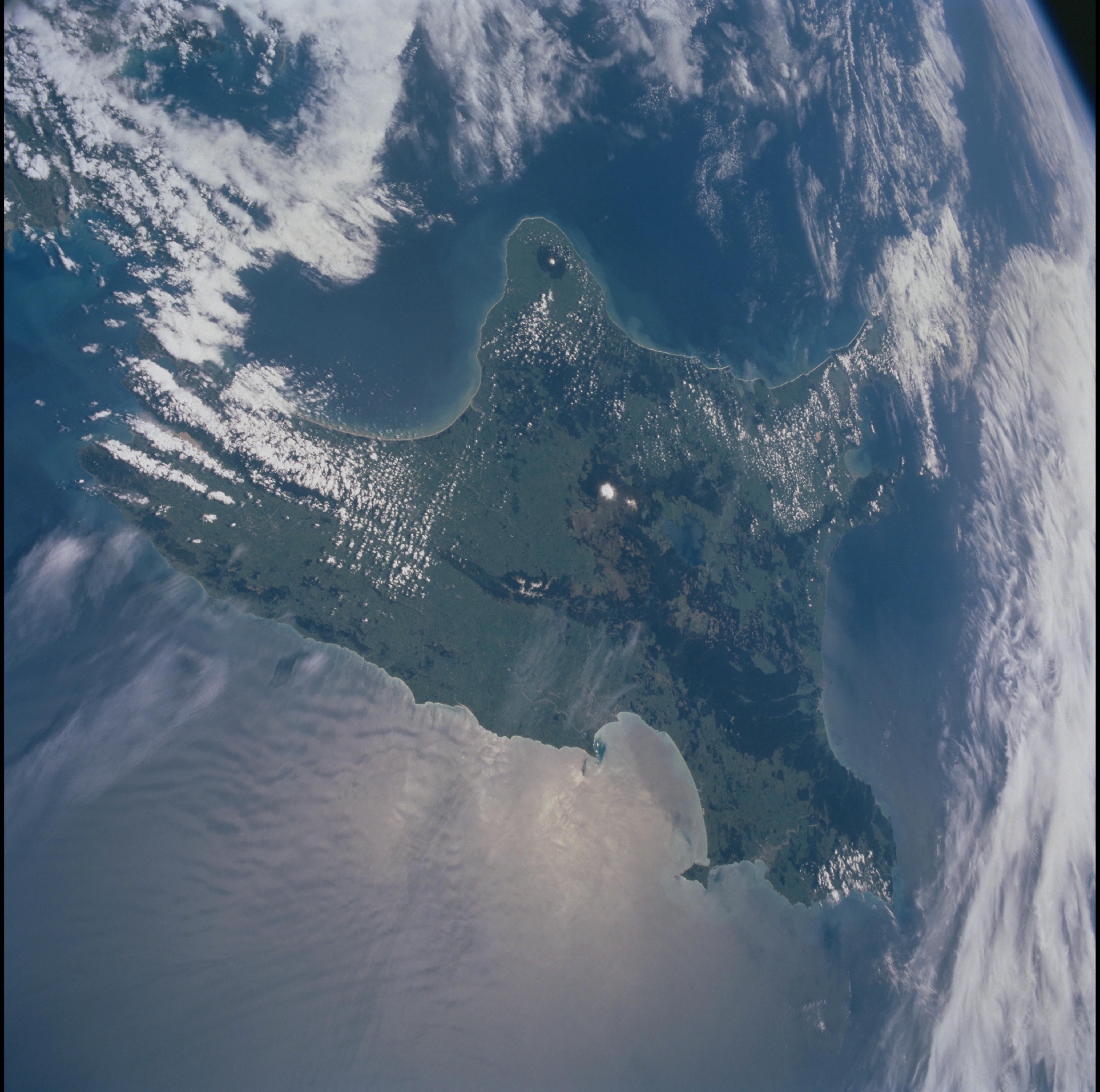
Image Caption: North Island, New Zealand
Ruapehu (snowy peak) and Tongariro are active volcanoes that line along
a northeasterly line through North Island, New Zealand; White Island
(with plume) in the Bay of Plenty is the northernmost subaerial volcano
of the line. As the Pacific plate descends beneath the eastern edge of
North Island, the crust of the overriding Australian/Indian plate is
stretched. Lava rises through the weakened crust and the line of active
volcanoes develops. Geothermal energy from volcanic heat is used to
generate power for North Island.
