STS092-316-12
| NASA Photo ID | STS092-316-12 |
| Focal Length | mm |
| Date taken | 2000.10.24 |
| Time taken | 16:05:44 GMT |
Resolutions offered for this image:
540 x 355 pixels 3070 x 2044 pixels 515 x 342 pixels 2964 x 1976 pixels 3398 x 2190 pixels 540 x 421 pixels 909 x 709 pixels 868 x 593 pixels
540 x 355 pixels 3070 x 2044 pixels 515 x 342 pixels 2964 x 1976 pixels 3398 x 2190 pixels 540 x 421 pixels 909 x 709 pixels 868 x 593 pixels


Cloud masks available for this image:
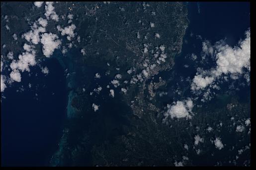
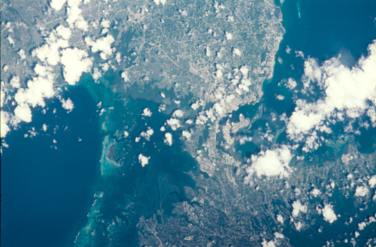
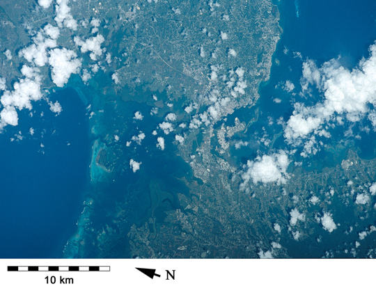
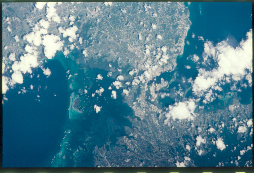
Spacecraft nadir point: 16.3° N, 60.6° W
Photo center point: 16.5° N, 61.5° W
Photo center point by machine learning:
Photo center point: 16.5° N, 61.5° W
Photo center point by machine learning:
Nadir to Photo Center: West
Spacecraft Altitude: 204 nautical miles (378km)
Country or Geographic Name: | LESSER ANTILLES |
Features: | GUADELOUPE |
| Features Found Using Machine Learning: | |
Cloud Cover Percentage: | 25 (11-25)% |
Sun Elevation Angle: | 61° |
Sun Azimuth: | 190° |
Camera: | Nikon 35mm film camera |
Focal Length: | mm |
Camera Tilt: | 15 degrees |
Format: | 5069: Kodak Elite 100S, E6 Reversal, Replaces Lumiere, Warmer in tone vs. Lumiere |
Film Exposure: | |
| Additional Information | |
| Width | Height | Annotated | Cropped | Purpose | Links |
|---|---|---|---|---|---|
| 540 pixels | 355 pixels | Photographic Highlights | Download Image | ||
| 3070 pixels | 2044 pixels | No | No | Download Image | |
| 515 pixels | 342 pixels | No | No | Download Image | |
| 2964 pixels | 1976 pixels | No | No | Download Image | |
| 3398 pixels | 2190 pixels | No | No | Download Image | |
| 540 pixels | 421 pixels | Yes | Yes | Publisher Request | Download Image |
| 909 pixels | 709 pixels | Yes | Yes | Publisher Request | Download Image |
| 868 pixels | 593 pixels | No | No | Download Image |
Download Packaged File
Download a Google Earth KML for this Image
View photo footprint information
Download a GeoTIFF for this photo
Image Caption: The Grand Cul-de-Sac Marin in Guadeloupe hasi mportant mangrove, seagrass and patch and barrier reef communities [STS092-316-12, 2000].
