STS091-729-4
| NASA Photo ID | STS091-729-4 |
| Focal Length | 250mm |
| Date taken | 1998.06.07 |
| Time taken | 14:52:40 GMT |

Cloud masks available for this image:
Spacecraft nadir point: 44.0° S, 73.2° W
Photo center point: 48.0° S, 75.0° W
Photo center point by machine learning:
Photo center point: 48.0° S, 75.0° W
Photo center point by machine learning:
Nadir to Photo Center: South
Spacecraft Altitude: 206 nautical miles (382km)
Country or Geographic Name: | CHILE |
Features: | CAMPANA ISLAND, PRAT I. |
| Features Found Using Machine Learning: | |
Cloud Cover Percentage: | 5 (1-10)% |
Sun Elevation Angle: | 18° |
Sun Azimuth: | 29° |
Camera: | Hasselblad |
Focal Length: | 250mm |
Camera Tilt: | 52 degrees |
Format: | 5069: Kodak Elite 100S, E6 Reversal, Replaces Lumiere, Warmer in tone vs. Lumiere |
Film Exposure: | Normal |
| Additional Information | |
| Width | Height | Annotated | Cropped | Purpose | Links |
|---|---|---|---|---|---|
| 4072 pixels | 4096 pixels | No | No | Earth From Space collection | Download Image |
| 636 pixels | 640 pixels | No | No | Earth From Space collection | Download Image |
Download Packaged File
Download a Google Earth KML for this Image
View photo footprint information
Download a GeoTIFF for this photo
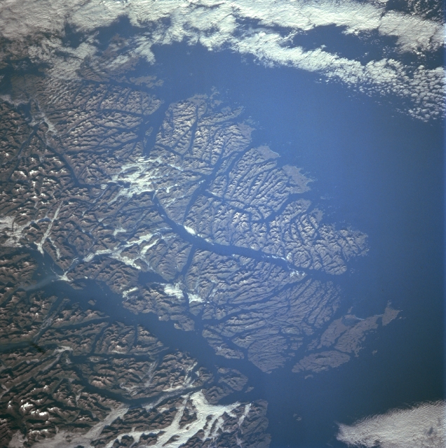
Image Caption: STS091-729-004 Guayaneco Archipelago, Chile June 1998
The islands of the Guayaneco Archipelago can be seen in this southwest-looking view. The Guayaneco Archipelago was heavily glaciated during the most recent ice age. These glaciers dissected these mountain islands into a series of deep river valleys and glacial troughs. Today these glacial troughs are deep channels and fjords. The islands of the Guayaneco Archipelago comprise a series of elongated islands and deep bays that are the traces of a drowned coastal range. A number of deep channels are visible traversing generally north to south through the islands. These include the Messier Channel in the lower left portion of the image, and the Fallos Channel near the center of the image. The Pacific Ocean covers most of the upper center and upper right portion of the image. Forests cover the lower slopes of the mountains throughout the many islands. Human settlement on these islands is scarce.
The islands of the Guayaneco Archipelago can be seen in this southwest-looking view. The Guayaneco Archipelago was heavily glaciated during the most recent ice age. These glaciers dissected these mountain islands into a series of deep river valleys and glacial troughs. Today these glacial troughs are deep channels and fjords. The islands of the Guayaneco Archipelago comprise a series of elongated islands and deep bays that are the traces of a drowned coastal range. A number of deep channels are visible traversing generally north to south through the islands. These include the Messier Channel in the lower left portion of the image, and the Fallos Channel near the center of the image. The Pacific Ocean covers most of the upper center and upper right portion of the image. Forests cover the lower slopes of the mountains throughout the many islands. Human settlement on these islands is scarce.
