STS091-702-23
| NASA Photo ID | STS091-702-23 |
| Focal Length | 250mm |
| Date taken | 1998.06.05 |
| Time taken | 09:37:55 GMT |

Cloud masks available for this image:
Spacecraft nadir point: 25.2° N, 90.0° E
Photo center point: 24.0° N, 89.0° E
Photo center point by machine learning:
Photo center point: 24.0° N, 89.0° E
Photo center point by machine learning:
Nadir to Photo Center: Southwest
Spacecraft Altitude: 199 nautical miles (369km)
Country or Geographic Name: | BANGLADESH |
Features: | GANGES RIVER |
| Features Found Using Machine Learning: | |
Cloud Cover Percentage: | 5 (1-10)% |
Sun Elevation Angle: | 40° |
Sun Azimuth: | 279° |
Camera: | Hasselblad |
Focal Length: | 250mm |
Camera Tilt: | 25 degrees |
Format: | 5069: Kodak Elite 100S, E6 Reversal, Replaces Lumiere, Warmer in tone vs. Lumiere |
Film Exposure: | Over Exposed |
| Additional Information | |
| Width | Height | Annotated | Cropped | Purpose | Links |
|---|---|---|---|---|---|
| 4096 pixels | 4096 pixels | No | No | Earth From Space collection | Download Image |
| 640 pixels | 640 pixels | No | No | Earth From Space collection | Download Image |
| 644 pixels | 628 pixels | No | No | Download Image |
Download Packaged File
Download a Google Earth KML for this Image
View photo footprint information
Download a GeoTIFF for this photo
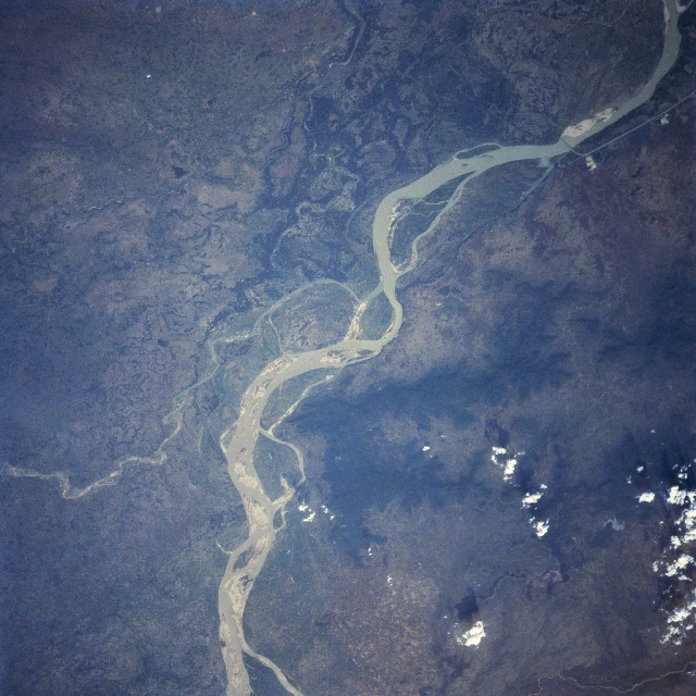
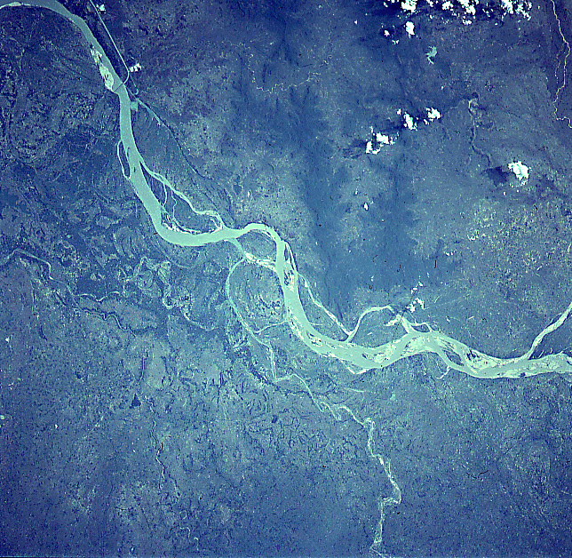
Image Caption: STS091-702-023 Ganges River, India June 1998
A small section of the meandering Ganges River (ribbon-like, light-colored feature), the major river of the Indian subcontinent, skirts along the northern edge of the Rajmahal Hills (darker landscape, bottom center). These brownish-looking, vegetated hills rise between 500 feet (150 meters) to over 1000 feet (300 meters) above the surrounding plains. The Hindu people believe that the Ganges River is the most sacred river in the world. The river's broad floodplain contains many interconnected channels. The south draining, meandering Mahananda River (smaller, light-colored line-bottom left) converges with the main channel of the Ganges near the center of the image. Downstream from the confluence of these two rivers a railroad bridge (straight line crossing the Ganges) and a drainage canal (thin, straight, light-colored line) can be identified. The bridge crossing is located approximately 5 miles (8 km) northwest of the Indian-Bangladesh border.
A small section of the meandering Ganges River (ribbon-like, light-colored feature), the major river of the Indian subcontinent, skirts along the northern edge of the Rajmahal Hills (darker landscape, bottom center). These brownish-looking, vegetated hills rise between 500 feet (150 meters) to over 1000 feet (300 meters) above the surrounding plains. The Hindu people believe that the Ganges River is the most sacred river in the world. The river's broad floodplain contains many interconnected channels. The south draining, meandering Mahananda River (smaller, light-colored line-bottom left) converges with the main channel of the Ganges near the center of the image. Downstream from the confluence of these two rivers a railroad bridge (straight line crossing the Ganges) and a drainage canal (thin, straight, light-colored line) can be identified. The bridge crossing is located approximately 5 miles (8 km) northwest of the Indian-Bangladesh border.
