STS090-750-95
| NASA Photo ID | STS090-750-95 |
| Focal Length | 250mm |
| Date taken | 1998.05.02 |
| Time taken | 16:02:15 GMT |
Resolutions offered for this image:
4049 x 4091 pixels 633 x 640 pixels 516 x 512 pixels 479 x 478 pixels 516 x 512 pixels
4049 x 4091 pixels 633 x 640 pixels 516 x 512 pixels 479 x 478 pixels 516 x 512 pixels


Cloud masks available for this image:
Spacecraft nadir point: 33.9° N, 77.4° W
Photo center point: 34.5° N, 76.5° W
Photo center point by machine learning:
Photo center point: 34.5° N, 76.5° W
Photo center point by machine learning:
Nadir to Photo Center: Northeast
Spacecraft Altitude: 131 nautical miles (243km)
Country or Geographic Name: | USA-NORTH CAROLINA |
Features: | CAPE LOOKOUT, NEUSE RIVER |
| Features Found Using Machine Learning: | |
Cloud Cover Percentage: | 5 (1-10)% |
Sun Elevation Angle: | 67° |
Sun Azimuth: | 138° |
Camera: | Hasselblad |
Focal Length: | 250mm |
Camera Tilt: | 26 degrees |
Format: | 5069: Kodak Elite 100S, E6 Reversal, Replaces Lumiere, Warmer in tone vs. Lumiere |
Film Exposure: | Normal |
| Additional Information | |
| Width | Height | Annotated | Cropped | Purpose | Links |
|---|---|---|---|---|---|
| 4049 pixels | 4091 pixels | No | No | Earth From Space collection | Download Image |
| 633 pixels | 640 pixels | No | No | Earth From Space collection | Download Image |
| 516 pixels | 512 pixels | Earth From Space phase 2 | Download Image | ||
| 479 pixels | 478 pixels | Download Image | |||
| 516 pixels | 512 pixels | No | No | Download Image |
Download Packaged File
Download a Google Earth KML for this Image
View photo footprint information
Download a GeoTIFF for this photo
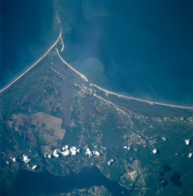
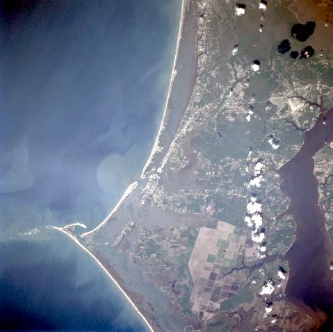
Image Caption: STS090-750-095 Morehead City, Cape lookout, North Carolina April, 1998
Cape Lookout and the southern portions of the Cape Lookout National Seashore, and the Crystal Coast to the west of Cape Lookout, can be seen in this west-looking view. Two of the three barrier islands of the Cape Lookout National Seashore, South Core Banks on which Cape Lookout is visible, and Shackleford Banks, the barrier island just to the west or right of Cape Lookout, are visible. The total Cape Lookout National Seashore is 55 miles (89 km) long and consist of three low, narrow, sand islands. The islands are wide beaches with low sand dunes covered by scattered grasses. Somewhat inland off the Atlantic Ocean beaches, the island consists of flat grasslands bordered by dense vegetation and large expanse of salt marshes along side the inland sounds. Winds, waves, and currents continually are at work reshaping the barrier islands. Morehead City is discernible near the center of the image. Morehead City is one of two deep-water ports in North Carolina. Tourism, fishing, and boat building are the major economic activities of the city. Along the right center to the bottom right of the image, the Neuse River Estuary can be seen. The Crystal Coast area of North Carolina is visible beginning at Morehead City and extending westward to the upper right portion of the image. The largest of the four lakes discernible in the upper right portion of the image is Great Lake. These lakes are situated in the Croatan National Forest.
Cape Lookout and the southern portions of the Cape Lookout National Seashore, and the Crystal Coast to the west of Cape Lookout, can be seen in this west-looking view. Two of the three barrier islands of the Cape Lookout National Seashore, South Core Banks on which Cape Lookout is visible, and Shackleford Banks, the barrier island just to the west or right of Cape Lookout, are visible. The total Cape Lookout National Seashore is 55 miles (89 km) long and consist of three low, narrow, sand islands. The islands are wide beaches with low sand dunes covered by scattered grasses. Somewhat inland off the Atlantic Ocean beaches, the island consists of flat grasslands bordered by dense vegetation and large expanse of salt marshes along side the inland sounds. Winds, waves, and currents continually are at work reshaping the barrier islands. Morehead City is discernible near the center of the image. Morehead City is one of two deep-water ports in North Carolina. Tourism, fishing, and boat building are the major economic activities of the city. Along the right center to the bottom right of the image, the Neuse River Estuary can be seen. The Crystal Coast area of North Carolina is visible beginning at Morehead City and extending westward to the upper right portion of the image. The largest of the four lakes discernible in the upper right portion of the image is Great Lake. These lakes are situated in the Croatan National Forest.
