STS089-709-56

| NASA Photo ID | STS089-709-56 |
| Focal Length | 100mm |
| Date taken | 1998.01.30 |
| Time taken | 18:30:12 GMT |
Cloud masks available for this image:
Spacecraft nadir point: 33.3° S, 57.4° W
Photo center point: 35.0° S, 57.0° W
Photo center point by machine learning:
Photo center point: 35.0° S, 57.0° W
Photo center point by machine learning:
Nadir to Photo Center: South
Spacecraft Altitude: 197 nautical miles (365km)
Country or Geographic Name: | ARGENTINA |
Features: | PLATA RIVER |
| Features Found Using Machine Learning: | |
Cloud Cover Percentage: | 5 (1-10)% |
Sun Elevation Angle: | 54° |
Sun Azimuth: | 286° |
Camera: | Hasselblad |
Focal Length: | 100mm |
Camera Tilt: | 28 degrees |
Format: | 5069: Kodak Elite 100S, E6 Reversal, Replaces Lumiere, Warmer in tone vs. Lumiere |
Film Exposure: | Normal |
| Additional Information | |
| Width | Height | Annotated | Cropped | Purpose | Links |
|---|---|---|---|---|---|
| 4096 pixels | 4096 pixels | No | No | Earth From Space collection | Download Image |
| 640 pixels | 640 pixels | No | No | Earth From Space collection | Download Image |
Download Packaged File
Download a Google Earth KML for this Image
View photo footprint information
Download a GeoTIFF for this photo
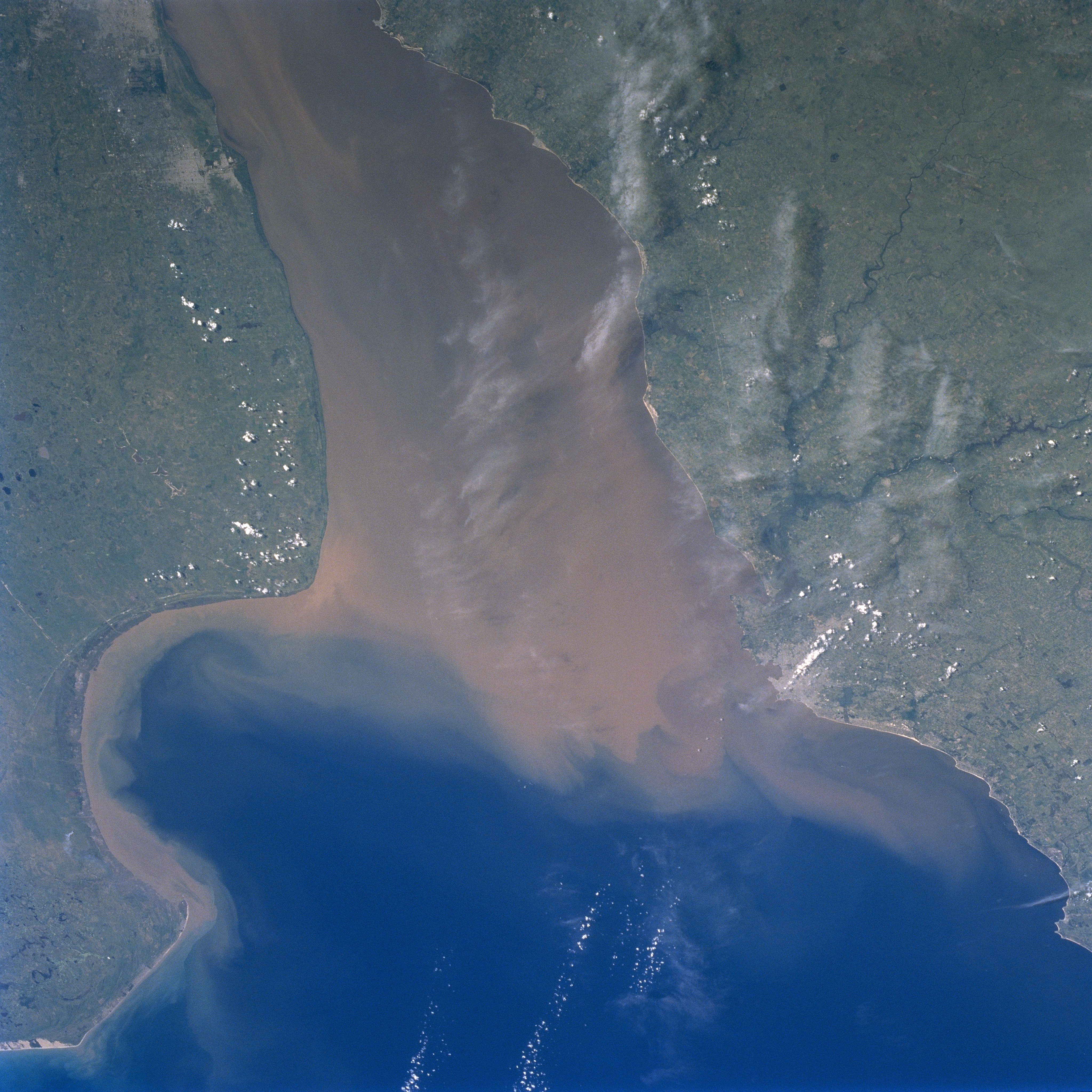
Image Caption: STS089-709-056 Rio de la Plata, Uruguay January 1998
Although clouds obscure parts of the picture, the Rio de la Plata (a large estuary) is located between Argentina (south) and Uruguay (north). The estuary of the Rio de la Plata is one of the largest in the world. It receives runoff from five South American countries (Argentina, Uruguay, Brazil, Paraguay, and Bolivia). The extensive sediment plume (muddy looking water) in the Rio de la Plata seems to be a normal condition of the river. There is a constant mixing zone where the sediment-laden fresh water meets the salty waters of the southern Atlantic Ocean. Notice how a narrow band of sediment is hugging the U-shaped shoreline of the Argentina coast. The cluster of lighter colored areas near the top left corner of the image indicates the location of the city of La Plata and the eastern edge of the Argentine capital of Buenos Aires. The general location of the capital and largest city in Uruguay, Montevideo, can be identified along the northern shore of the estuary. The Santa Lucia River (dark, dendritic stream pattern) enters the Rio de la Plata just west of Montevideo.
Although clouds obscure parts of the picture, the Rio de la Plata (a large estuary) is located between Argentina (south) and Uruguay (north). The estuary of the Rio de la Plata is one of the largest in the world. It receives runoff from five South American countries (Argentina, Uruguay, Brazil, Paraguay, and Bolivia). The extensive sediment plume (muddy looking water) in the Rio de la Plata seems to be a normal condition of the river. There is a constant mixing zone where the sediment-laden fresh water meets the salty waters of the southern Atlantic Ocean. Notice how a narrow band of sediment is hugging the U-shaped shoreline of the Argentina coast. The cluster of lighter colored areas near the top left corner of the image indicates the location of the city of La Plata and the eastern edge of the Argentine capital of Buenos Aires. The general location of the capital and largest city in Uruguay, Montevideo, can be identified along the northern shore of the estuary. The Santa Lucia River (dark, dendritic stream pattern) enters the Rio de la Plata just west of Montevideo.
