STS085-713-70
| NASA Photo ID | STS085-713-70 |
| Focal Length | 100mm |
| Date taken | 1997.08.12 |
| Time taken | 15:25:13 GMT |
Resolutions offered for this image:
4074 x 4096 pixels 636 x 640 pixels 5700 x 5900 pixels 483 x 500 pixels 502 x 515 pixels 479 x 479 pixels
4074 x 4096 pixels 636 x 640 pixels 5700 x 5900 pixels 483 x 500 pixels 502 x 515 pixels 479 x 479 pixels


Cloud masks available for this image:
Spacecraft nadir point: 54.4° N, 74.7° W
Photo center point: 53.0° N, 81.0° W
Photo center point by machine learning:
Photo center point: 53.0° N, 81.0° W
Photo center point by machine learning:
Nadir to Photo Center: West
Spacecraft Altitude: 156 nautical miles (289km)
Country or Geographic Name: | CANADA-O |
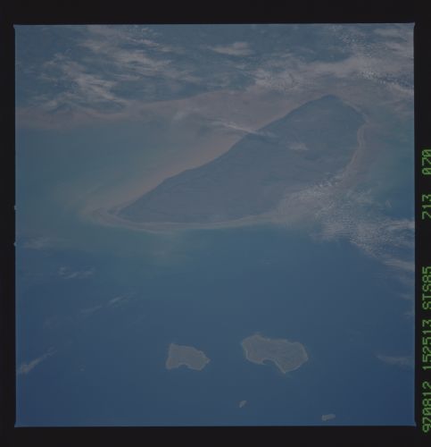
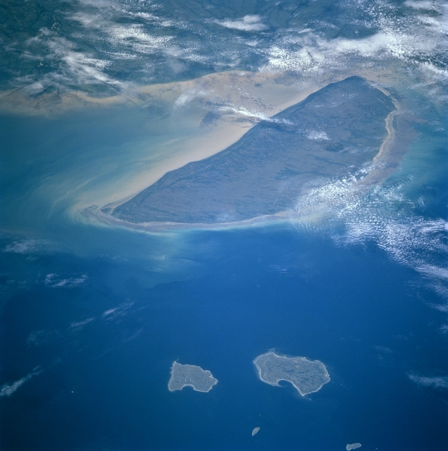
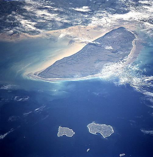
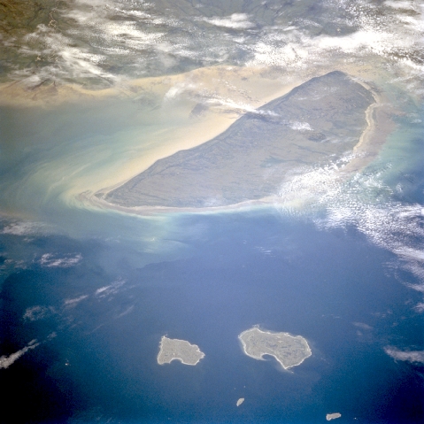
Features: | AKIMISKI ISLAND |
| Features Found Using Machine Learning: | |
Cloud Cover Percentage: | 25 (11-25)% |
Sun Elevation Angle: | 46° |
Sun Azimuth: | 144° |
Camera: | Hasselblad |
Focal Length: | 100mm |
Camera Tilt: | Low Oblique |
Format: | 5069: Kodak Elite 100S, E6 Reversal, Replaces Lumiere, Warmer in tone vs. Lumiere |
Film Exposure: | Normal |
| Additional Information | |
| Width | Height | Annotated | Cropped | Purpose | Links |
|---|---|---|---|---|---|
| 4074 pixels | 4096 pixels | No | No | Earth From Space collection | Download Image |
| 636 pixels | 640 pixels | No | No | Earth From Space collection | Download Image |
| 5700 pixels | 5900 pixels | No | No | Download Image | |
| 483 pixels | 500 pixels | No | No | Download Image | |
| 502 pixels | 515 pixels | No | No | Download Image | |
| 479 pixels | 479 pixels | Download Image |
Download Packaged File
Download a Google Earth KML for this Image
View photo footprint information
Download a GeoTIFF for this photo
Image Caption: STS085-713-070 Akimiski Island, Northwest Territory, Canada August 1997 Akimiski Island, a 2000-square-mile (5180 square kilometers) uninhabited island, is the largest island in James Bay (a southeasterly extension of Hudson Bay). The surface of the island is flat and slopes gradually to the north. Most of the vegetation that covers the island consists of lichens, moss, sage grasses, and dwarf black spruce trees. The eastern half of the island is a migratory bird sanctuary. The island is a coastal wetland that includes mud flats, tidal marshes, and tidal mud flats. Fresh-water streams that flow into southwestern James Bay carry sediments and abundant nutrients that help to sustain the productive waterfowl habitat around Akimiski Island. Lighter areas above the center of the view are sediment-laden brackish waters along the bayshore and south coast of the island. North and South Twin Islands are near the bottom of the picture.
