STS085-508-24
| NASA Photo ID | STS085-508-24 |
| Focal Length | 250mm |
| Date taken | 1997.08.17 |
| Time taken | 18:59:04 GMT |
Resolutions offered for this image:
5248 x 4096 pixels 640 x 499 pixels 1119 x 883 pixels 479 x 380 pixels 608 x 480 pixels
5248 x 4096 pixels 640 x 499 pixels 1119 x 883 pixels 479 x 380 pixels 608 x 480 pixels

Cloud masks available for this image:
Spacecraft nadir point: 39.7° N, 74.0° W
Photo center point: 40.0° N, 74.5° W
Photo center point by machine learning:
Photo center point: 40.0° N, 74.5° W
Photo center point by machine learning:
Nadir to Photo Center: Northwest
Spacecraft Altitude: 138 nautical miles (256km)
Country or Geographic Name: | USA-NEW JERSEY |
Features: | DELAWARE R., BARNEGAT BAY |
| Features Found Using Machine Learning: | |
Cloud Cover Percentage: | 5 (1-10)% |
Sun Elevation Angle: | 53° |
Sun Azimuth: | 233° |
Camera: | Linhof |
Focal Length: | 250mm |
Camera Tilt: | 14 degrees |
Format: | 5046: Kodak, natural color positive, Lumiere 100/5046, ASA 100, standard base |
Film Exposure: | Normal |
| Additional Information | |
| Width | Height | Annotated | Cropped | Purpose | Links |
|---|---|---|---|---|---|
| 5248 pixels | 4096 pixels | No | No | Earth From Space collection | Download Image |
| 640 pixels | 499 pixels | No | No | Earth From Space collection | Download Image |
| 1119 pixels | 883 pixels | No | No | Earth From Space phase 2 | Download Image |
| 479 pixels | 380 pixels | Download Image | |||
| 608 pixels | 480 pixels | No | No | Download Image |
Download Packaged File
Download a Google Earth KML for this Image
View photo footprint information
Download a GeoTIFF for this photo
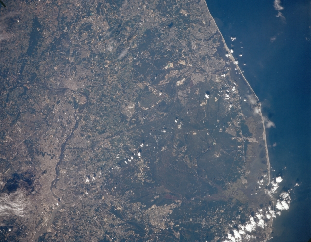
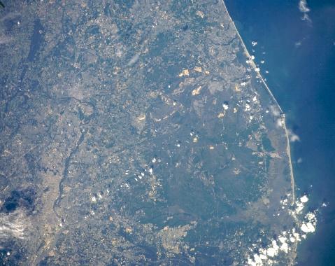
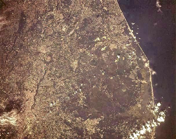
Image Caption: STS085-508-024 Delaware River, Pine Barrens, New Jersey August 1997
The Delaware River, the central New Jersey Coast, and the Pine Barrens are all visible in this north-northeast-looking low-oblique view. The Delaware River, 280 miles (450 km) long, rises in the Catskill Mountains of New York, enters the scene just above the left center of the image and flows generally southeastward passing Trenton, before turning southwestward. The river is most apparent as it passes Trenton and then exits the scene at the bottom left of the image. The large forested area covering much of the right half of the image is the Pine Barrens area of south-central New Jersey. A vast forest of pine, oak, and cedar on the outer coastal-plain, the Pine Barrens cover an area of 3000 sq. miles (7700 sq. km), and is the largest tract of open space on the mid-Atlantic Coast in what is the most urbanized state in the United States. The area is characterized by gently rolling terrain and sandy soils, swamp-edged streams, and tracts of cranberries and blueberries. Most of the Pine Barrens lies within a national reserve administered by the New Jersey Pinelands Commission.
The Delaware River, the central New Jersey Coast, and the Pine Barrens are all visible in this north-northeast-looking low-oblique view. The Delaware River, 280 miles (450 km) long, rises in the Catskill Mountains of New York, enters the scene just above the left center of the image and flows generally southeastward passing Trenton, before turning southwestward. The river is most apparent as it passes Trenton and then exits the scene at the bottom left of the image. The large forested area covering much of the right half of the image is the Pine Barrens area of south-central New Jersey. A vast forest of pine, oak, and cedar on the outer coastal-plain, the Pine Barrens cover an area of 3000 sq. miles (7700 sq. km), and is the largest tract of open space on the mid-Atlantic Coast in what is the most urbanized state in the United States. The area is characterized by gently rolling terrain and sandy soils, swamp-edged streams, and tracts of cranberries and blueberries. Most of the Pine Barrens lies within a national reserve administered by the New Jersey Pinelands Commission.
