STS085-501-133

| NASA Photo ID | STS085-501-133 |
| Focal Length | 250mm |
| Date taken | 1997.08.13 |
| Time taken | 15:27:27 GMT |
Resolutions offered for this image:
5230 x 4084 pixels 639 x 499 pixels 607 x 480 pixels 479 x 381 pixels
5230 x 4084 pixels 639 x 499 pixels 607 x 480 pixels 479 x 381 pixels

Cloud masks available for this image:
Spacecraft nadir point: 49.2° N, 96.9° W
Photo center point: 49.5° N, 99.0° W
Photo center point by machine learning:
Photo center point: 49.5° N, 99.0° W
Photo center point by machine learning:
Nadir to Photo Center: West
Spacecraft Altitude: 155 nautical miles (287km)
Country or Geographic Name: | CANADA-M |
Features: | PELICAN, ROCK & SWAN LAKE |
| Features Found Using Machine Learning: | |
Cloud Cover Percentage: | 0 (no clouds present) |
Sun Elevation Angle: | 39° |
Sun Azimuth: | 116° |
Camera: | Linhof |
Focal Length: | 250mm |
Camera Tilt: | 39 degrees |
Format: | 5046: Kodak, natural color positive, Lumiere 100/5046, ASA 100, standard base |
Film Exposure: | Normal |
| Additional Information | |
| Width | Height | Annotated | Cropped | Purpose | Links |
|---|---|---|---|---|---|
| 5230 pixels | 4084 pixels | No | No | Earth From Space collection | Download Image |
| 639 pixels | 499 pixels | No | No | Earth From Space collection | Download Image |
| 607 pixels | 480 pixels | No | No | Download Image | |
| 479 pixels | 381 pixels | Download Image |
Download Packaged File
Download a Google Earth KML for this Image
View photo footprint information
Download a GeoTIFF for this photo
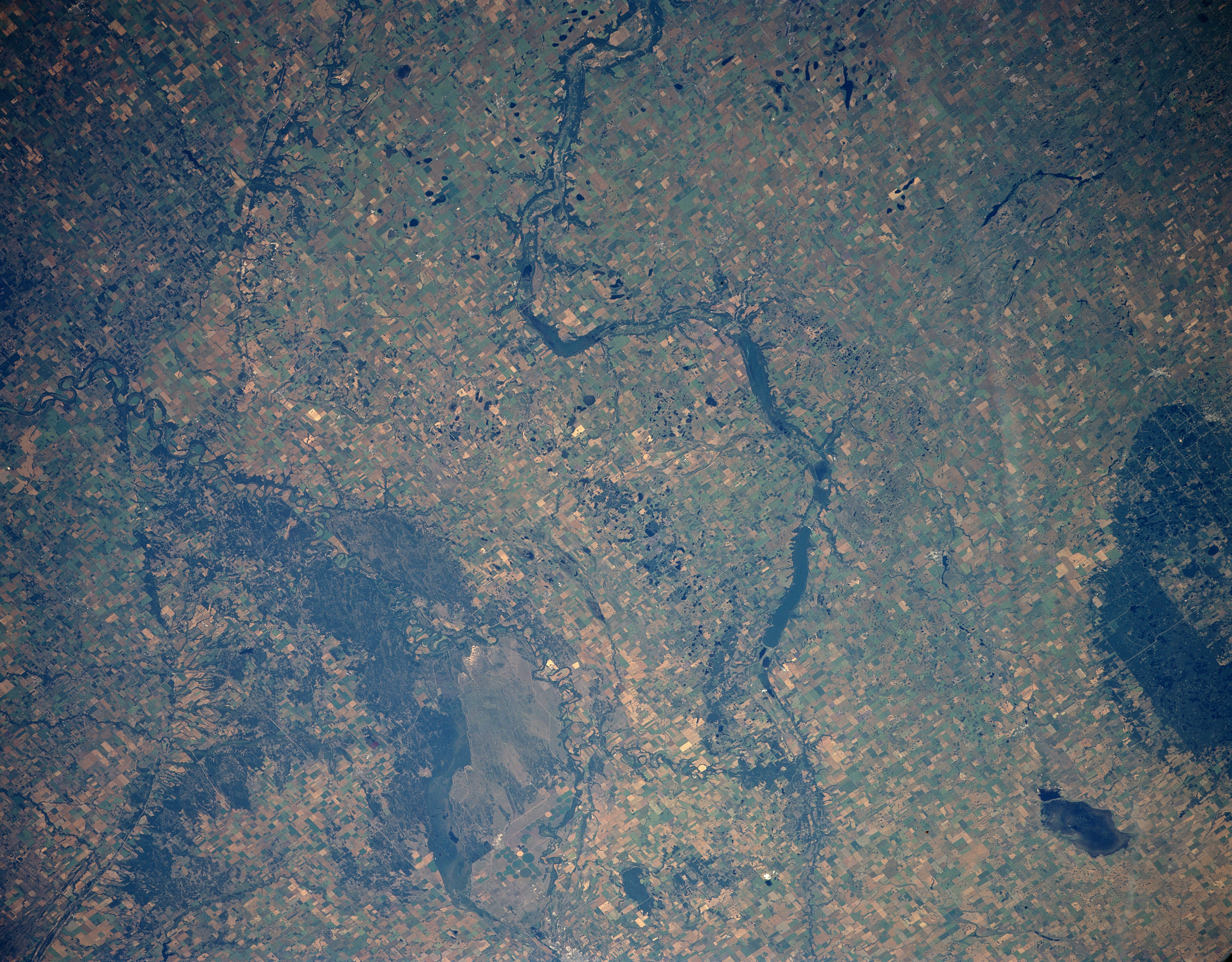
Image Caption: STS085-501-133 Pembina River Basin, Manitoba, Canada August 1997
The Pembina River and at least three elongated, intermittent lakes, including Pelican and Swan Lakes, (dark features) are visible where the river winds its way in an easterly direction across the plains of southwestern Manitoba. Landmarks in the scene include a section of the International Peace Garden (large forested area along the southern edge of the picture), which straddles the Canada-U. S. border; Whitewater Lake (smaller, dark feature immediately north of the International Peace Garden); and the dark forested area north of the Pembina River is Spruce Woods Provincial Park. The lighter colored, uniform-looking terrain south of the forested park is an area of open sand dunes, known as Canada's Living Desert. The wildly meandering course of the eastward flowing Assiniboine River is also visible south of the sand dunes (Baldhills Park) and Spruce Woods Provincial Park. Most of the land that is suitable for agriculture is used for the production of spring wheat.
The Pembina River and at least three elongated, intermittent lakes, including Pelican and Swan Lakes, (dark features) are visible where the river winds its way in an easterly direction across the plains of southwestern Manitoba. Landmarks in the scene include a section of the International Peace Garden (large forested area along the southern edge of the picture), which straddles the Canada-U. S. border; Whitewater Lake (smaller, dark feature immediately north of the International Peace Garden); and the dark forested area north of the Pembina River is Spruce Woods Provincial Park. The lighter colored, uniform-looking terrain south of the forested park is an area of open sand dunes, known as Canada's Living Desert. The wildly meandering course of the eastward flowing Assiniboine River is also visible south of the sand dunes (Baldhills Park) and Spruce Woods Provincial Park. Most of the land that is suitable for agriculture is used for the production of spring wheat.
