STS084-721-29
| NASA Photo ID | STS084-721-29 |
| Focal Length | 250mm |
| Date taken | 1997.05.__ |
| Time taken | GMT |
Resolutions offered for this image:
4096 x 4096 pixels 640 x 640 pixels 5700 x 5900 pixels 483 x 500 pixels 638 x 635 pixels
4096 x 4096 pixels 640 x 640 pixels 5700 x 5900 pixels 483 x 500 pixels 638 x 635 pixels

Cloud masks available for this image:
Spacecraft nadir point:
Photo center point: 52.5° N, 106.5° E
Photo center point by machine learning:
Photo center point: 52.5° N, 106.5° E
Photo center point by machine learning:
Nadir to Photo Center: East
Spacecraft Altitude: nautical miles (0km)
Country or Geographic Name: | RUSSIAN FEDERATION |
Features: | L. BAIKAL, SELENGA R. D. |
| Features Found Using Machine Learning: | |
Cloud Cover Percentage: | 0 (no clouds present) |
Sun Elevation Angle: | ° |
Sun Azimuth: | ° |
Camera: | Hasselblad |
Focal Length: | 250mm |
Camera Tilt: | Low Oblique |
Format: | 5069: Kodak Elite 100S, E6 Reversal, Replaces Lumiere, Warmer in tone vs. Lumiere |
Film Exposure: | Normal |
| Additional Information | |
| Width | Height | Annotated | Cropped | Purpose | Links |
|---|---|---|---|---|---|
| 4096 pixels | 4096 pixels | No | No | Earth From Space collection | Download Image |
| 640 pixels | 640 pixels | No | No | Earth From Space collection | Download Image |
| 5700 pixels | 5900 pixels | No | No | Download Image | |
| 483 pixels | 500 pixels | No | No | Download Image | |
| 638 pixels | 635 pixels | No | No | Download Image |
Download Packaged File
Download a Google Earth KML for this Image
View photo footprint information
Download a GeoTIFF for this photo
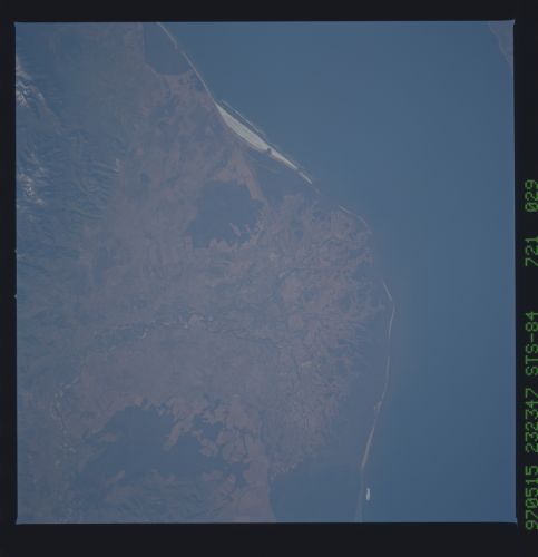
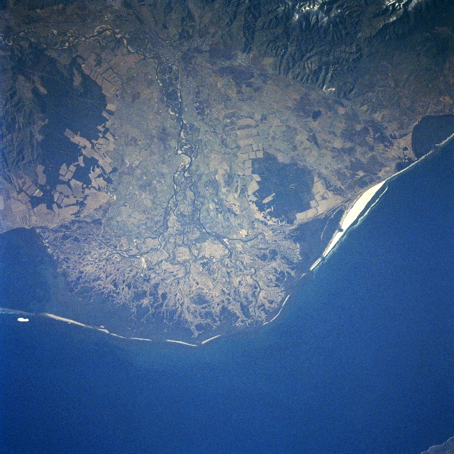
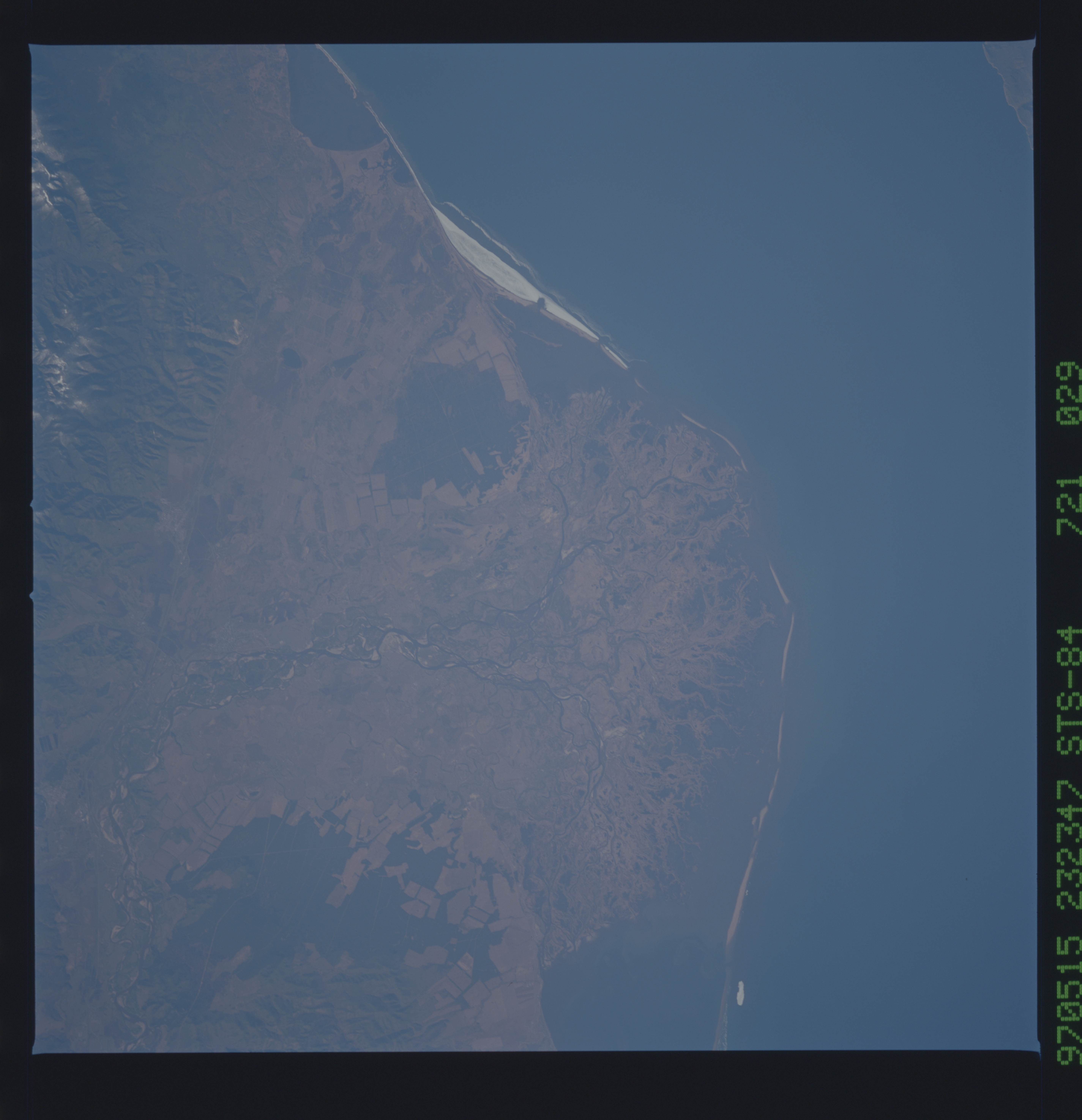
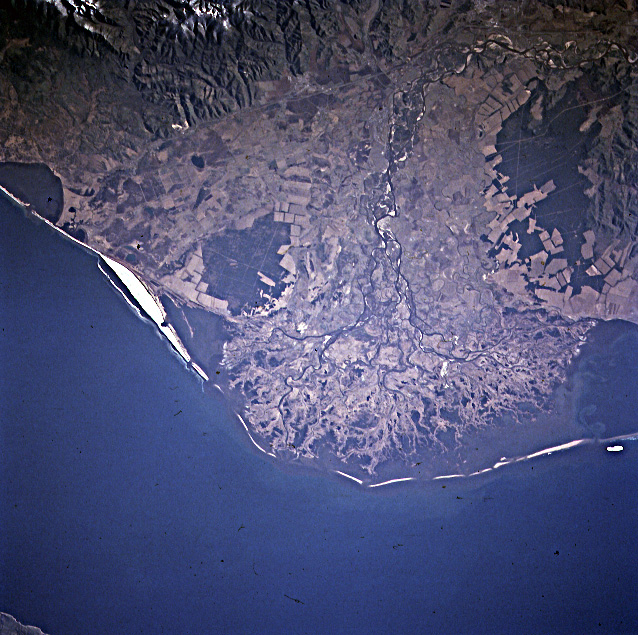
Image Caption: STS084-721-29 Selenga River Delta, Lake Baykal, Russia May 1997
The delta of the Selenga River, emptying into one of the oldest and deepest fresh water lakes in the world, Baykal, can be seen in this east-looking view. The Selenga River rises in the Khangai Mountains of northwest Mongolia and flows 616 miles (991 km) to its mouth at Lake Baykal. The delta is made-up of a swampy-grassy area that is the summer home to numerous birds and other species of wildlife. Industries, especially paper and pulp factories in the Selenga River Valley and in the industrial city of Ulan-Ude, were polluting the Selenga River and Lake Baykal. Since the 1980's, restrictions on the industrial waste dumping have gone in effect, and the flow of the polluted river water into the lake has been reduced significantly, and in some cases, completely stopped. The future of Lake Baykal and its unique environmental habitat looks brighter than it did just a few decades ago. Agricultural fields (angular patterns) can be seen scattered throughout the scene, but are especially noticeable on the lower slopes of hills near the right center of the image.
The delta of the Selenga River, emptying into one of the oldest and deepest fresh water lakes in the world, Baykal, can be seen in this east-looking view. The Selenga River rises in the Khangai Mountains of northwest Mongolia and flows 616 miles (991 km) to its mouth at Lake Baykal. The delta is made-up of a swampy-grassy area that is the summer home to numerous birds and other species of wildlife. Industries, especially paper and pulp factories in the Selenga River Valley and in the industrial city of Ulan-Ude, were polluting the Selenga River and Lake Baykal. Since the 1980's, restrictions on the industrial waste dumping have gone in effect, and the flow of the polluted river water into the lake has been reduced significantly, and in some cases, completely stopped. The future of Lake Baykal and its unique environmental habitat looks brighter than it did just a few decades ago. Agricultural fields (angular patterns) can be seen scattered throughout the scene, but are especially noticeable on the lower slopes of hills near the right center of the image.
