STS084-712-36

| NASA Photo ID | STS084-712-36 |
| Focal Length | 250mm |
| Date taken | 1997.05.21 |
| Time taken | 02:31:25 GMT |
Resolutions offered for this image:
4048 x 4048 pixels 639 x 639 pixels 5700 x 5900 pixels 483 x 500 pixels 639 x 638 pixels
4048 x 4048 pixels 639 x 639 pixels 5700 x 5900 pixels 483 x 500 pixels 639 x 638 pixels


Cloud masks available for this image:
Spacecraft nadir point: 16.4° S, 138.7° E
Photo center point: 16.0° S, 137.0° E
Photo center point by machine learning:
Photo center point: 16.0° S, 137.0° E
Photo center point by machine learning:
Nadir to Photo Center: West
Spacecraft Altitude: 214 nautical miles (396km)
Country or Geographic Name: | AUSTRALIA-NT |
Features: | SIR EDWARD PELLEW GROUP |
| Features Found Using Machine Learning: | |
Cloud Cover Percentage: | 0 (no clouds present) |
Sun Elevation Angle: | 53° |
Sun Azimuth: | 4° |
Camera: | Hasselblad |
Focal Length: | 250mm |
Camera Tilt: | 26 degrees |
Format: | 5069: Kodak Elite 100S, E6 Reversal, Replaces Lumiere, Warmer in tone vs. Lumiere |
Film Exposure: | Normal |
| Additional Information | |
| Width | Height | Annotated | Cropped | Purpose | Links |
|---|---|---|---|---|---|
| 4048 pixels | 4048 pixels | No | No | Earth From Space collection | Download Image |
| 639 pixels | 639 pixels | No | No | Earth From Space collection | Download Image |
| 5700 pixels | 5900 pixels | No | No | Download Image | |
| 483 pixels | 500 pixels | No | No | Download Image | |
| 639 pixels | 638 pixels | No | No | Download Image |
Download Packaged File
Download a Google Earth KML for this Image
View photo footprint information
Download a GeoTIFF for this photo
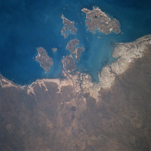
Image Caption: STS084-712-036 Sir Edward Pellew Group, Northern Territory, Australia May 1997
Named for the distinguished British Naval Officer, Sir Edward Pellew, these islands are located just off of the northeast coast of the Northern Territory along the southwest edge of the Gulf of Carpentaria. Although sparsely populated, culturally, this landscape of climatic extremes has been home to an aboriginal people called the Yanyuwa. Intense seasonal variations are the norm. For example the region usually experiences 6 to 8 rainless months per year. The low-lying coastal area (lighter-color) is made up of a mixture of tidal flats, rocky shoreline, and sandy beaches. Vanderlin Island is the largest, most easterly island in the Sir Edward Pellew Group. The waters around these islands are known for excellent sports fishing locations. The coastal areas around the islands also provide suitable feeding habitats for Green Turtles.
Named for the distinguished British Naval Officer, Sir Edward Pellew, these islands are located just off of the northeast coast of the Northern Territory along the southwest edge of the Gulf of Carpentaria. Although sparsely populated, culturally, this landscape of climatic extremes has been home to an aboriginal people called the Yanyuwa. Intense seasonal variations are the norm. For example the region usually experiences 6 to 8 rainless months per year. The low-lying coastal area (lighter-color) is made up of a mixture of tidal flats, rocky shoreline, and sandy beaches. Vanderlin Island is the largest, most easterly island in the Sir Edward Pellew Group. The waters around these islands are known for excellent sports fishing locations. The coastal areas around the islands also provide suitable feeding habitats for Green Turtles.
