STS084-706-80

| NASA Photo ID | STS084-706-80 |
| Focal Length | 100mm |
| Date taken | 1997.05.22 |
| Time taken | 17:04:15 GMT |
Resolutions offered for this image:
4096 x 4088 pixels 640 x 638 pixels 5700 x 5900 pixels 483 x 500 pixels
4096 x 4088 pixels 640 x 638 pixels 5700 x 5900 pixels 483 x 500 pixels


Cloud masks available for this image:
Spacecraft nadir point: 35.7° S, 68.1° W
Photo center point: 36.5° S, 69.5° W
Photo center point by machine learning:
Photo center point: 36.5° S, 69.5° W
Photo center point by machine learning:
Nadir to Photo Center: Southwest
Spacecraft Altitude: 214 nautical miles (396km)
Country or Geographic Name: | ARGENTINA |
Features: | PAYUN VOLCANO |
| Features Found Using Machine Learning: | |
Cloud Cover Percentage: | 0 (no clouds present) |
Sun Elevation Angle: | 33° |
Sun Azimuth: | 350° |
Camera: | Hasselblad |
Focal Length: | 100mm |
Camera Tilt: | 24 degrees |
Format: | 5069: Kodak Elite 100S, E6 Reversal, Replaces Lumiere, Warmer in tone vs. Lumiere |
Film Exposure: | Normal |
| Additional Information | |
| Width | Height | Annotated | Cropped | Purpose | Links |
|---|---|---|---|---|---|
| 4096 pixels | 4088 pixels | No | No | Earth From Space collection | Download Image |
| 640 pixels | 638 pixels | No | No | Earth From Space collection | Download Image |
| 5700 pixels | 5900 pixels | No | No | Download Image | |
| 483 pixels | 500 pixels | No | No | Download Image |
Download Packaged File
Download a Google Earth KML for this Image
View photo footprint information
Download a GeoTIFF for this photo
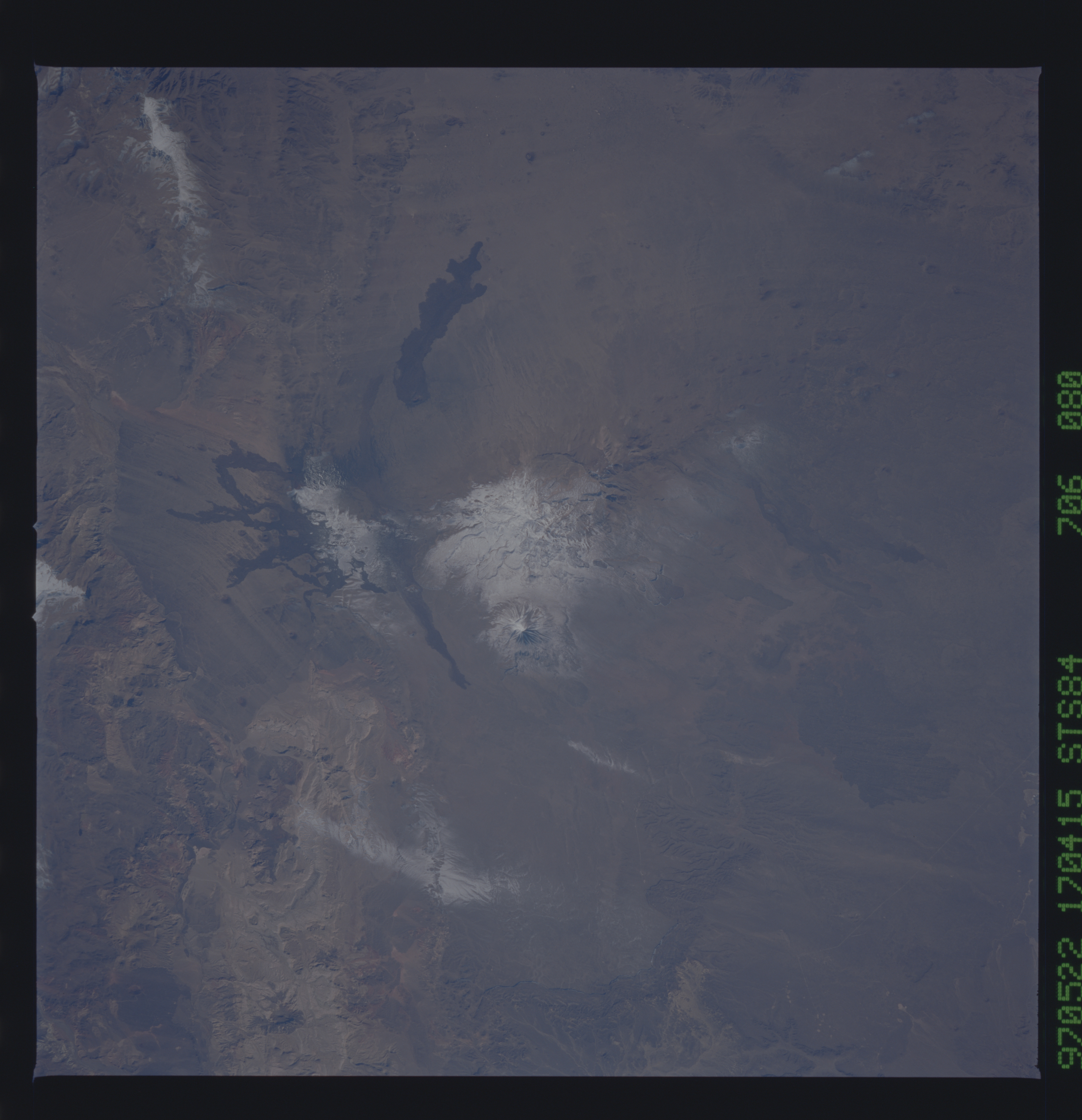
Image Caption: STS084-706-080 Payun Volcano and Peaks, Argentina May 1997
The snow-covered Payun Volcano is located in the Andes foothills of Patagonia and is an extinct shield volcano. Its elevation is 12073 feet (3682 meters). The last known eruption of the Payun volcanic area took place between 300,000 to 500,000 years ago. Lava flows can be seen to the west of the volcano midway between the center and top center of the image.
The snow-covered Payun Volcano is located in the Andes foothills of Patagonia and is an extinct shield volcano. Its elevation is 12073 feet (3682 meters). The last known eruption of the Payun volcanic area took place between 300,000 to 500,000 years ago. Lava flows can be seen to the west of the volcano midway between the center and top center of the image.
