STS080-748-75
| NASA Photo ID | STS080-748-75 |
| Focal Length | 250mm |
| Date taken | 1996.11.28 |
| Time taken | 05:10:50 GMT |
Resolutions offered for this image:
4096 x 4096 pixels 640 x 640 pixels 5700 x 5900 pixels 483 x 500 pixels 525 x 517 pixels
4096 x 4096 pixels 640 x 640 pixels 5700 x 5900 pixels 483 x 500 pixels 525 x 517 pixels

Cloud masks available for this image:
Spacecraft nadir point: 26.3° N, 97.3° E
Photo center point: 28.0° N, 95.5° E
Photo center point by machine learning:
Photo center point: 28.0° N, 95.5° E
Photo center point by machine learning:
Nadir to Photo Center: Northwest
Spacecraft Altitude: 189 nautical miles (350km)
Country or Geographic Name: | INDIA |
Features: | BRAHMAPUTRA R., DEFOREST. |
| Features Found Using Machine Learning: | |
Cloud Cover Percentage: | 5 (1-10)% |
Sun Elevation Angle: | 42° |
Sun Azimuth: | 177° |
Camera: | Hasselblad |
Focal Length: | 250mm |
Camera Tilt: | 38 degrees |
Format: | 5046: Kodak, natural color positive, Lumiere 100/5046, ASA 100, standard base |
Film Exposure: | Normal |
| Additional Information | |
| Width | Height | Annotated | Cropped | Purpose | Links |
|---|---|---|---|---|---|
| 4096 pixels | 4096 pixels | No | No | Earth From Space collection | Download Image |
| 640 pixels | 640 pixels | No | No | Earth From Space collection | Download Image |
| 5700 pixels | 5900 pixels | No | No | Download Image | |
| 483 pixels | 500 pixels | No | No | Download Image | |
| 525 pixels | 517 pixels | No | No | Download Image |
Download Packaged File
Download a Google Earth KML for this Image
View photo footprint information
Download a GeoTIFF for this photo
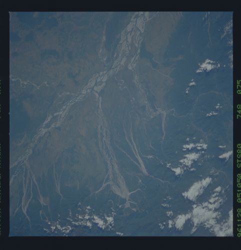
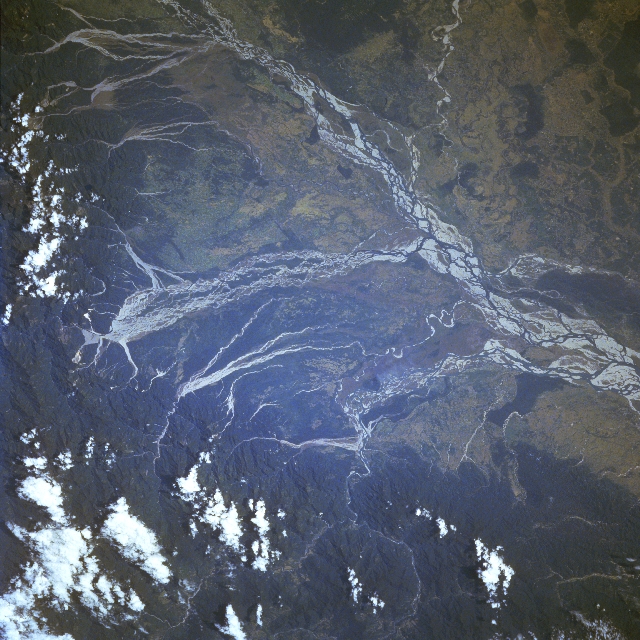
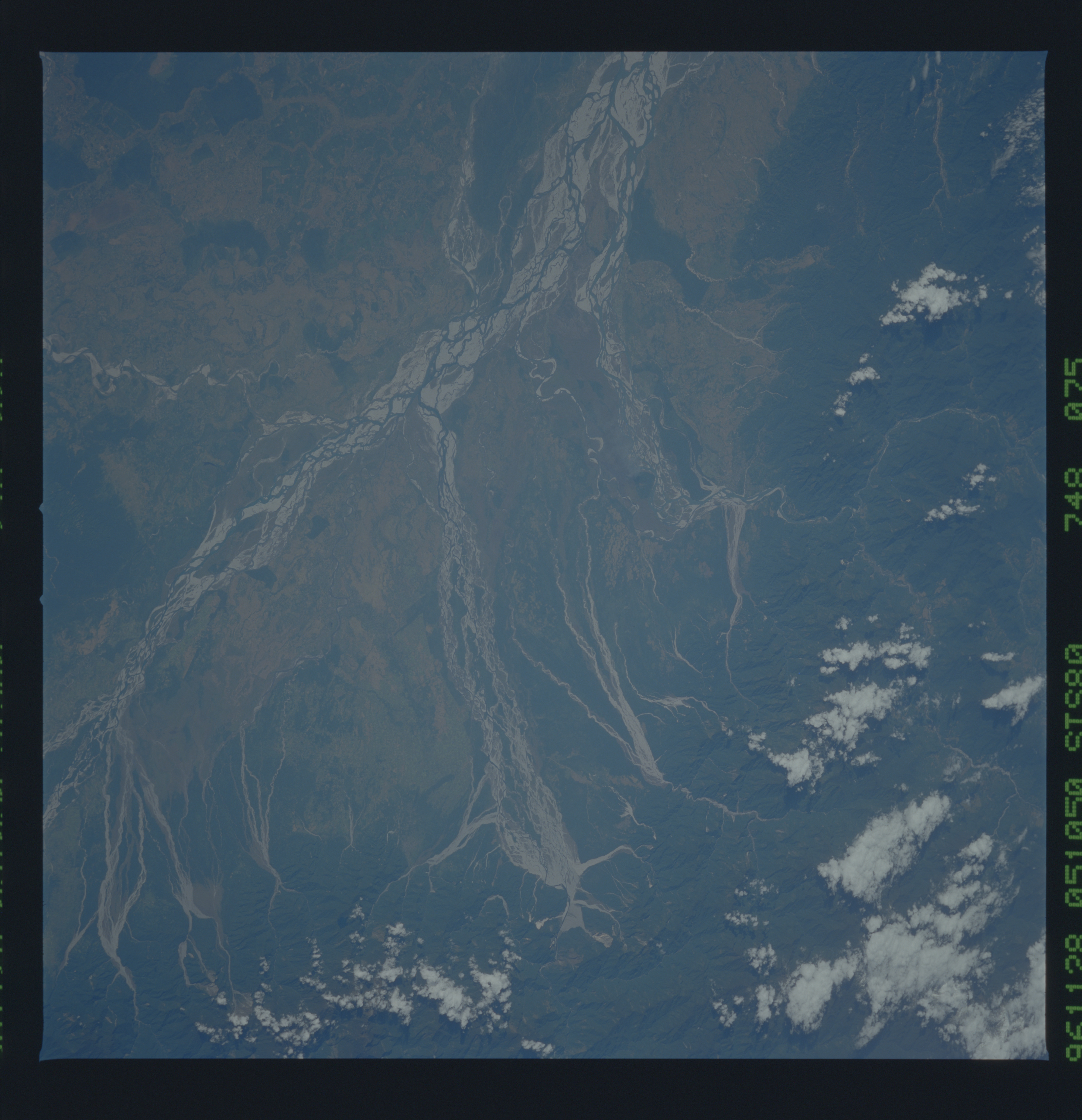
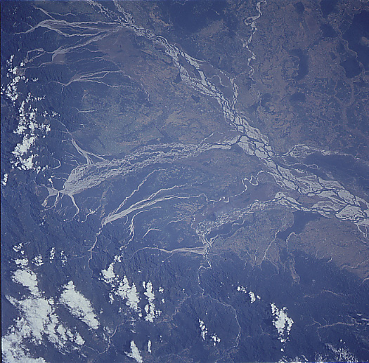
Image Caption: STS080-748-075 Brahmaputra River, India November 1996
The Brahmaputra River of northeast India is considered both destructive and beneficial to northeast India and Bangladesh. The river is destructive because on an annual basis, the wet summer monsoon that affects south Asia causes disastrous and frequent floods in the region. The river is beneficial because it carries rich soils that it deposits on the agricultural lands downstream. While the quantity of water that falls during the wet summer monsoon can vary from year to year, record amounts of rainfall exceed 400 inches (1016 cm) per monsoon season. As seen on this image, this tremendous quantity of water has created an immense floodplain. Within the floodplain there are numerous sand bars (highly reflective surfaces), islands, and multiple channels. Many of the southerly draining tributary streams of the Brahmaputra also display broad floodplains and multibraided stream channels as the tributaries exit the heavily forested (darker landscape) Himalayan Mountains. A deep, narrow gorge where the Brahmaputra River (known as the Dihang River as it flows through the mountains) cuts through the Himalayas is visible (light-colored, linear feature slight left of top center). A few scattered clouds are visible over sections of the mountains north of the Brahmaputra Valley.
The Brahmaputra River of northeast India is considered both destructive and beneficial to northeast India and Bangladesh. The river is destructive because on an annual basis, the wet summer monsoon that affects south Asia causes disastrous and frequent floods in the region. The river is beneficial because it carries rich soils that it deposits on the agricultural lands downstream. While the quantity of water that falls during the wet summer monsoon can vary from year to year, record amounts of rainfall exceed 400 inches (1016 cm) per monsoon season. As seen on this image, this tremendous quantity of water has created an immense floodplain. Within the floodplain there are numerous sand bars (highly reflective surfaces), islands, and multiple channels. Many of the southerly draining tributary streams of the Brahmaputra also display broad floodplains and multibraided stream channels as the tributaries exit the heavily forested (darker landscape) Himalayan Mountains. A deep, narrow gorge where the Brahmaputra River (known as the Dihang River as it flows through the mountains) cuts through the Himalayas is visible (light-colored, linear feature slight left of top center). A few scattered clouds are visible over sections of the mountains north of the Brahmaputra Valley.
