STS080-706-45
| NASA Photo ID | STS080-706-45 |
| Focal Length | 250mm |
| Date taken | 1996.11.24 |
| Time taken | 00:18:26 GMT |
Resolutions offered for this image:
4079 x 4079 pixels 639 x 639 pixels 5700 x 5900 pixels 483 x 500 pixels 655 x 643 pixels
4079 x 4079 pixels 639 x 639 pixels 5700 x 5900 pixels 483 x 500 pixels 655 x 643 pixels


Cloud masks available for this image:
Spacecraft nadir point: 15.4° N, 120.7° E
Photo center point: 15.0° N, 120.5° E
Photo center point by machine learning:
Photo center point: 15.0° N, 120.5° E
Photo center point by machine learning:
Nadir to Photo Center: South
Spacecraft Altitude: 188 nautical miles (348km)
Country or Geographic Name: | PHILIPPINES |
Features: | MT. PINATUBO, LAHARS, COAST |
| Features Found Using Machine Learning: | |
Cloud Cover Percentage: | 5 (1-10)% |
Sun Elevation Angle: | 28° |
Sun Azimuth: | 124° |
Camera: | Hasselblad |
Focal Length: | 250mm |
Camera Tilt: | 8 degrees |
Format: | 5046: Kodak, natural color positive, Lumiere 100/5046, ASA 100, standard base |
Film Exposure: | Normal |
| Additional Information | |
| Width | Height | Annotated | Cropped | Purpose | Links |
|---|---|---|---|---|---|
| 4079 pixels | 4079 pixels | No | No | Earth From Space collection | Download Image |
| 639 pixels | 639 pixels | No | No | Earth From Space collection | Download Image |
| 5700 pixels | 5900 pixels | No | No | Download Image | |
| 483 pixels | 500 pixels | No | No | Download Image | |
| 655 pixels | 643 pixels | No | No | Download Image |
Download Packaged File
Download a Google Earth KML for this Image
View photo footprint information
Download a GeoTIFF for this photo
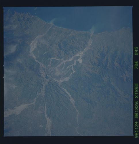
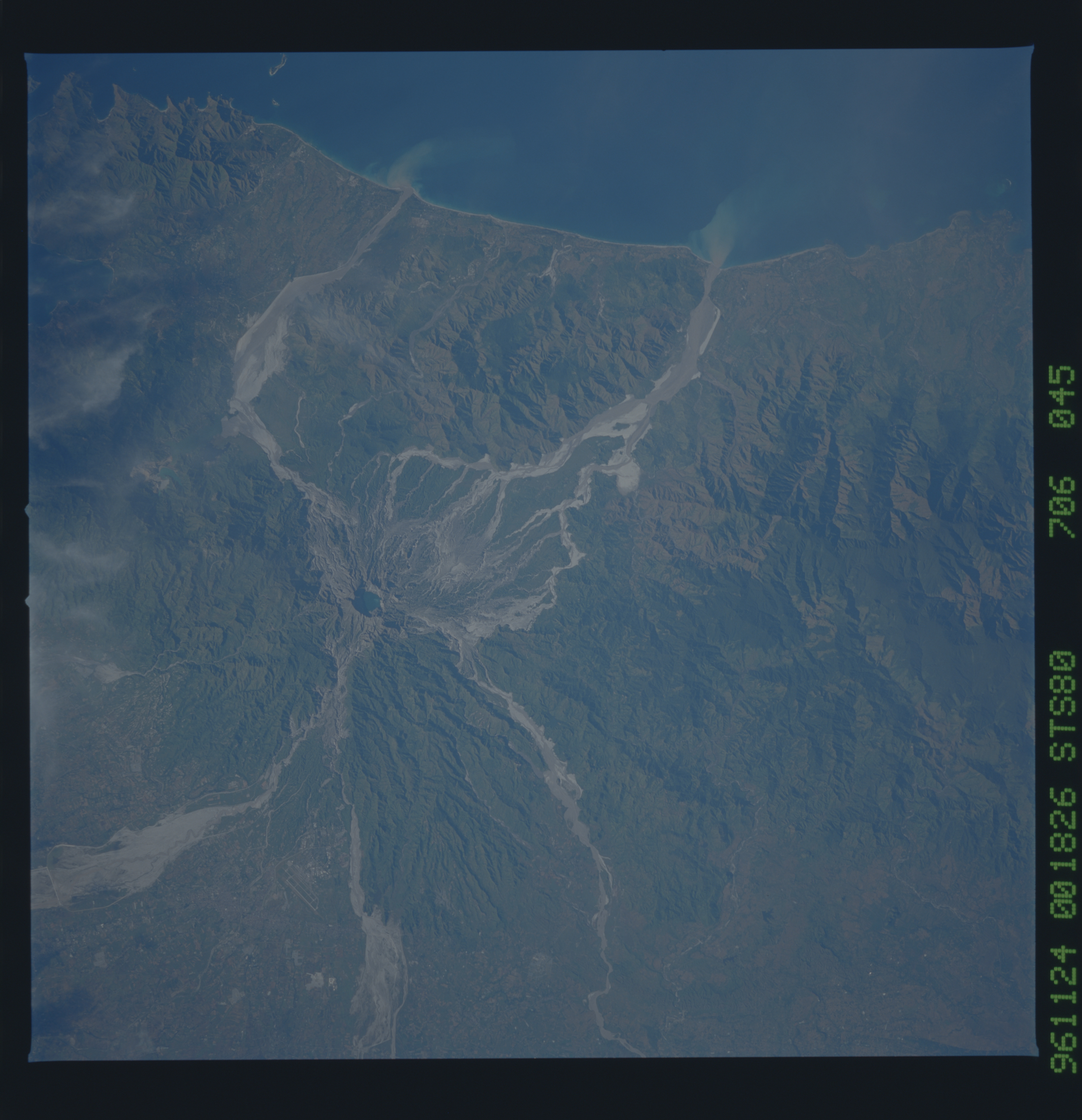
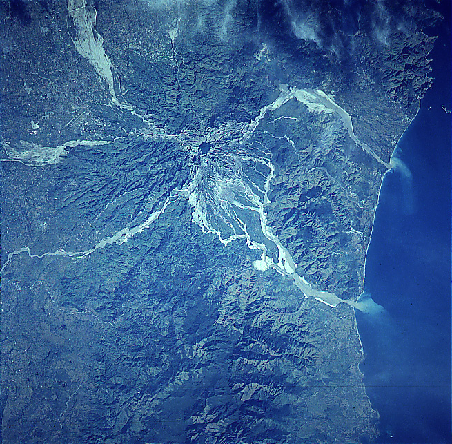
Image Caption: STS080-706-045 Mount Pinatubo Volcano, Philippines November 1996
The ash and mud deposits of Mount Pinatubo Volcano are visible in this southeast-looking view. Located on western Luzon Island, Mount Pinatubo is one of a chain of composite volcanoes that constitute the Luzon Volcanic Arc. The Volcano erupted on June 15th, 1991, and again in July and August of 1991. Ash from the massive explosion reached 50000 feet (15000 meters) into the atmosphere. Locally, the ash reached a depth of 10 feet (3 meters) on the ground. Typhoon Yunya, which struck the island of Luzon about the same time as the eruption of Mount Pinatubo, triggered massive mudslides that killed about 550 people. The paths of these mudslides or lahars are discernible on this image. Clark Air Force Base is visible between two of the mudslides in the upper left portion of the image. The 18000 personnel and their dependents were evacuated from the base before the volcanic eruption, as were over 60000 people that were living on the slopes and valleys around the volcano, thus saving many thousands of lives. Minor eruptions continue at Mount Pinatubo. Annual tropical rains continue to cause ash and mudslides into the valleys surrounding the volcano. At the time this image was obtained, water filled the crater floor of the volcano. Sediment plumes are visible entering the South China Sea to the west of the volcano.
The ash and mud deposits of Mount Pinatubo Volcano are visible in this southeast-looking view. Located on western Luzon Island, Mount Pinatubo is one of a chain of composite volcanoes that constitute the Luzon Volcanic Arc. The Volcano erupted on June 15th, 1991, and again in July and August of 1991. Ash from the massive explosion reached 50000 feet (15000 meters) into the atmosphere. Locally, the ash reached a depth of 10 feet (3 meters) on the ground. Typhoon Yunya, which struck the island of Luzon about the same time as the eruption of Mount Pinatubo, triggered massive mudslides that killed about 550 people. The paths of these mudslides or lahars are discernible on this image. Clark Air Force Base is visible between two of the mudslides in the upper left portion of the image. The 18000 personnel and their dependents were evacuated from the base before the volcanic eruption, as were over 60000 people that were living on the slopes and valleys around the volcano, thus saving many thousands of lives. Minor eruptions continue at Mount Pinatubo. Annual tropical rains continue to cause ash and mudslides into the valleys surrounding the volcano. At the time this image was obtained, water filled the crater floor of the volcano. Sediment plumes are visible entering the South China Sea to the west of the volcano.
