STS078-732-88
| NASA Photo ID | STS078-732-88 |
| Focal Length | 250mm |
| Date taken | 1996.06.24 |
| Time taken | 10:32:32 GMT |
Resolutions offered for this image:
4041 x 4028 pixels 639 x 637 pixels 5700 x 5900 pixels 483 x 500 pixels 520 x 515 pixels
4041 x 4028 pixels 639 x 637 pixels 5700 x 5900 pixels 483 x 500 pixels 520 x 515 pixels

Cloud masks available for this image:
Spacecraft nadir point: 29.7° N, 49.0° E
Photo center point: 30.5° N, 49.0° E
Photo center point by machine learning:
Photo center point: 30.5° N, 49.0° E
Photo center point by machine learning:
Nadir to Photo Center: North
Spacecraft Altitude: 146 nautical miles (270km)
Country or Geographic Name: | IRAN |
Features: | NORTHERN END PERSIAN G. |
| Features Found Using Machine Learning: | |
Cloud Cover Percentage: | 0 (no clouds present) |
Sun Elevation Angle: | 66° |
Sun Azimuth: | 262° |
Camera: | Hasselblad |
Focal Length: | 250mm |
Camera Tilt: | 18 degrees |
Format: | 5046: Kodak, natural color positive, Lumiere 100/5046, ASA 100, standard base |
Film Exposure: | Normal |
| Additional Information | |
| Width | Height | Annotated | Cropped | Purpose | Links |
|---|---|---|---|---|---|
| 4041 pixels | 4028 pixels | No | No | Earth From Space collection | Download Image |
| 639 pixels | 637 pixels | No | No | Earth From Space collection | Download Image |
| 5700 pixels | 5900 pixels | No | No | Download Image | |
| 483 pixels | 500 pixels | No | No | Download Image | |
| 520 pixels | 515 pixels | No | No | Download Image |
Download Packaged File
Download a Google Earth KML for this Image
View photo footprint information
Download a GeoTIFF for this photo
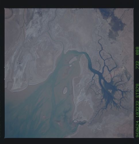
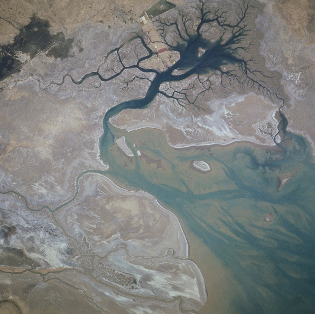
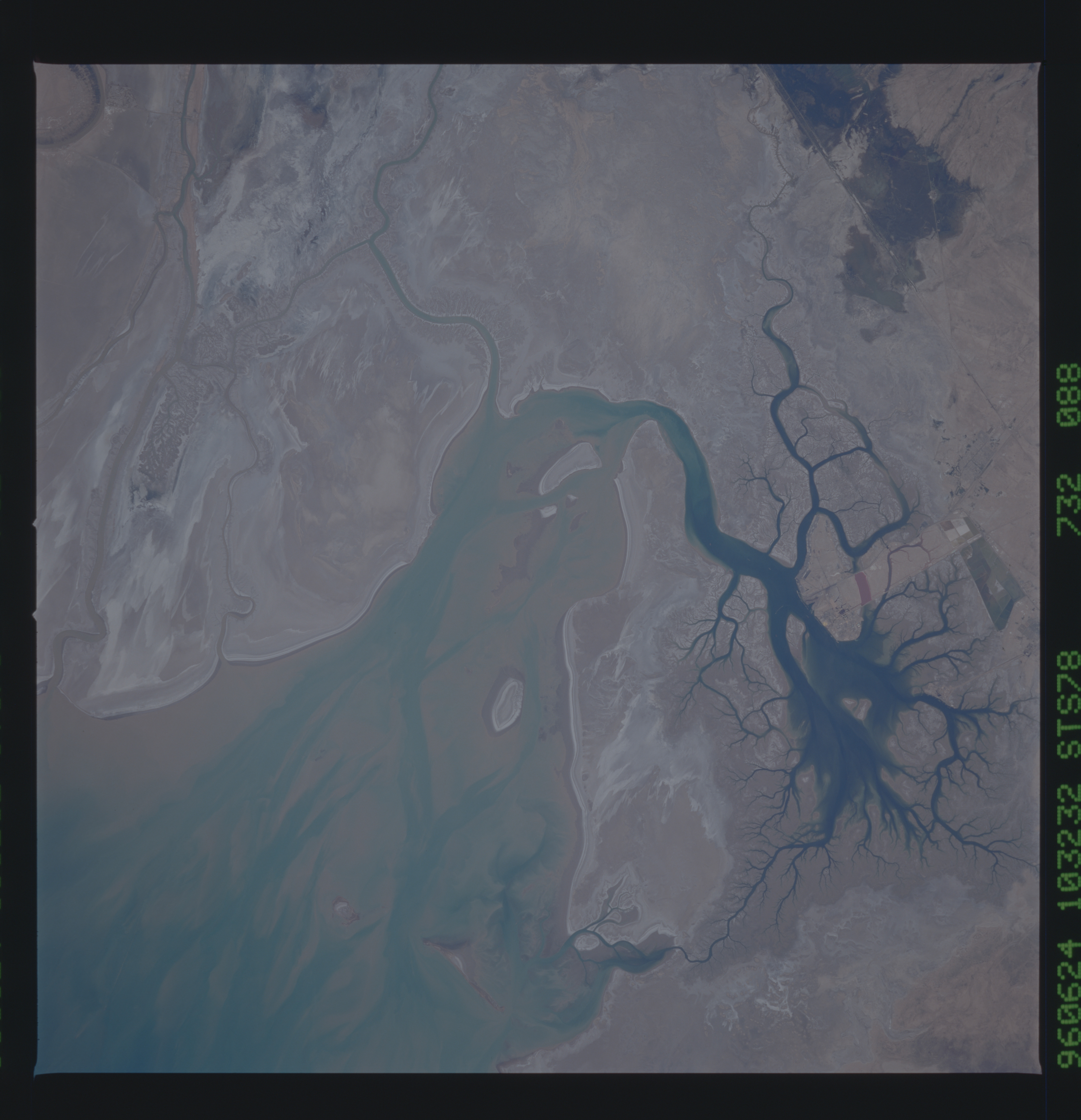
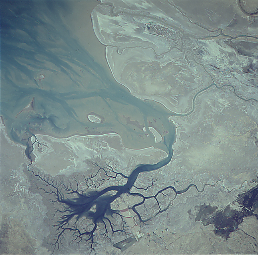
Image Caption: STS078-732-088 Karun River Delta, Iran June 1996
The Karun River, along with Tigris and Euphrates Rivers immediately west of this area, has formed a broad deltaic plain at the northern end of the Persian (Arabian) Gulf. This section of coastal plain is located in the southwest corner of Iran and includes sandy beaches, intertidal flats, and small estuaries. Large quantities of sand and silt are deposited at the mouths of the distributary channels (darker, meandering features upper half of the image) of the Karun River. Except for the deeper channels (darker blues), the coastal waters appear to be shallow with extensive sandbars (tannish-looking features) and a few islands. The darker water inlet (near bottom center) displays an intricate drainage pattern. The Iranian port city of Bandar-e Khomeyni is situated along the northern edge of this inland harbor. The straight, linear features (lower right corner) are highway and pipeline right of ways.
The Karun River, along with Tigris and Euphrates Rivers immediately west of this area, has formed a broad deltaic plain at the northern end of the Persian (Arabian) Gulf. This section of coastal plain is located in the southwest corner of Iran and includes sandy beaches, intertidal flats, and small estuaries. Large quantities of sand and silt are deposited at the mouths of the distributary channels (darker, meandering features upper half of the image) of the Karun River. Except for the deeper channels (darker blues), the coastal waters appear to be shallow with extensive sandbars (tannish-looking features) and a few islands. The darker water inlet (near bottom center) displays an intricate drainage pattern. The Iranian port city of Bandar-e Khomeyni is situated along the northern edge of this inland harbor. The straight, linear features (lower right corner) are highway and pipeline right of ways.
