STS077-717-18

| NASA Photo ID | STS077-717-18 |
| Focal Length | 40mm |
| Date taken | 1996.05.25 |
| Time taken | 04:54:14 GMT |
Resolutions offered for this image:
5312 x 5312 pixels 640 x 640 pixels 5700 x 5900 pixels 500 x 518 pixels 640 x 480 pixels
5312 x 5312 pixels 640 x 640 pixels 5700 x 5900 pixels 500 x 518 pixels 640 x 480 pixels

Cloud masks available for this image:
Spacecraft nadir point: 36.6° N, 32.8° E
Photo center point: 35.5° N, 33.0° E
Photo center point by machine learning:
Photo center point: 35.5° N, 33.0° E
Photo center point by machine learning:
Nadir to Photo Center: South
Spacecraft Altitude: 151 nautical miles (280km)
Country or Geographic Name: | CYPRUS |
Features: | ENTIRE I., TURKISH COAST |
| Features Found Using Machine Learning: | |
Cloud Cover Percentage: | 30 (26-50)% |
Sun Elevation Angle: | 26° |
Sun Azimuth: | 82° |
Camera: | Hasselblad |
Focal Length: | 40mm |
Camera Tilt: | 24 degrees |
Format: | 5046: Kodak, natural color positive, Lumiere 100/5046, ASA 100, standard base |
Film Exposure: | Normal |
| Additional Information | |
| Width | Height | Annotated | Cropped | Purpose | Links |
|---|---|---|---|---|---|
| 5312 pixels | 5312 pixels | No | No | Earth From Space collection | Download Image |
| 640 pixels | 640 pixels | No | No | Earth From Space collection | Download Image |
| 5700 pixels | 5900 pixels | No | No | Download Image | |
| 500 pixels | 518 pixels | No | No | Download Image | |
| 640 pixels | 480 pixels | No | No | Download Image |
Download Packaged File
Download a Google Earth KML for this Image
View photo footprint information
Download a GeoTIFF for this photo
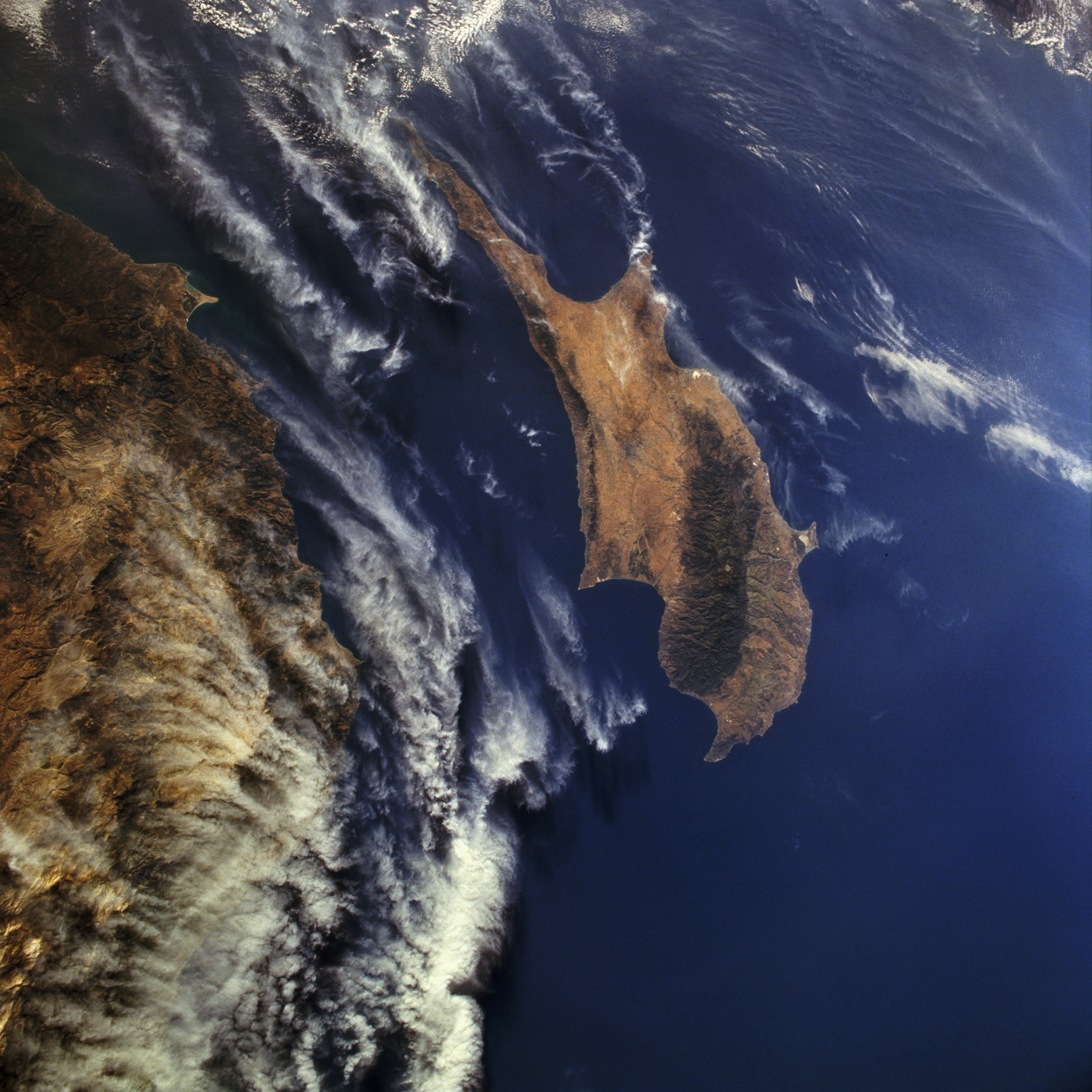
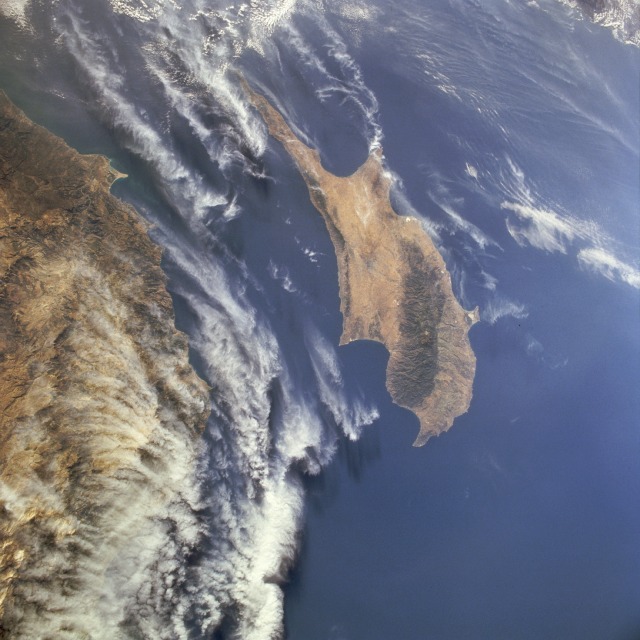
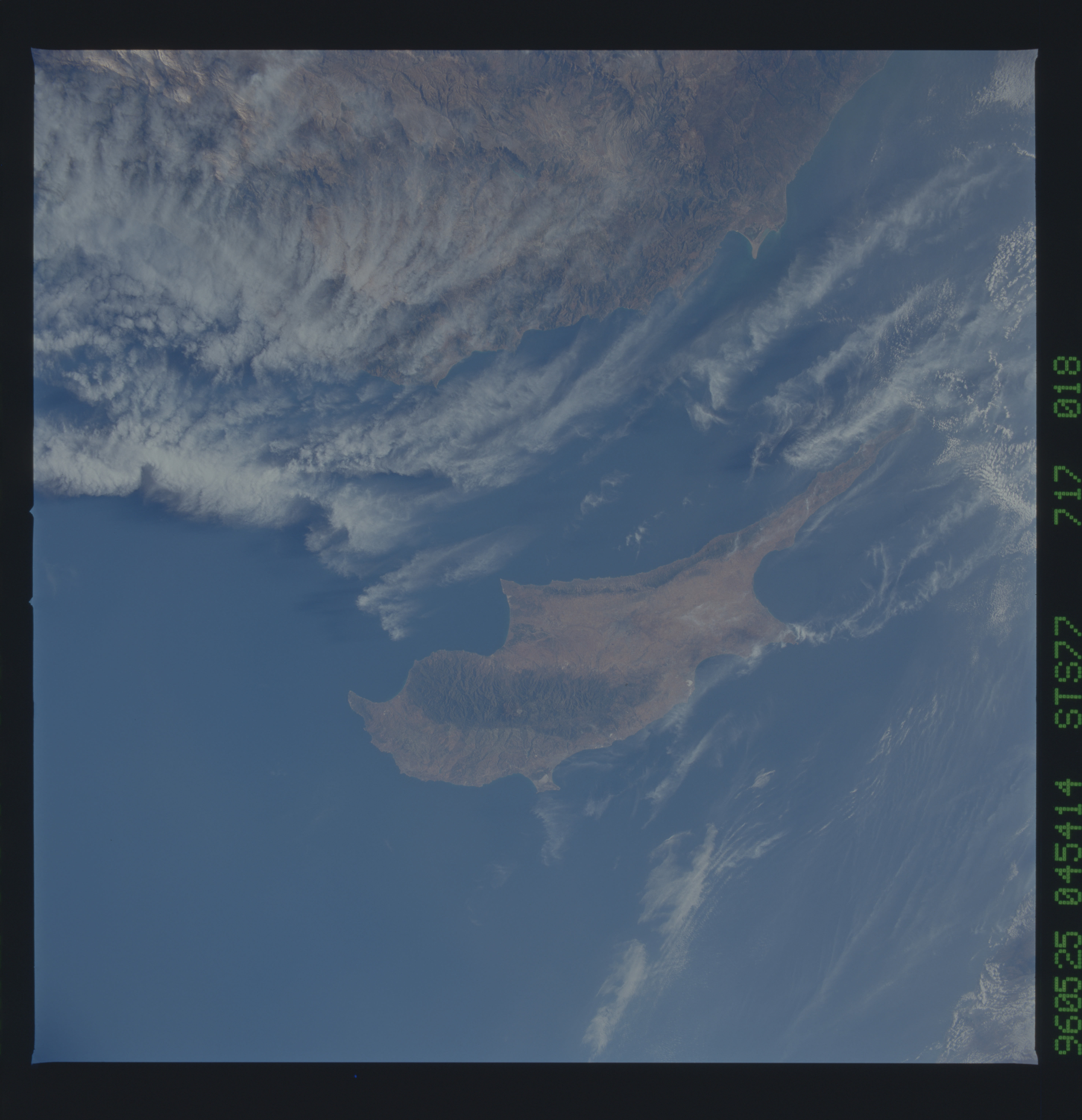
Image Caption: STS077-717-018 Cyprus May 1996
Cyprus, covering 3578 square miles (9267 square kilometers) in the eastern Mediterranean Sea 40 miles (60 kilometers) south of Turkey, is apparent in this south-looking, low-oblique photograph. The island has an irregular shape, a number of wide bays and prominent capes, and two east-west-oriented mountain ranges--the higher Troödos Mountains in the southwest and the lower Kyrenia Mountains in the north-northeast. Between the mountain ranges lies a wide plain, the island's chief agricultural area that produces grapes (used for wine making), cereals, olives, tobacco, citrus fruits, and cotton. Sheep and goat raising, silkworm cultivation, and fishing are important livelihoods on the island. Mineral resources include copper, gypsum, chrome, and asbestos. Cape Bagase is the small protrusion into the Mediterranean Sea from the Turkish mainland (lower left). Clouds cover most of the Taurus Mountains of Turkey (bottom third of the photograph).
Cyprus, covering 3578 square miles (9267 square kilometers) in the eastern Mediterranean Sea 40 miles (60 kilometers) south of Turkey, is apparent in this south-looking, low-oblique photograph. The island has an irregular shape, a number of wide bays and prominent capes, and two east-west-oriented mountain ranges--the higher Troödos Mountains in the southwest and the lower Kyrenia Mountains in the north-northeast. Between the mountain ranges lies a wide plain, the island's chief agricultural area that produces grapes (used for wine making), cereals, olives, tobacco, citrus fruits, and cotton. Sheep and goat raising, silkworm cultivation, and fishing are important livelihoods on the island. Mineral resources include copper, gypsum, chrome, and asbestos. Cape Bagase is the small protrusion into the Mediterranean Sea from the Turkish mainland (lower left). Clouds cover most of the Taurus Mountains of Turkey (bottom third of the photograph).
