STS073-726-51
| NASA Photo ID | STS073-726-51 |
| Focal Length | 250mm |
| Date taken | 1995.__.__ |
| Time taken | GMT |


Cloud masks available for this image:
Spacecraft nadir point:
Photo center point: 29.0° N, 90.5° W
Photo center point by machine learning:
Photo center point: 29.0° N, 90.5° W
Photo center point by machine learning:
Nadir to Photo Center:
Spacecraft Altitude: nautical miles (0km)
Country or Geographic Name: | USA-LOUISIANA |
Features: | MISSISSIPPI R. & DELTA |
| Features Found Using Machine Learning: | |
Cloud Cover Percentage: | 0 (no clouds present) |
Sun Elevation Angle: | ° |
Sun Azimuth: | ° |
Camera: | Hasselblad |
Focal Length: | 250mm |
Camera Tilt: | Low Oblique |
Format: | 5046: Kodak, natural color positive, Lumiere 100/5046, ASA 100, standard base |
Film Exposure: | Normal |
| Additional Information | |
| Width | Height | Annotated | Cropped | Purpose | Links |
|---|---|---|---|---|---|
| 5700 pixels | 5900 pixels | No | No | Download Image | |
| 500 pixels | 518 pixels | No | No | Download Image | |
| 640 pixels | 480 pixels | No | No | Download Image |
Download Packaged File
Download a Google Earth KML for this Image
View photo footprint information
Download a GeoTIFF for this photo
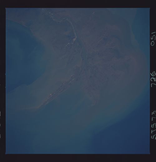
Image Caption: The current Mississippi River Delta. The Mississippi has
been in its present course for approximately the last 550 years. This
river provides access to the grain producing regions of the United
States . South Pass is one of the major shipping channels in the
United States. Because of the need to keep the channels dredged much
of the sediment that comes down the Mississippi is now funneled
offshore and does not continue to provide new material to build the
delta.
