STS073-704-84

| NASA Photo ID | STS073-704-84 |
| Focal Length | 250mm |
| Date taken | 1995.10.22 |
| Time taken | 18:32:35 GMT |
Resolutions offered for this image:
3904 x 3936 pixels 634 x 639 pixels 5700 x 5900 pixels 500 x 518 pixels 640 x 480 pixels
3904 x 3936 pixels 634 x 639 pixels 5700 x 5900 pixels 500 x 518 pixels 640 x 480 pixels


Cloud masks available for this image:
Spacecraft nadir point: 39.1° N, 112.9° W
Photo center point: 39.5° N, 119.0° W
Photo center point by machine learning:
Photo center point: 39.5° N, 119.0° W
Photo center point by machine learning:
Nadir to Photo Center: West
Spacecraft Altitude: 146 nautical miles (270km)
Country or Geographic Name: | USA-NEVADA |
Features: | PYRAMID L., CARSON SINK |
| Features Found Using Machine Learning: | |
Cloud Cover Percentage: | 5 (1-10)% |
Sun Elevation Angle: | 39° |
Sun Azimuth: | 166° |
Camera: | Hasselblad |
Focal Length: | 250mm |
Camera Tilt: | Low Oblique |
Format: | 5046: Kodak, natural color positive, Lumiere 100/5046, ASA 100, standard base |
Film Exposure: | Normal |
| Additional Information | |
| Width | Height | Annotated | Cropped | Purpose | Links |
|---|---|---|---|---|---|
| 3904 pixels | 3936 pixels | No | No | Earth From Space collection | Download Image |
| 634 pixels | 639 pixels | No | No | Earth From Space collection | Download Image |
| 5700 pixels | 5900 pixels | No | No | Download Image | |
| 500 pixels | 518 pixels | No | No | Download Image | |
| 640 pixels | 480 pixels | No | No | Download Image |
Download Packaged File
Download a Google Earth KML for this Image
View photo footprint information
Download a GeoTIFF for this photo
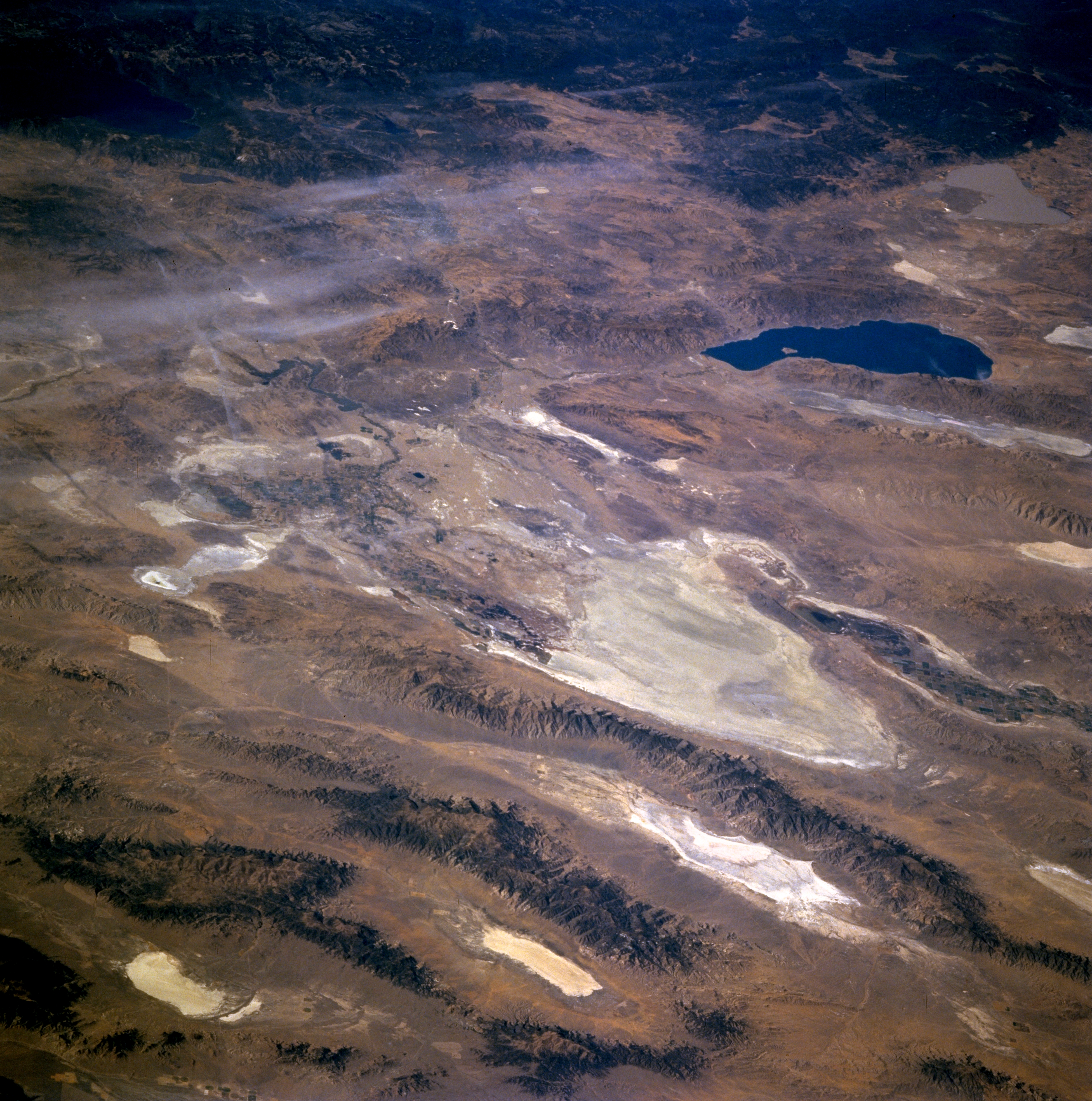
Image Caption: STS073-704-084 Carson Sink, Nevada, U.S.A. October 1995
Large, highly reflective Carson Sink, near the center of this low-oblique, west-looking photograph, is a dry lakebed measuring approximately 20 miles (32 kilometers) in diameter. A part of the larger Carson Desert, Carson Sink is very flat, with an elevation that varies less than 10 feet in its central part. Its salt-encrusted surface is devoid of vegetation except for small areas of saw grass at the mouths of the Carson River, which enters the sink from the southwest, and the Humboldt River, which enters the sink from the north. Because both of these rivers flow only intermittently, with any available water being diverted for agriculture farther upstream, little water actually reaches Carson Sink. A series of northeast-southwest-oriented mountain ranges east of Carson Sink--the Stillwater Range, Clan Alpine Mountains, and Desatoya Mountains--are separated by valleys that contain smaller, highly reflective dry lakes. Large Pyramid Lake and Lake Tahoe appear west and southwest, respectively, of Carson Sink.
Large, highly reflective Carson Sink, near the center of this low-oblique, west-looking photograph, is a dry lakebed measuring approximately 20 miles (32 kilometers) in diameter. A part of the larger Carson Desert, Carson Sink is very flat, with an elevation that varies less than 10 feet in its central part. Its salt-encrusted surface is devoid of vegetation except for small areas of saw grass at the mouths of the Carson River, which enters the sink from the southwest, and the Humboldt River, which enters the sink from the north. Because both of these rivers flow only intermittently, with any available water being diverted for agriculture farther upstream, little water actually reaches Carson Sink. A series of northeast-southwest-oriented mountain ranges east of Carson Sink--the Stillwater Range, Clan Alpine Mountains, and Desatoya Mountains--are separated by valleys that contain smaller, highly reflective dry lakes. Large Pyramid Lake and Lake Tahoe appear west and southwest, respectively, of Carson Sink.
