STS070-738-78

| NASA Photo ID | STS070-738-78 |
| Focal Length | 100mm |
| Date taken | 1995.07.16 |
| Time taken | 11:38:10 GMT |
Cloud masks available for this image:
Spacecraft nadir point: 15.2° S, 46.8° E
Photo center point: 16.0° S, 46.5° E
Photo center point by machine learning:
Photo center point: 16.0° S, 46.5° E
Photo center point by machine learning:
Nadir to Photo Center: South
Spacecraft Altitude: 156 nautical miles (289km)
Country or Geographic Name: | MADAGASCAR |
Features: | BETSIBOKA R. DELTA, SED. |
| Features Found Using Machine Learning: | |
Cloud Cover Percentage: | 0 (no clouds present) |
Sun Elevation Angle: | 37° |
Sun Azimuth: | 312° |
Camera: | Hasselblad |
Focal Length: | 100mm |
Camera Tilt: | 18 degrees |
Format: | 2443: Kodak Aerochrome 2443, color IR, thin base, EA-5 process thru June 1999, E-6 process afterward |
Film Exposure: | Normal |
| Additional Information | |
| Width | Height | Annotated | Cropped | Purpose | Links |
|---|---|---|---|---|---|
| 5700 pixels | 5900 pixels | No | No | Download Image | |
| 500 pixels | 518 pixels | No | No | Download Image | |
| 640 pixels | 480 pixels | No | No | Download Image |
Download Packaged File
Download a Google Earth KML for this Image
View photo footprint information
Download a GeoTIFF for this photo
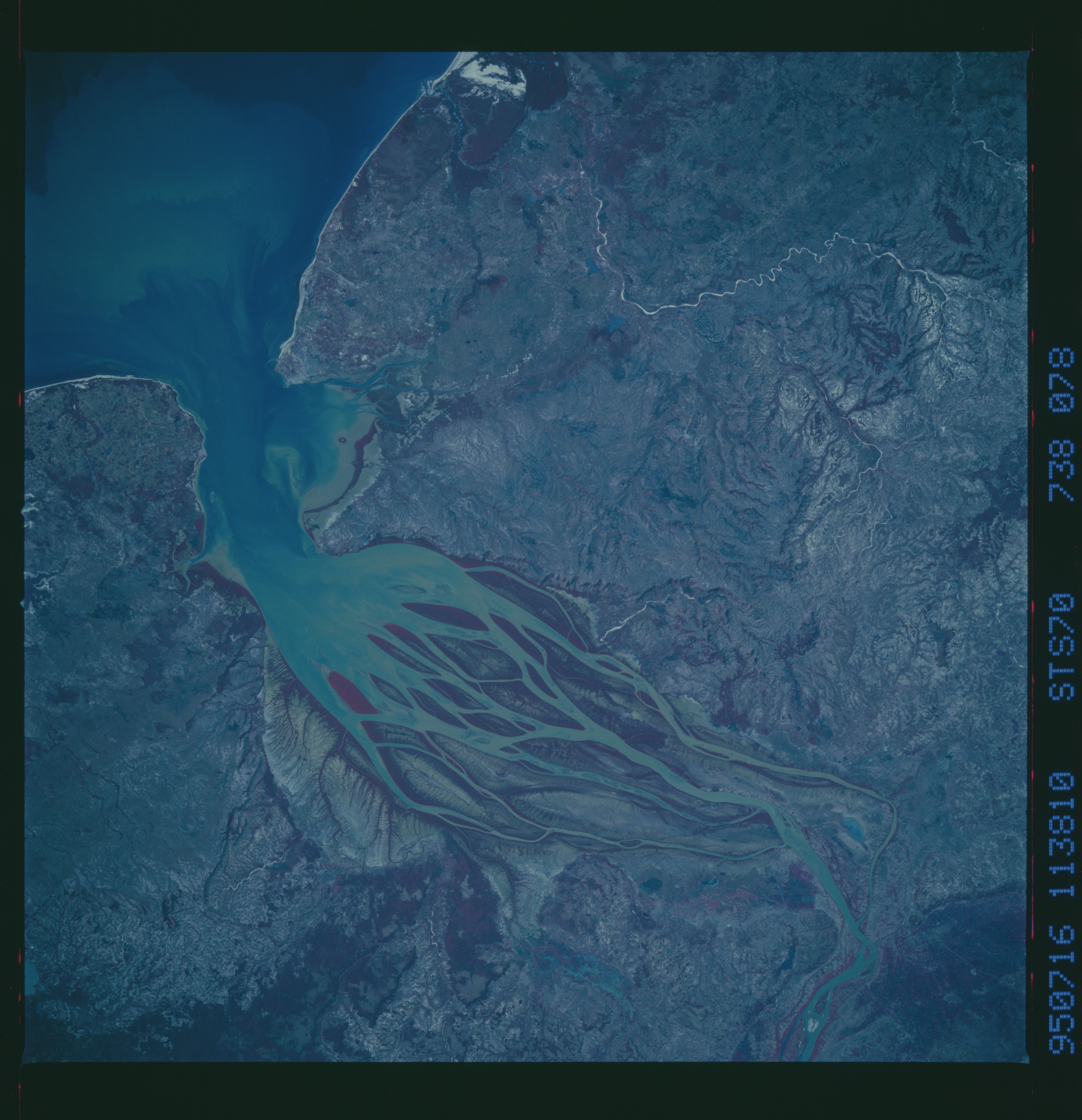
Image Caption: Betsiboka River delta, NW Madagascar
The estuary of the Betsiboka River (left center) has been half filled by sediment brought down from inland by the Betsiboka River (which enters the view bottom left). The sediment appears in this dramatic color-infrared view as a series of elliptical islands which now reach more than half the distance to the mouth of the estuary.
The islands did not exist before WWII, so that the estuary acted as a waterway for oceangoing ships to a now-abandoned port at the original head of the estuary. Heavy deforestation since WWII has probably contributed to the degree of the sedimentation in this estuary.
