STS069-737-51
| NASA Photo ID | STS069-737-51 |
| Focal Length | 100mm |
| Date taken | 1995.09.13 |
| Time taken | 15:48:45 GMT |
Resolutions offered for this image:
4025 x 4025 pixels 639 x 639 pixels 5700 x 5900 pixels 500 x 518 pixels 640 x 480 pixels
4025 x 4025 pixels 639 x 639 pixels 5700 x 5900 pixels 500 x 518 pixels 640 x 480 pixels


Cloud masks available for this image:
Spacecraft nadir point: 5.4° N, 58.4° W
Photo center point: 6.5° N, 58.5° W
Photo center point by machine learning:
Photo center point: 6.5° N, 58.5° W
Photo center point by machine learning:
Nadir to Photo Center: North
Spacecraft Altitude: 216 nautical miles (400km)
Country or Geographic Name: | GUYANA |
Features: | ESSEQUIBO RIVER DELTA |
| Features Found Using Machine Learning: | |
Cloud Cover Percentage: | 30 (26-50)% |
Sun Elevation Angle: | 88° |
Sun Azimuth: | 174° |
Camera: | Hasselblad |
Focal Length: | 100mm |
Camera Tilt: | 17 degrees |
Format: | 2443: Kodak Aerochrome 2443, color IR, thin base, EA-5 process thru June 1999, E-6 process afterward |
Film Exposure: | Normal |
| Additional Information | |
| Width | Height | Annotated | Cropped | Purpose | Links |
|---|---|---|---|---|---|
| 4025 pixels | 4025 pixels | No | No | Earth From Space collection | Download Image |
| 639 pixels | 639 pixels | No | No | Earth From Space collection | Download Image |
| 5700 pixels | 5900 pixels | No | No | Download Image | |
| 500 pixels | 518 pixels | No | No | Download Image | |
| 640 pixels | 480 pixels | No | No | Download Image |
Download Packaged File
Download a Google Earth KML for this Image
View photo footprint information
Download a GeoTIFF for this photo
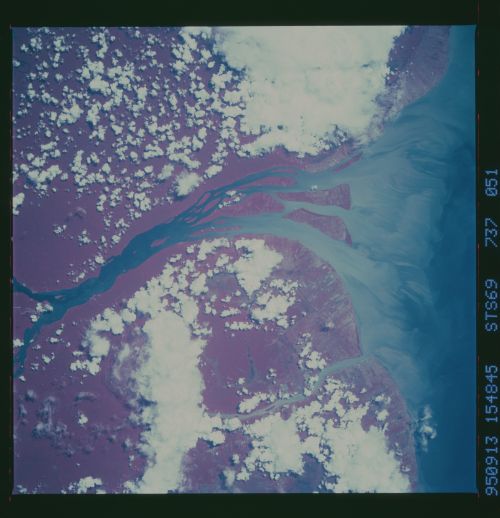
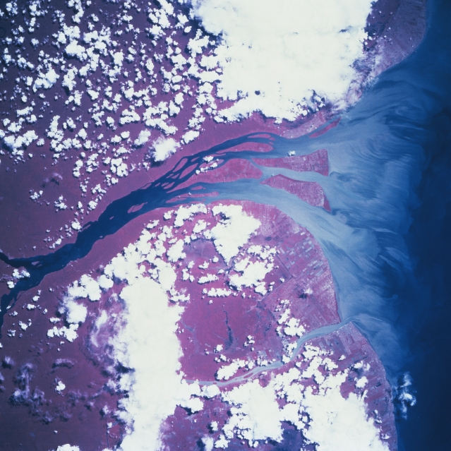
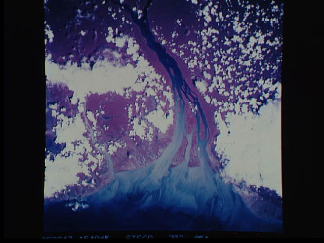
Image Caption: STS069-737-51 Essequibo River, Guyana September 1995
Even though cloud cover obscures approximately fifty percent of the landscape in this image, the delta of the Essequibo River is almost cloud free (near center). The light-colored, streamlining effect at the mouth of the river vividly depicts the sediment pattern and extent of its discharge into the Atlantic Ocean. East of this broad estuary, the smaller sediment plume of the Demerara River is visible as it also empties northward into the Atlantic Ocean (lower right quadrant). Georgetown, Guyana's capital city and chief port, is located along the northeast shore of the larger estuary. Approximately 90 percent of Guyana's estimated 750,000 people live along the agriculturally rich coastal plain. Linear patterns along the coast reflect land ownership boundaries (field boundaries, mainly sugar and cotton plantations) and numerous canals that interconnect the coastal plains. The extensive area of deep red colors inland in this color infrared image shows the tropical rainforest zone that characterizes most of the interior of Guyana.
Even though cloud cover obscures approximately fifty percent of the landscape in this image, the delta of the Essequibo River is almost cloud free (near center). The light-colored, streamlining effect at the mouth of the river vividly depicts the sediment pattern and extent of its discharge into the Atlantic Ocean. East of this broad estuary, the smaller sediment plume of the Demerara River is visible as it also empties northward into the Atlantic Ocean (lower right quadrant). Georgetown, Guyana's capital city and chief port, is located along the northeast shore of the larger estuary. Approximately 90 percent of Guyana's estimated 750,000 people live along the agriculturally rich coastal plain. Linear patterns along the coast reflect land ownership boundaries (field boundaries, mainly sugar and cotton plantations) and numerous canals that interconnect the coastal plains. The extensive area of deep red colors inland in this color infrared image shows the tropical rainforest zone that characterizes most of the interior of Guyana.
