STS069-729-19
| NASA Photo ID | STS069-729-19 |
| Focal Length | 100mm |
| Date taken | 1995.09.11 |
| Time taken | 20:29:55 GMT |
Resolutions offered for this image:
3904 x 3936 pixels 634 x 639 pixels 5700 x 5900 pixels 500 x 518 pixels 640 x 480 pixels 960 x 970 pixels 450 x 450 pixels 960 x 970 pixels
3904 x 3936 pixels 634 x 639 pixels 5700 x 5900 pixels 500 x 518 pixels 640 x 480 pixels 960 x 970 pixels 450 x 450 pixels 960 x 970 pixels


Cloud masks available for this image:
Spacecraft nadir point: 24.0° N, 159.0° W
Photo center point: 22.0° N, 159.5° W
Photo center point by machine learning:
Photo center point: 22.0° N, 159.5° W
Photo center point by machine learning:
Nadir to Photo Center: South
Spacecraft Altitude: 215 nautical miles (398km)
Camera: | Hasselblad |
Focal Length: | 100mm |
Camera Tilt: | 30 degrees |
Format: | 5046: Kodak, natural color positive, Lumiere 100/5046, ASA 100, standard base |
Film Exposure: | Normal |
| Additional Information | |
| Width | Height | Annotated | Cropped | Purpose | Links |
|---|---|---|---|---|---|
| 3904 pixels | 3936 pixels | No | No | Earth From Space collection | Download Image |
| 634 pixels | 639 pixels | No | No | Earth From Space collection | Download Image |
| 5700 pixels | 5900 pixels | No | No | Download Image | |
| 500 pixels | 518 pixels | No | No | Download Image | |
| 640 pixels | 480 pixels | No | No | Download Image | |
| 960 pixels | 970 pixels | Yes | No | Download Image | |
| 450 pixels | 450 pixels | Download Image | |||
| 960 pixels | 970 pixels | Download Image |
Download Packaged File
Download a Google Earth KML for this Image
View photo footprint information
Download a GeoTIFF for this photo
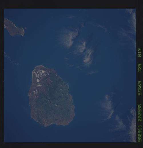
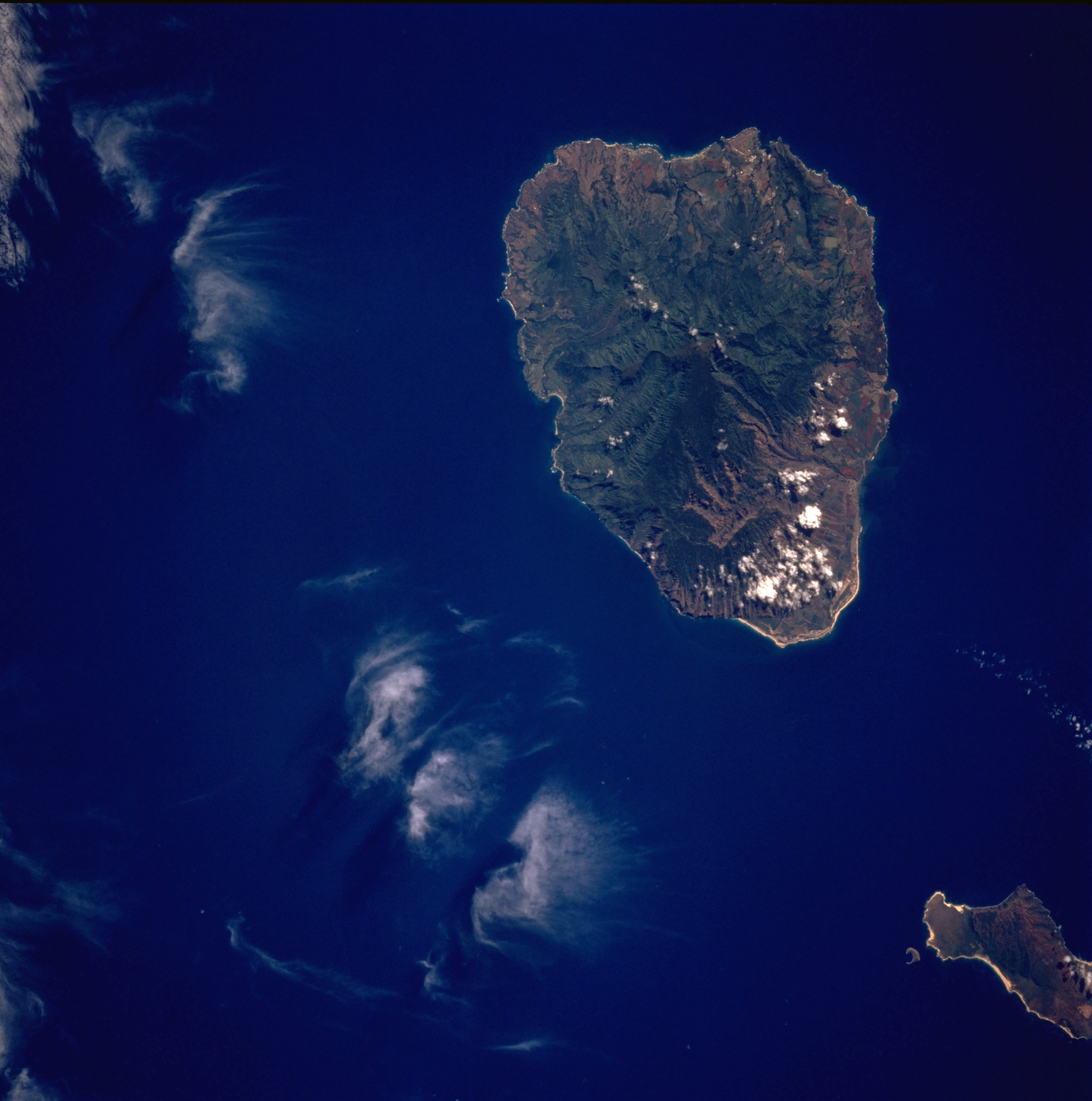
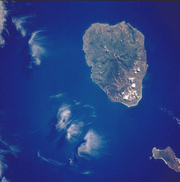
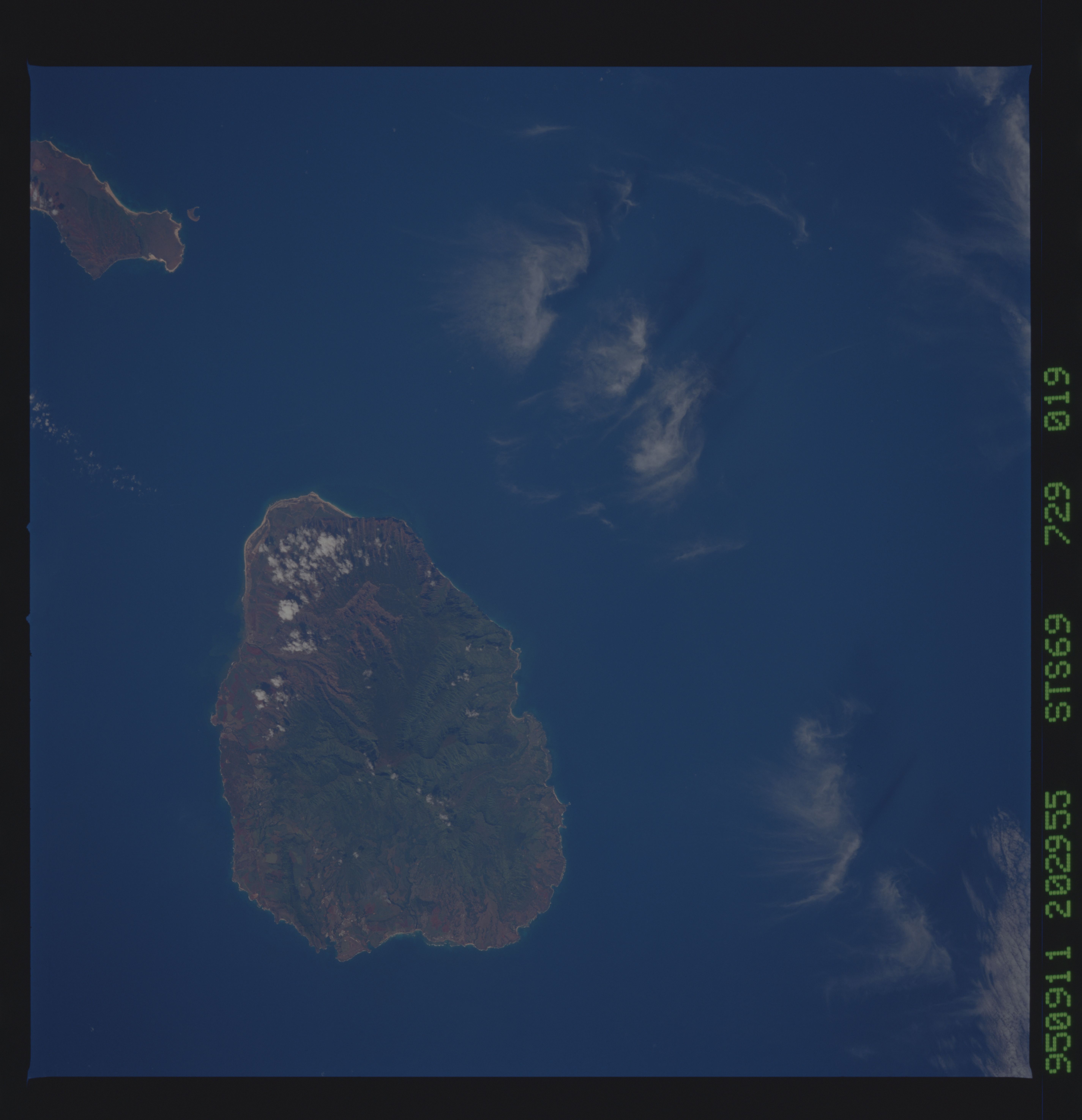
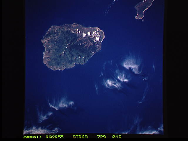
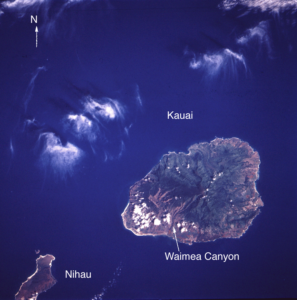
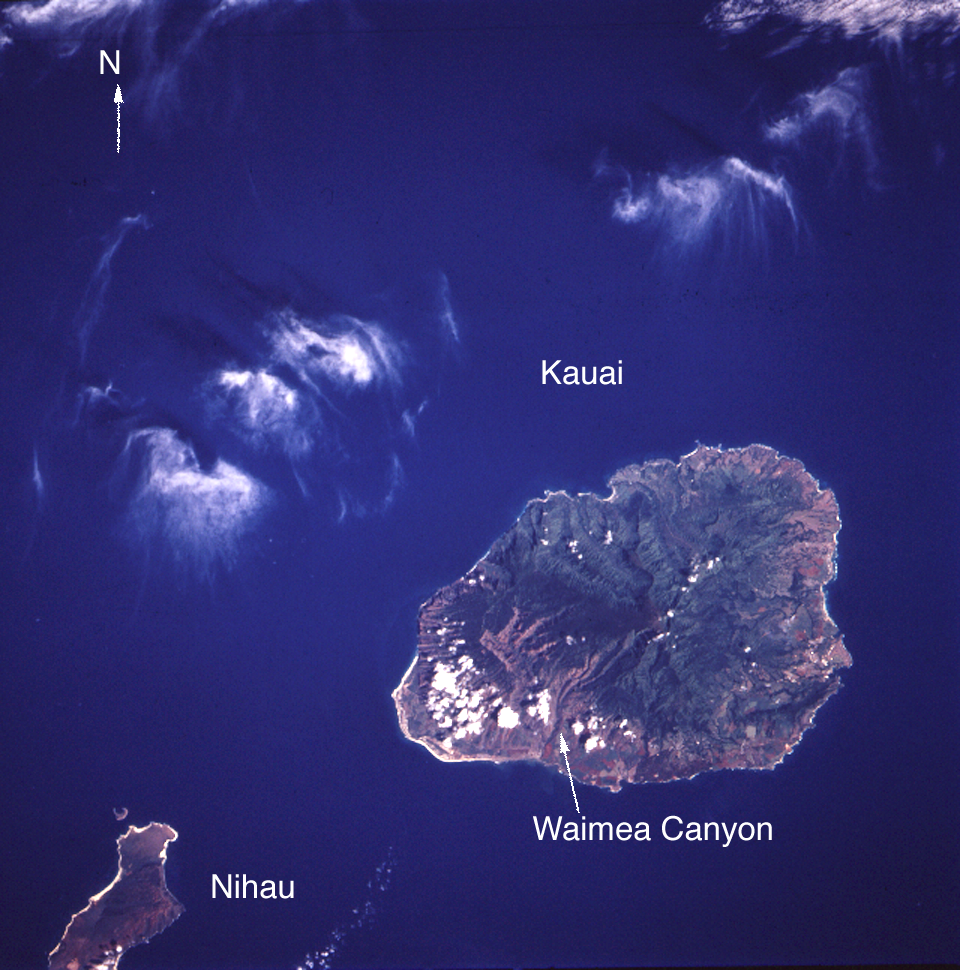
Image Caption: STS069-729-019 Kauai, Hawaii, U.S.A. September 1995
Kauai, more than 5 million years old, is the oldest of the larger Hawaiian Islands. Waialeale Peak [5148 feet (1569 meters)], the wettest place on Earth, receives more than 500 inches (1270 centimeters) of precipitation each year. Because of excessive precipitation, much of the island (especially where humans and animals have modified the natural environment through agriculture and grazing) now faces the challenge of erosion. Gullied erosion has been documented along the Na Pali Coast of northwest Kauai where overgrazing has produced steep, barren slopes. The large quantity of rainfall has shaped beautiful vegetated canyons and valleys. Many conservationists are now studying the erosion problems to determine what balance can be maintained to protect and preserve the delicate flora and fauna species. The northeast half of Niihau is visible in the lower right corner of the photograph.
Kauai, more than 5 million years old, is the oldest of the larger Hawaiian Islands. Waialeale Peak [5148 feet (1569 meters)], the wettest place on Earth, receives more than 500 inches (1270 centimeters) of precipitation each year. Because of excessive precipitation, much of the island (especially where humans and animals have modified the natural environment through agriculture and grazing) now faces the challenge of erosion. Gullied erosion has been documented along the Na Pali Coast of northwest Kauai where overgrazing has produced steep, barren slopes. The large quantity of rainfall has shaped beautiful vegetated canyons and valleys. Many conservationists are now studying the erosion problems to determine what balance can be maintained to protect and preserve the delicate flora and fauna species. The northeast half of Niihau is visible in the lower right corner of the photograph.
