STS069-723-32

| NASA Photo ID | STS069-723-32 |
| Focal Length | 40mm |
| Date taken | 1995.09.10 |
| Time taken | 12:05:57 GMT |

Cloud masks available for this image:
Spacecraft nadir point: 28.5° N, 50.9° W
Photo center point:
Photo center point by machine learning:
Photo center point:
Photo center point by machine learning:
Nadir to Photo Center:
Spacecraft Altitude: 200 nautical miles (370km)
Country or Geographic Name: | ATLANTIC OCEAN |
Features: | PAN-HURRICANE, REFL. |
| Features Found Using Machine Learning: | |
Cloud Cover Percentage: | 50 (26-50)% |
Sun Elevation Angle: | 38° |
Sun Azimuth: | 107° |
Camera: | Hasselblad |
Focal Length: | 40mm |
Camera Tilt: | High Oblique |
Format: | 5046: Kodak, natural color positive, Lumiere 100/5046, ASA 100, standard base |
Film Exposure: | Normal |
| Additional Information | |
| Width | Height | Annotated | Cropped | Purpose | Links |
|---|---|---|---|---|---|
| 5700 pixels | 5900 pixels | No | No | Download Image | |
| 500 pixels | 518 pixels | No | No | Download Image | |
| 640 pixels | 480 pixels | No | No | Download Image |
Download Packaged File
Download a Google Earth KML for this Image
View photo footprint information
Download a GeoTIFF for this photo
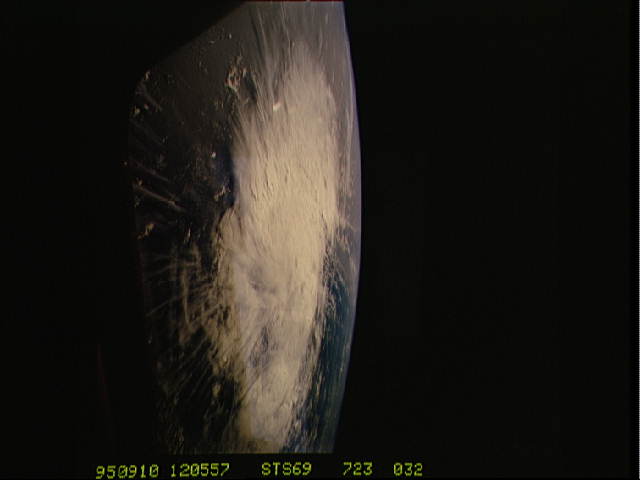
Image Caption: Hurricane Luis
Tropical Depression Thirteen formed near 12 degrees North and 28
degrees West on the 28th of August. Luis reached hurricane category 4
strength three days later as it slowly moved west toward the Leeward
islands. The storm slowly weakened after that and moved north were it
dissipated after making landfall in Nova Scotia, bringing high surf
and heavy rainfall. Before the storm came to an end it did affect the
Leeward Islands and Bermuda. Major damage was reported on the Leeward
Islands, from Antigua to St. Martin, and sixteen deaths were blamed on
this powerful storm. The U.S. weather reporting station in Antigua
reported a wind gust of 146 miles per hour just before their wind
recorder broke as the hurricane eye was just off shore.
