STS068-273-38
| NASA Photo ID | STS068-273-38 |
| Focal Length | 250mm |
| Date taken | 1994.10.03 |
| Time taken | 21:09:31 GMT |
Resolutions offered for this image:
3904 x 3872 pixels 639 x 634 pixels 5700 x 5900 pixels 500 x 518 pixels 640 x 480 pixels
3904 x 3872 pixels 639 x 634 pixels 5700 x 5900 pixels 500 x 518 pixels 640 x 480 pixels


Cloud masks available for this image:
Spacecraft nadir point: 43.4° N, 125.6° W
Photo center point: 43.0° N, 124.5° W
Photo center point by machine learning:
Photo center point: 43.0° N, 124.5° W
Photo center point by machine learning:
Nadir to Photo Center: East
Spacecraft Altitude: 117 nautical miles (217km)
Country or Geographic Name: | USA-OREGON |
Features: | CAPE BLANCO |
| Features Found Using Machine Learning: | |
Cloud Cover Percentage: | 0 (no clouds present) |
Sun Elevation Angle: | 41° |
Sun Azimuth: | 199° |
Camera: | Hasselblad |
Focal Length: | 250mm |
Camera Tilt: | 31 degrees |
Format: | 5046: Kodak, natural color positive, Lumiere 100/5046, ASA 100, standard base |
Film Exposure: | Normal |
| Additional Information | |
| Width | Height | Annotated | Cropped | Purpose | Links |
|---|---|---|---|---|---|
| 3904 pixels | 3872 pixels | No | No | Earth From Space collection | Download Image |
| 639 pixels | 634 pixels | No | No | Earth From Space collection | Download Image |
| 5700 pixels | 5900 pixels | No | No | Download Image | |
| 500 pixels | 518 pixels | No | No | Download Image | |
| 640 pixels | 480 pixels | No | No | Download Image |
Download Packaged File
Download a Google Earth KML for this Image
View photo footprint information
Download a GeoTIFF for this photo
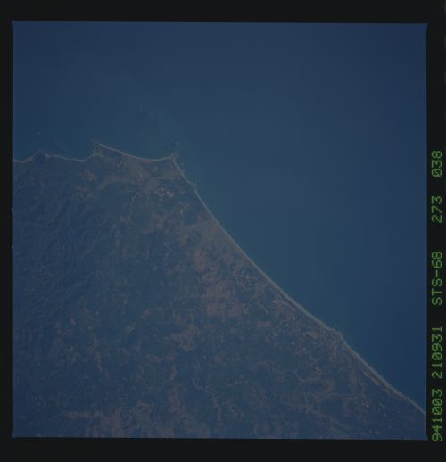
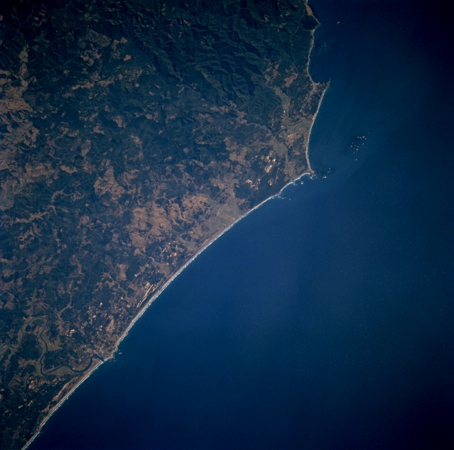
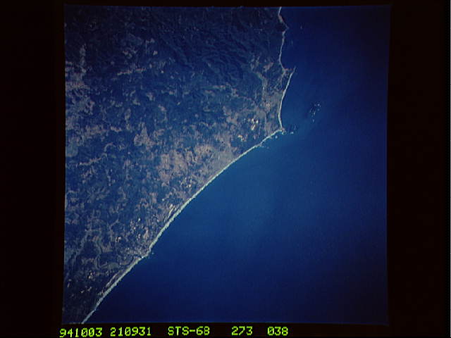
Image Caption: STS068-273-038 Cape Blanco, Oregon, U.S.A. October 1994
Cape Blanco, the westernmost point in the contiguous United States, is featured in this low-oblique, south-southeasterly-looking photograph. Known as one of the windiest places in the western United States, Cape Blanco has registered winds of 184 miles (296 kilometers) an hour. Barely discernible north and west of the cape is a small, rocky arc. Visible are the forest-covered Coast Ranges and the Coquille River as it enters the Pacific Ocean.
Cape Blanco, the westernmost point in the contiguous United States, is featured in this low-oblique, south-southeasterly-looking photograph. Known as one of the windiest places in the western United States, Cape Blanco has registered winds of 184 miles (296 kilometers) an hour. Barely discernible north and west of the cape is a small, rocky arc. Visible are the forest-covered Coast Ranges and the Coquille River as it enters the Pacific Ocean.
