STS068-247-79
| NASA Photo ID | STS068-247-79 |
| Focal Length | 250mm |
| Date taken | 1994.10.09 |
| Time taken | 17:38:12 GMT |
Resolutions offered for this image:
5276 x 5276 pixels 640 x 640 pixels 5700 x 5900 pixels 500 x 518 pixels 640 x 480 pixels
5276 x 5276 pixels 640 x 640 pixels 5700 x 5900 pixels 500 x 518 pixels 640 x 480 pixels


Cloud masks available for this image:
Spacecraft nadir point: 34.6° N, 95.7° W
Photo center point: 34.0° N, 96.5° W
Photo center point by machine learning:
Photo center point: 34.0° N, 96.5° W
Photo center point by machine learning:
Nadir to Photo Center: Southwest
Spacecraft Altitude: 111 nautical miles (206km)
Country or Geographic Name: | USA-OKLAHOMA |
Features: | LAKE TEXOMA, RED R., SOFT |
| Features Found Using Machine Learning: | |
Cloud Cover Percentage: | 0 (no clouds present) |
Sun Elevation Angle: | 48° |
Sun Azimuth: | 168° |
Camera: | Hasselblad |
Focal Length: | 250mm |
Camera Tilt: | 28 degrees |
Format: | 5046: Kodak, natural color positive, Lumiere 100/5046, ASA 100, standard base |
Film Exposure: | Out of Focus |
| Additional Information | |
| Width | Height | Annotated | Cropped | Purpose | Links |
|---|---|---|---|---|---|
| 5276 pixels | 5276 pixels | No | No | Earth From Space collection | Download Image |
| 640 pixels | 640 pixels | No | No | Earth From Space collection | Download Image |
| 5700 pixels | 5900 pixels | No | No | Download Image | |
| 500 pixels | 518 pixels | No | No | Download Image | |
| 640 pixels | 480 pixels | No | No | Download Image |
Download Packaged File
Download a Google Earth KML for this Image
View photo footprint information
Download a GeoTIFF for this photo
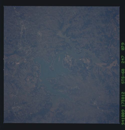
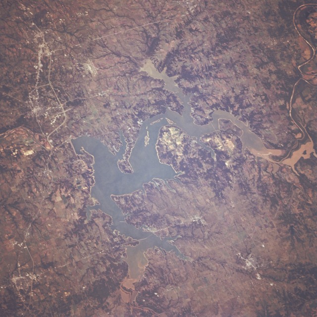
Image Caption: STS068-247-079 Lake Texoma Area, Oklahoma and Texas, U.S.A. October 1994
This south-looking, low-oblique photograph captures Lake Texoma, created when Denison Dam was built after World War II. Located on the Red River between Oklahoma and Texas, Lake Texoma serves the surrounding region as a source of hydroelectricity, irrigation, and recreation. The Red River, the southernmost of the large tributaries of the Mississippi River, [1222 miles (1966 kilometers) long] rises in eastern New Mexico; flows across the Texas Panhandle in a southeasterly direction; turns south near Fulton, Arkansas; continues past Shreveport, the head of navigation for the Red River; and joins the Mississippi River approximately 30 miles (48 kilometers) north of Baton Rouge, Louisiana. The rich, red clay soils of the prime agricultural region around Lake Texoma can be seen in the sediment entering the lake from the west and from the north. Visible near the northeast corner of the photograph is the small city of Durant, Oklahoma, a commercial and processing center for agricultural products such as peanuts, winter wheat, cotton, and cattle. Just south of Denison Dam is the small city of Denison, Texas, birthplace of Dwight D. Eisenhower, 34th President of the United States. Industries in Denison include textile mills, garment factories, and agricultural processing plants for peanuts, grapes, pecans, and cotton. Ten miles (16 kilometers) south of Denison (observable near the southeast corner of the photograph) is the small city of Sherman, which is 60 miles (97 kilometers) north-northeast of Dallas. The runways of Perrin Air Force Base can be seen northwest of the city. Originally on a stagecoach route, the city is now a highway and railroad junction. Industries include flour and feed mills, cotton, textile factories, business machines, instruments, and surgical dressings.
This south-looking, low-oblique photograph captures Lake Texoma, created when Denison Dam was built after World War II. Located on the Red River between Oklahoma and Texas, Lake Texoma serves the surrounding region as a source of hydroelectricity, irrigation, and recreation. The Red River, the southernmost of the large tributaries of the Mississippi River, [1222 miles (1966 kilometers) long] rises in eastern New Mexico; flows across the Texas Panhandle in a southeasterly direction; turns south near Fulton, Arkansas; continues past Shreveport, the head of navigation for the Red River; and joins the Mississippi River approximately 30 miles (48 kilometers) north of Baton Rouge, Louisiana. The rich, red clay soils of the prime agricultural region around Lake Texoma can be seen in the sediment entering the lake from the west and from the north. Visible near the northeast corner of the photograph is the small city of Durant, Oklahoma, a commercial and processing center for agricultural products such as peanuts, winter wheat, cotton, and cattle. Just south of Denison Dam is the small city of Denison, Texas, birthplace of Dwight D. Eisenhower, 34th President of the United States. Industries in Denison include textile mills, garment factories, and agricultural processing plants for peanuts, grapes, pecans, and cotton. Ten miles (16 kilometers) south of Denison (observable near the southeast corner of the photograph) is the small city of Sherman, which is 60 miles (97 kilometers) north-northeast of Dallas. The runways of Perrin Air Force Base can be seen northwest of the city. Originally on a stagecoach route, the city is now a highway and railroad junction. Industries include flour and feed mills, cotton, textile factories, business machines, instruments, and surgical dressings.
