STS068-214-67
| NASA Photo ID | STS068-214-67 |
| Focal Length | 250mm |
| Date taken | 1994.10.01 |
| Time taken | 04:01:01 GMT |
Resolutions offered for this image:
4062 x 4062 pixels 640 x 640 pixels 5700 x 5900 pixels 500 x 518 pixels 640 x 480 pixels
4062 x 4062 pixels 640 x 640 pixels 5700 x 5900 pixels 500 x 518 pixels 640 x 480 pixels


Cloud masks available for this image:
Spacecraft nadir point: 43.3° N, 147.4° E
Photo center point: 43.5° N, 145.0° E
Photo center point by machine learning:
Photo center point: 43.5° N, 145.0° E
Photo center point by machine learning:
Nadir to Photo Center: West
Spacecraft Altitude: 118 nautical miles (219km)
Country or Geographic Name: | JAPAN |
Features: | KOKKAIDO, NEMURO BAY, AGR |
| Features Found Using Machine Learning: | |
Cloud Cover Percentage: | 5 (1-10)% |
Sun Elevation Angle: | 36° |
Sun Azimuth: | 219° |
Camera: | Hasselblad |
Focal Length: | 250mm |
Camera Tilt: | 51 degrees |
Format: | 5046: Kodak, natural color positive, Lumiere 100/5046, ASA 100, standard base |
Film Exposure: | Normal |
| Additional Information | |
| Width | Height | Annotated | Cropped | Purpose | Links |
|---|---|---|---|---|---|
| 4062 pixels | 4062 pixels | No | No | Earth From Space collection | Download Image |
| 640 pixels | 640 pixels | No | No | Earth From Space collection | Download Image |
| 5700 pixels | 5900 pixels | No | No | Download Image | |
| 500 pixels | 518 pixels | No | No | Download Image | |
| 640 pixels | 480 pixels | No | No | Download Image |
Download Packaged File
Download a Google Earth KML for this Image
View photo footprint information
Download a GeoTIFF for this photo
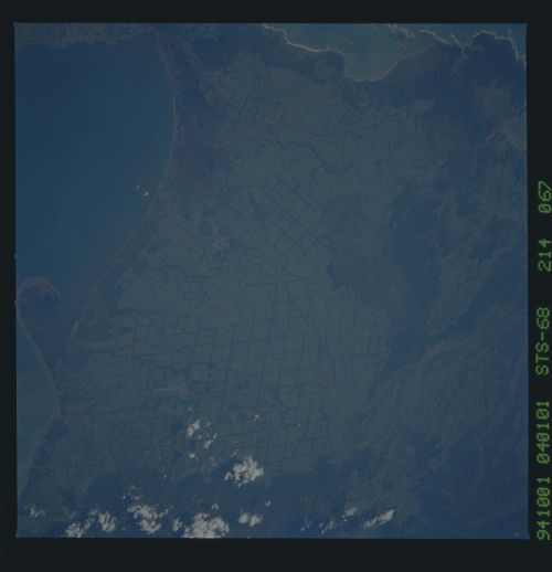
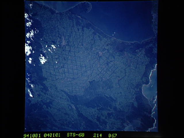
Image Caption: STS068-214-067 Coastal Plains, Hokkaido Island, Japan October 1994
The coastal plains of east, southeast Hokkaido are visible in this generally west-looking view. The lighter colored, gridded (dark, intersecting lines) landscape, has been produced by a methodical land clearing operation, where terrain was once forested, now the land is being used for agricultural purposes. Notice that several drainage patterns can be traced across the light-colored fields. The drainage pattern shows up as dark meandering features because trees (vegetation) still outline the stream channels. A series of coastal wetlands including several estuaries and bordering swamplands (darker coastal regions) are visible. There is a large sand spit that extends eastward into the Nemuro Strait (bottom center). The darker landscapes inland are forested low-lying drainage basins or forested mountain slopes that are partially obscured by clouds (along the right edge).
The coastal plains of east, southeast Hokkaido are visible in this generally west-looking view. The lighter colored, gridded (dark, intersecting lines) landscape, has been produced by a methodical land clearing operation, where terrain was once forested, now the land is being used for agricultural purposes. Notice that several drainage patterns can be traced across the light-colored fields. The drainage pattern shows up as dark meandering features because trees (vegetation) still outline the stream channels. A series of coastal wetlands including several estuaries and bordering swamplands (darker coastal regions) are visible. There is a large sand spit that extends eastward into the Nemuro Strait (bottom center). The darker landscapes inland are forested low-lying drainage basins or forested mountain slopes that are partially obscured by clouds (along the right edge).
