STS068-206-40
| NASA Photo ID | STS068-206-40 |
| Focal Length | 250mm |
| Date taken | 1994.10.03 |
| Time taken | 04:49:32 GMT |
Resolutions offered for this image:
4096 x 4096 pixels 640 x 640 pixels 5700 x 5900 pixels 500 x 518 pixels 640 x 480 pixels 800 x 800 pixels
4096 x 4096 pixels 640 x 640 pixels 5700 x 5900 pixels 500 x 518 pixels 640 x 480 pixels 800 x 800 pixels

Cloud masks available for this image:
Spacecraft nadir point: 50.9° N, 108.4° E
Photo center point: 52.0° N, 106.5° E
Photo center point by machine learning:
Photo center point: 52.0° N, 106.5° E
Photo center point by machine learning:
Nadir to Photo Center: Northwest
Spacecraft Altitude: 117 nautical miles (217km)
Country or Geographic Name: | RUSSIAN FEDERATION |
Features: | SELENGA RIVER DELTA |
| Features Found Using Machine Learning: | |
Cloud Cover Percentage: | 0 (no clouds present) |
Sun Elevation Angle: | 35° |
Sun Azimuth: | 184° |
Camera: | Hasselblad |
Focal Length: | 250mm |
Camera Tilt: | 48 degrees |
Format: | 2443: Kodak Aerochrome 2443, color IR, thin base, EA-5 process thru June 1999, E-6 process afterward |
Film Exposure: | Normal |
| Additional Information | |
| Width | Height | Annotated | Cropped | Purpose | Links |
|---|---|---|---|---|---|
| 4096 pixels | 4096 pixels | No | No | Earth From Space collection | Download Image |
| 640 pixels | 640 pixels | No | No | Earth From Space collection | Download Image |
| 5700 pixels | 5900 pixels | No | No | Download Image | |
| 500 pixels | 518 pixels | No | No | Download Image | |
| 640 pixels | 480 pixels | No | No | Download Image | |
| 800 pixels | 800 pixels | Yes | No | Download Image |
Download Packaged File
Download a Google Earth KML for this Image
View photo footprint information
Download a GeoTIFF for this photo
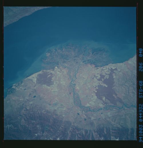
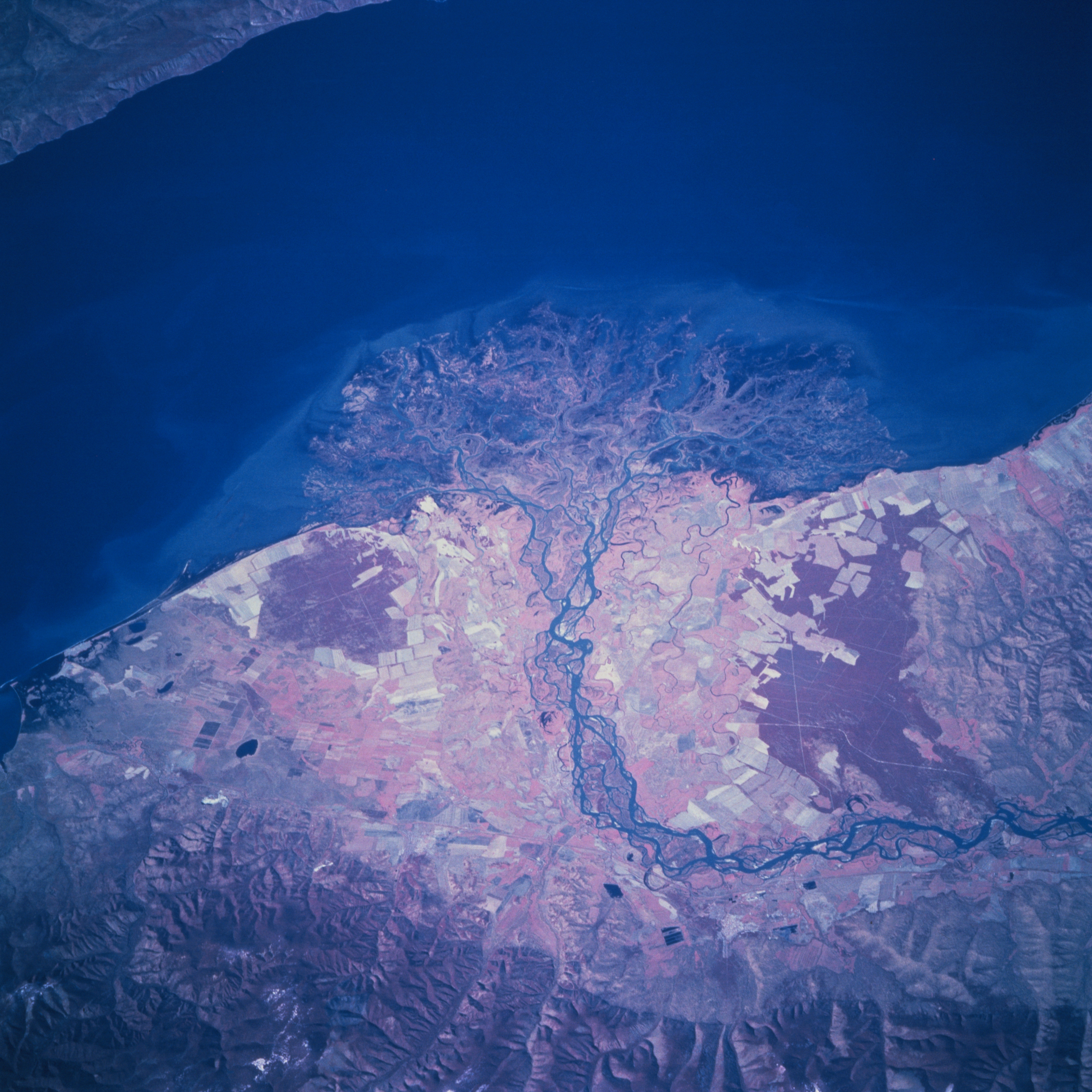
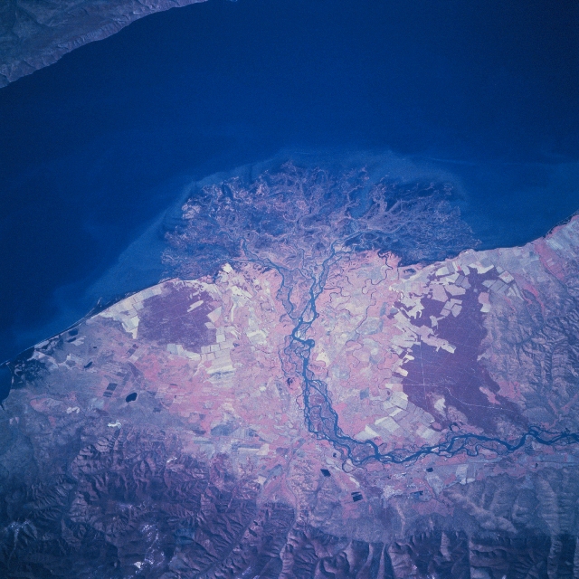
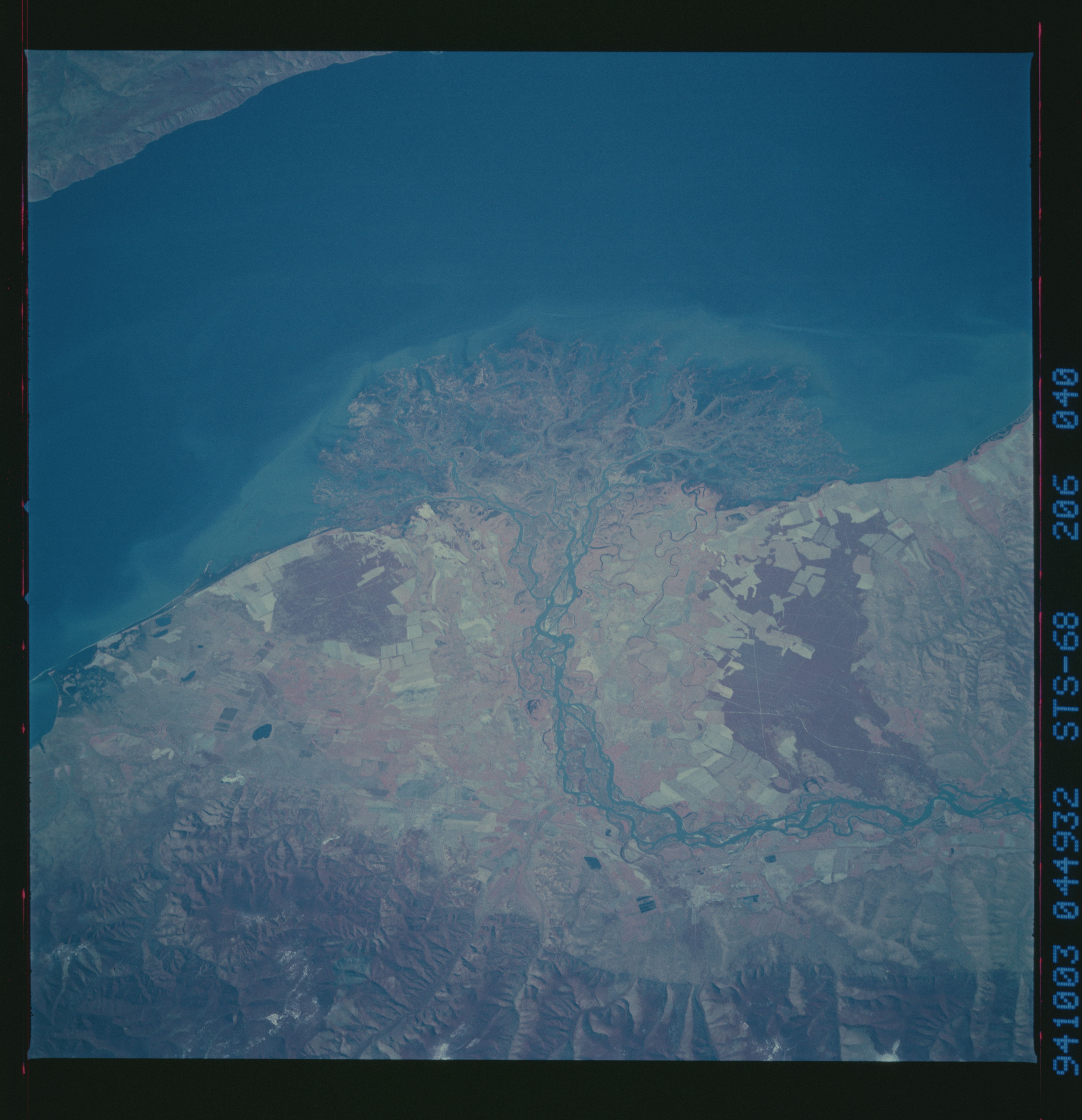
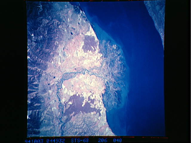
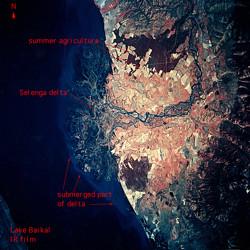
Image Caption: STS068-206-040 Selenga River Delta, Russia October 1994
The Selenga River has deposited a sizeable delta along the southwest side of Lake Baykal. While over 300 streams flow into Lake Baykal, the Selenga River is the largest single river system that enters the lake. The Selenga along with many of its tributary streams and valleys provide transportation routes that connect Russia with Mongolia and China. Over 50 percent of the pollution that enters Lake Baykal enters through the Selenga River from as far away as Mongolia. Considering the depth of Lake Baykal (maximum depth 5710 feet-1741 meters) the amount of eroded sediment that has created such a large delta is impressive. The delta is a maze of interconnected waterways and wetland as expressed by the intermixing of colors and shapes (center of image). The dark red areas (green vegetation on this color infrared image) north and south of the braided channels of the delta of the Selenga River are forested land. The lighter-colored areas (towards center of image) show the extent of the agricultural activities (angular-looking field patterns) on the fertile delta. The delta area also provides an extensive wetland habitat for many species of fish, waterfowl, and mammals. The northern slopes of the rugged Khamar-Daban Mountains are visible along the bottom of the image.
The Selenga River has deposited a sizeable delta along the southwest side of Lake Baykal. While over 300 streams flow into Lake Baykal, the Selenga River is the largest single river system that enters the lake. The Selenga along with many of its tributary streams and valleys provide transportation routes that connect Russia with Mongolia and China. Over 50 percent of the pollution that enters Lake Baykal enters through the Selenga River from as far away as Mongolia. Considering the depth of Lake Baykal (maximum depth 5710 feet-1741 meters) the amount of eroded sediment that has created such a large delta is impressive. The delta is a maze of interconnected waterways and wetland as expressed by the intermixing of colors and shapes (center of image). The dark red areas (green vegetation on this color infrared image) north and south of the braided channels of the delta of the Selenga River are forested land. The lighter-colored areas (towards center of image) show the extent of the agricultural activities (angular-looking field patterns) on the fertile delta. The delta area also provides an extensive wetland habitat for many species of fish, waterfowl, and mammals. The northern slopes of the rugged Khamar-Daban Mountains are visible along the bottom of the image.
