STS068-174-154
| NASA Photo ID | STS068-174-154 |
| Focal Length | 250mm |
| Date taken | 1994.10.06 |
| Time taken | 18:39:46 GMT |

Cloud masks available for this image:
Spacecraft nadir point: 48.3° N, 113.8° W
Photo center point: 46.5° N, 117.0° W
Photo center point by machine learning:
Photo center point: 46.5° N, 117.0° W
Photo center point by machine learning:
Nadir to Photo Center: Southwest
Spacecraft Altitude: 115 nautical miles (213km)
Country or Geographic Name: | USA-IDAHO |
Features: | SNAKE R, LEWISTON AREA |
| Features Found Using Machine Learning: | |
Cloud Cover Percentage: | 5 (1-10)% |
Sun Elevation Angle: | 36° |
Sun Azimuth: | 167° |
Camera: | Linhof |
Focal Length: | 250mm |
Camera Tilt: | Low Oblique |
Format: | 5048: Kodak, natural color positive, Lumiere 100x/5048, ASA 100x, standard base |
Film Exposure: | Normal |
| Additional Information | |
| Width | Height | Annotated | Cropped | Purpose | Links |
|---|---|---|---|---|---|
| 5152 pixels | 4096 pixels | No | No | Earth From Space collection | Download Image |
| 640 pixels | 508 pixels | No | No | Earth From Space collection | Download Image |
| 640 pixels | 480 pixels | No | No | ISD 1 | Download Image |
Download Packaged File
Download a Google Earth KML for this Image
View photo footprint information
Download a GeoTIFF for this photo
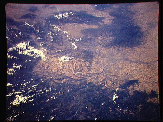
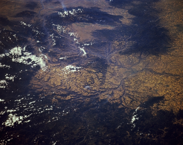
Image Caption: STS068-174-154 Snake River, Lewiston, and the Clearwater Mountains, Idaho and Oregon, U.S.A October 1994
The Snake River is featured in this south-southwest-looking, low-oblique photograph as it travels from the west (right center) to the southeast at Lewiston, Idaho (midway between the center and right center of the photograph). As it winds to the southeast, the river proceeds through Hells Canyon National Recreation Area on the Idaho-Oregon border east of the rugged Wallowa Mountains near the top center of the photograph. Extending approximately 125 miles (200 kilometers) in a north-south orientation, Hells Canyon reaches a maximum depth of 7900 feet (2410 meters), making it one of the deepest canyons in the world. Visible are the forested Blue Mountains of Oregon and Washington near the upper right of the photograph and the forest-covered Clearwater Mountains, partially obscured by clouds, from the bottom right to near the top left corner of the photograph. The southeastern portion of the Columbia Plateau, with many agricultural field patterns, is discernible from the left of center to the right center of the photograph.
The Snake River is featured in this south-southwest-looking, low-oblique photograph as it travels from the west (right center) to the southeast at Lewiston, Idaho (midway between the center and right center of the photograph). As it winds to the southeast, the river proceeds through Hells Canyon National Recreation Area on the Idaho-Oregon border east of the rugged Wallowa Mountains near the top center of the photograph. Extending approximately 125 miles (200 kilometers) in a north-south orientation, Hells Canyon reaches a maximum depth of 7900 feet (2410 meters), making it one of the deepest canyons in the world. Visible are the forested Blue Mountains of Oregon and Washington near the upper right of the photograph and the forest-covered Clearwater Mountains, partially obscured by clouds, from the bottom right to near the top left corner of the photograph. The southeastern portion of the Columbia Plateau, with many agricultural field patterns, is discernible from the left of center to the right center of the photograph.
