STS068-174-121
| NASA Photo ID | STS068-174-121 |
| Focal Length | 250mm |
| Date taken | 1994.10.06 |
| Time taken | 17:09:12 GMT |

Cloud masks available for this image:
Spacecraft nadir point: 52.2° N, 100.7° W
Photo center point: 53.5° N, 100.5° W
Photo center point by machine learning:
Photo center point: 53.5° N, 100.5° W
Photo center point by machine learning:
Nadir to Photo Center: North
Spacecraft Altitude: 115 nautical miles (213km)
Country or Geographic Name: | CANADA-M |
Features: | CEDAR LAKE/RESERVOIR |
| Features Found Using Machine Learning: | |
Cloud Cover Percentage: | 0 (no clouds present) |
Sun Elevation Angle: | 30° |
Sun Azimuth: | 156° |
Camera: | Linhof |
Focal Length: | 250mm |
Camera Tilt: | 34 degrees |
Format: | 5048: Kodak, natural color positive, Lumiere 100x/5048, ASA 100x, standard base |
Film Exposure: | Normal |
| Additional Information | |
| Width | Height | Annotated | Cropped | Purpose | Links |
|---|---|---|---|---|---|
| 5120 pixels | 4096 pixels | No | No | Earth From Space collection | Download Image |
| 640 pixels | 512 pixels | No | No | Earth From Space collection | Download Image |
| 640 pixels | 480 pixels | No | No | ISD 1 | Download Image |
Download Packaged File
Download a Google Earth KML for this Image
View photo footprint information
Download a GeoTIFF for this photo
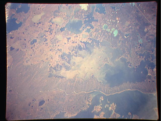
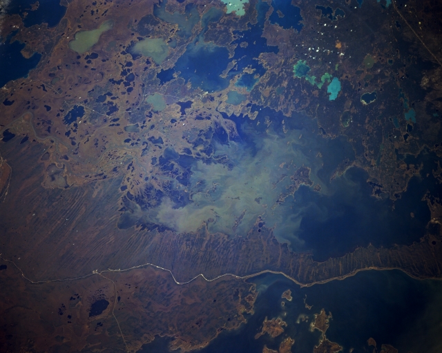
Image Caption: STS068-174-121 Cedar Lake, Manitoba, Canada October 1994
The Saskatchewan River manages to flow through the maze of small lakes and eventually Cedar Lake (large lake in center of the image) before the river empties into the northwest side of Lake Winnipeg in the upper right side of the photograph. The Saskatchewan River was dammed in 1968 to form Cedar Lake reservoir 2.5 miles (4 kilometers) above Grand Rapids. Due to the composition of the limestone formation in the area, 99909 tons of cement were used to grout the forebay of the reservoir. A dike visible on the shore of Lake Winnipegosis was constructed to keep the two water bodies separate. The large lake dotted with islands at the bottom right is the northern edge of Lake Winnipegosis. The overall landscape is swampy, flat terrain. A small section of Highway 6 is visible (upper right corner); Highway 60 runs laterally across the picture between the two large lakes, and a section of highway 10 connects with the western end of highway 60. It is interesting to note the different water colors in many of the lakes and also notice the unusual striated pattern in the marshy area north of Highway 60.
The Saskatchewan River manages to flow through the maze of small lakes and eventually Cedar Lake (large lake in center of the image) before the river empties into the northwest side of Lake Winnipeg in the upper right side of the photograph. The Saskatchewan River was dammed in 1968 to form Cedar Lake reservoir 2.5 miles (4 kilometers) above Grand Rapids. Due to the composition of the limestone formation in the area, 99909 tons of cement were used to grout the forebay of the reservoir. A dike visible on the shore of Lake Winnipegosis was constructed to keep the two water bodies separate. The large lake dotted with islands at the bottom right is the northern edge of Lake Winnipegosis. The overall landscape is swampy, flat terrain. A small section of Highway 6 is visible (upper right corner); Highway 60 runs laterally across the picture between the two large lakes, and a section of highway 10 connects with the western end of highway 60. It is interesting to note the different water colors in many of the lakes and also notice the unusual striated pattern in the marshy area north of Highway 60.
