STS068-170-55B
| NASA Photo ID | STS068-170-55B |
| Focal Length | 250mm |
| Date taken | 1994.10.04 |
| Time taken | 19:18:11 GMT |

Cloud masks available for this image:
Spacecraft nadir point: 51.2° N, 118.9° W
Photo center point: 51.0° N, 120.0° W
Photo center point by machine learning:
Photo center point: 51.0° N, 120.0° W
Photo center point by machine learning:
Nadir to Photo Center: West
Spacecraft Altitude: 116 nautical miles (215km)
Country or Geographic Name: | CANADA-BC |
Features: | KAMLOOPS L., FORESTS, R. |
| Features Found Using Machine Learning: | |
Cloud Cover Percentage: | 0 (no clouds present) |
Sun Elevation Angle: | 34° |
Sun Azimuth: | 172° |
Camera: | Linhof |
Focal Length: | 250mm |
Camera Tilt: | 30 degrees |
Format: | 5048: Kodak, natural color positive, Lumiere 100x/5048, ASA 100x, standard base |
Film Exposure: | Normal |
| Additional Information | |
| Width | Height | Annotated | Cropped | Purpose | Links |
|---|---|---|---|---|---|
| 5184 pixels | 4096 pixels | No | No | Earth From Space collection | Download Image |
| 640 pixels | 505 pixels | No | No | Earth From Space collection | Download Image |
| 640 pixels | 480 pixels | No | No | ISD 1 | Download Image |
Download Packaged File
Download a Google Earth KML for this Image
View photo footprint information
Download a GeoTIFF for this photo
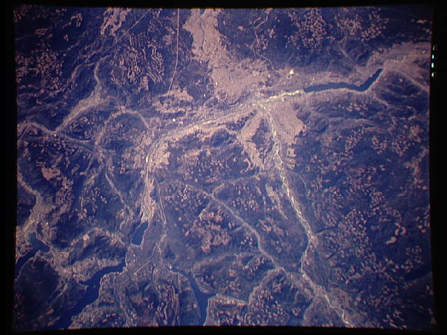
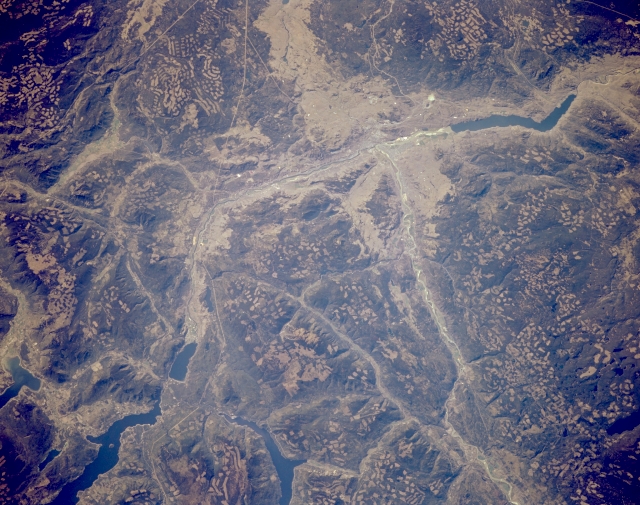
Image Caption: STS068-170-55B Kamloops Area, British Columbia, Canada October 1994
Kamloops, primarily an industrial city in south central British Columbia, is located along the northwest shore of the confluence of the North Thompson and South Thompson Rivers. It is difficult to locate the city because none of the urban infrastructure can be identified on this scale image. Kamloops Lake is the elongated reservoir (dark feature) just west of the city (upper right). As the pock-marked mountainous landscape shows, Kamloops is a major service center for the vast lumbering industry that is active in British Columbia. In addition to the clear cut areas on the mountain slopes, much of the valley in the vicinity of Kamloops shows evidence (lighter, tannish looking areas) of mining operations (mainly gold and copper). The thin, linear, light colored features are powerline right of ways and roads. Adams Lake and Shuswap Lake are the larger reservoirs in the lower left corner of the picture.
Kamloops, primarily an industrial city in south central British Columbia, is located along the northwest shore of the confluence of the North Thompson and South Thompson Rivers. It is difficult to locate the city because none of the urban infrastructure can be identified on this scale image. Kamloops Lake is the elongated reservoir (dark feature) just west of the city (upper right). As the pock-marked mountainous landscape shows, Kamloops is a major service center for the vast lumbering industry that is active in British Columbia. In addition to the clear cut areas on the mountain slopes, much of the valley in the vicinity of Kamloops shows evidence (lighter, tannish looking areas) of mining operations (mainly gold and copper). The thin, linear, light colored features are powerline right of ways and roads. Adams Lake and Shuswap Lake are the larger reservoirs in the lower left corner of the picture.
