STS068-161-106
| NASA Photo ID | STS068-161-106 |
| Focal Length | 250mm |
| Date taken | 1994.10.08 |
| Time taken | 07:36:01 GMT |

Cloud masks available for this image:
Spacecraft nadir point: 48.7° N, 42.2° E
Photo center point: 47.5° N, 39.5° E
Photo center point by machine learning:
Photo center point: 47.5° N, 39.5° E
Photo center point by machine learning:
Nadir to Photo Center: West
Spacecraft Altitude: 110 nautical miles (204km)
Country or Geographic Name: | RUSSIAN FEDERATION |
Features: | ROSTOV-NA-DONU AREA |
| Features Found Using Machine Learning: | |
Cloud Cover Percentage: | 0 (no clouds present) |
Sun Elevation Angle: | 33° |
Sun Azimuth: | 155° |
Camera: | Linhof |
Focal Length: | 250mm |
Camera Tilt: | High Oblique |
Format: | 5046: Kodak, natural color positive, Lumiere 100/5046, ASA 100, standard base |
Film Exposure: | Normal |
| Additional Information | |
| Width | Height | Annotated | Cropped | Purpose | Links |
|---|---|---|---|---|---|
| 5231 pixels | 4096 pixels | No | No | Earth From Space collection | Download Image |
| 639 pixels | 501 pixels | No | No | Earth From Space collection | Download Image |
| 640 pixels | 480 pixels | No | No | ISD 1 | Download Image |
Download Packaged File
Download a Google Earth KML for this Image
View photo footprint information
Download a GeoTIFF for this photo
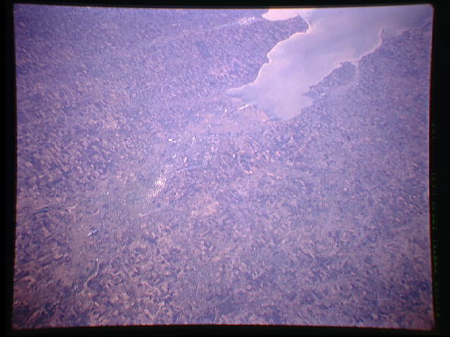
Image Caption: STS068-161-106 Don River, Russia October 1994
A large section of the intensively cultivated (angular field patterns) steppe country of southwest Russia is visible in this synoptic view. The industrial and cultural city of Rostov-On-Don with over a million inhabitants is located slightly above the center of the image. West of Rostov the Don River splits into several distributory channels that wind through the low-lying, swampy delta. Taganrogsky Bay, a northeast extension of the Sea of Azov, has sunlight reflecting off of the surface of the water, thereby creating a milky-colored feature (upper right). The extensive floodplain of the Don River extends diagonally from the corner of the image (bottom left) to the center of the image.
A large section of the intensively cultivated (angular field patterns) steppe country of southwest Russia is visible in this synoptic view. The industrial and cultural city of Rostov-On-Don with over a million inhabitants is located slightly above the center of the image. West of Rostov the Don River splits into several distributory channels that wind through the low-lying, swampy delta. Taganrogsky Bay, a northeast extension of the Sea of Azov, has sunlight reflecting off of the surface of the water, thereby creating a milky-colored feature (upper right). The extensive floodplain of the Don River extends diagonally from the corner of the image (bottom left) to the center of the image.
