STS066-90-83

| NASA Photo ID | STS066-90-83 |
| Focal Length | 100mm |
| Date taken | 1994.11.05 |
| Time taken | 18:54:55 GMT |
Resolutions offered for this image:
5700 x 5900 pixels 500 x 518 pixels 640 x 480 pixels 2574 x 2526 pixels 3354 x 3368 pixels
5700 x 5900 pixels 500 x 518 pixels 640 x 480 pixels 2574 x 2526 pixels 3354 x 3368 pixels

Cloud masks available for this image:
Spacecraft nadir point: 36.1° N, 112.2° W
Photo center point: 36.0° N, 112.0° W
Photo center point by machine learning:
Photo center point: 36.0° N, 112.0° W
Photo center point by machine learning:
Nadir to Photo Center: Southeast
Spacecraft Altitude: 163 nautical miles (302km)
Country or Geographic Name: | USA-ARIZONA |
Features: | GRAND CANYON |
| Features Found Using Machine Learning: | |
Cloud Cover Percentage: | 0 (no clouds present) |
Sun Elevation Angle: | 38° |
Sun Azimuth: | 175° |
Camera: | Hasselblad |
Focal Length: | 100mm |
Camera Tilt: | 5 degrees |
Format: | 5046: Kodak, natural color positive, Lumiere 100/5046, ASA 100, standard base |
Film Exposure: | Normal |
| Additional Information | |
| Width | Height | Annotated | Cropped | Purpose | Links |
|---|---|---|---|---|---|
| 5700 pixels | 5900 pixels | No | No | Download Image | |
| 500 pixels | 518 pixels | No | No | Download Image | |
| 640 pixels | 480 pixels | No | No | Download Image | |
| 2574 pixels | 2526 pixels | Earth From Space phase 2 | Download Image | ||
| 3354 pixels | 3368 pixels | Download Image |
Download Packaged File
Download a Google Earth KML for this Image
View photo footprint information
Download a GeoTIFF for this photo
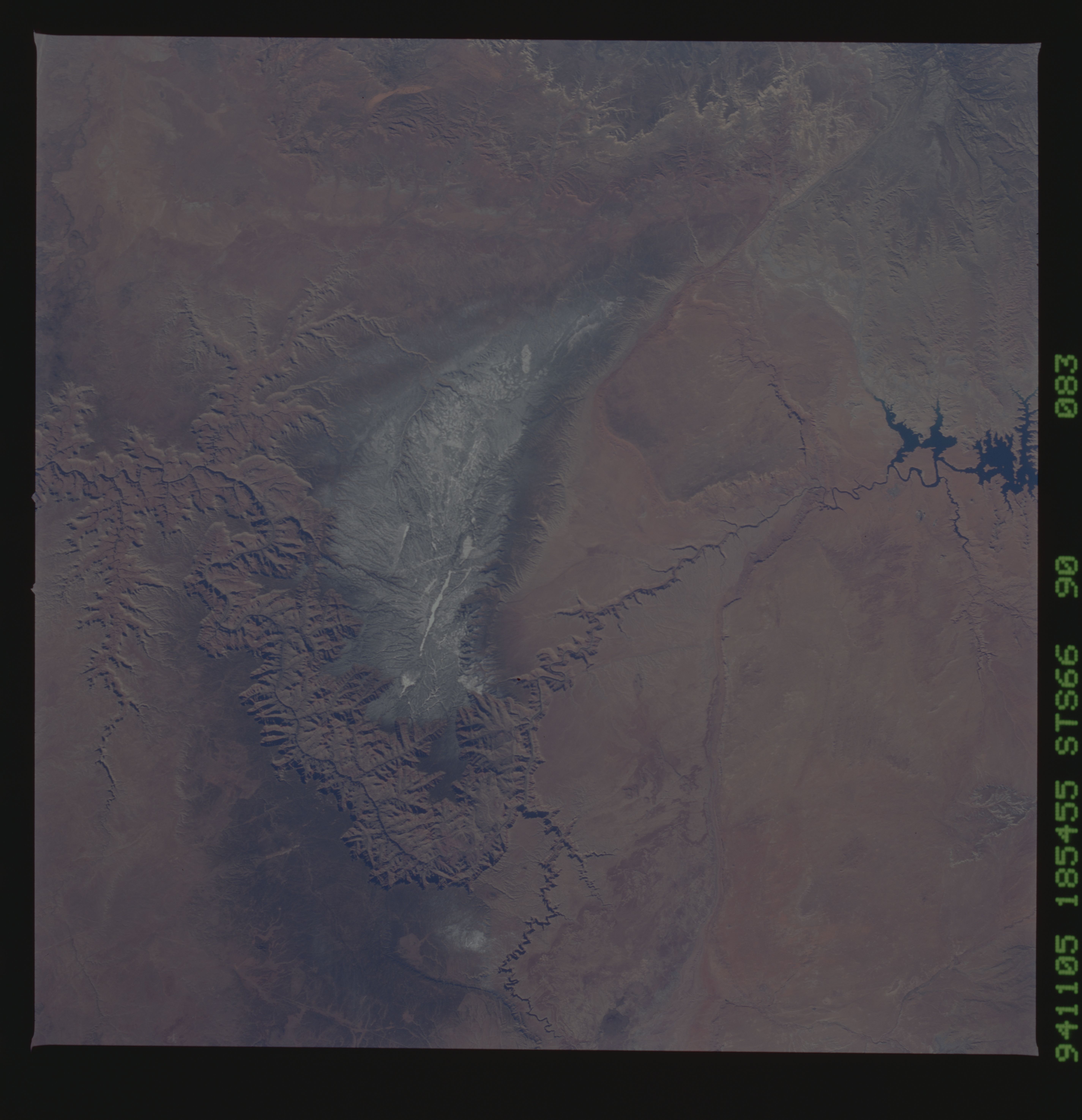
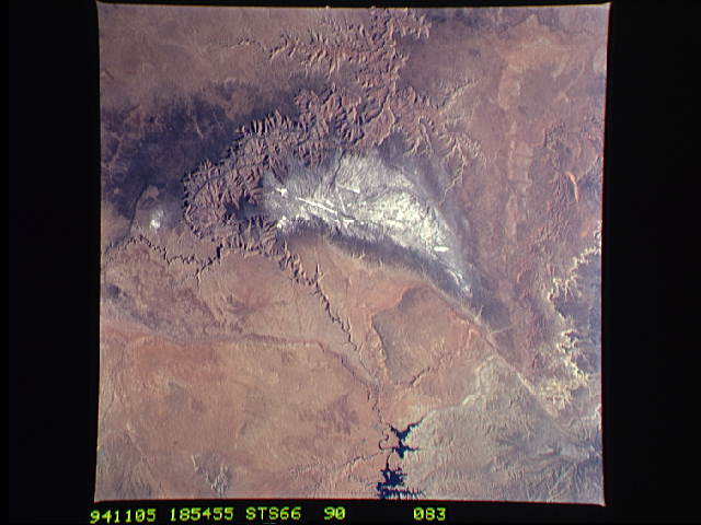
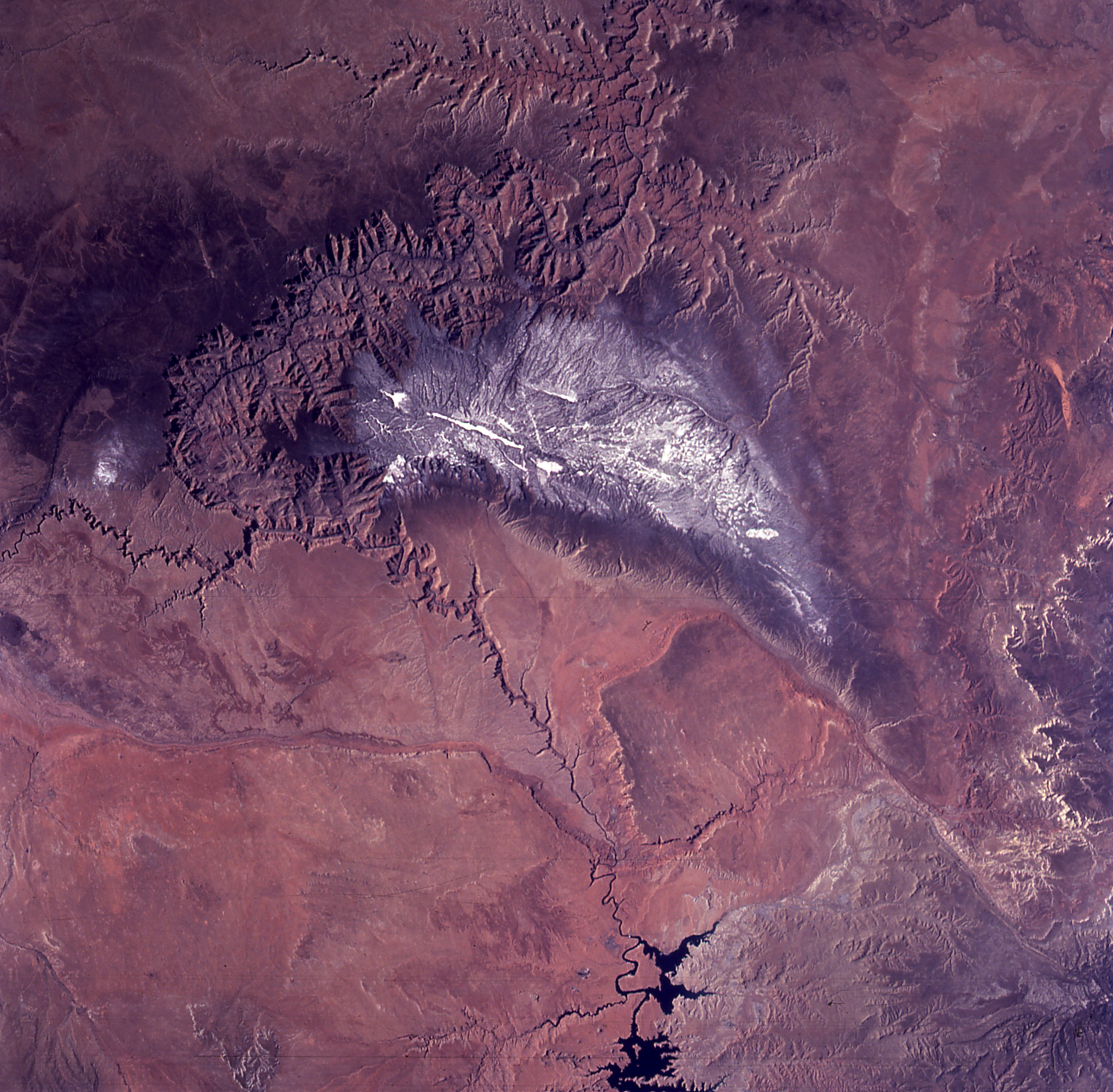
Image Caption: Snow covers the Kaibab Plateau on the northern side of the Colorado River in this view of the Grand Canyon (fig. 11). North is to the bottom of this view. The Colorado River has created a canyon which cuts through billions of years of geologic time. The Grand Canyon is 446 kilometers (277 miles) long, averages 16 kilometers (10 miles) wide, and is approximately 1.6 kilometers (1 mile) deep. The Coconino Plateau is located on the upper left side of the view, or to the south of the Colorado River. The direction of flow of the Colorado River is from the east to the west. Eventually the river turns south and empties into the Gulf of California. The southern portion of Lake Powell in Utah can be seen at the bottom center of the view.
Snow covers the Kaibab Plateau on the northern side of the Colorado River in this November, 1994 view of the Grand Canyon. North is to the bottom of this view. The Colorado River has created a canyon which cuts through billions of years of geologic time. The Grand Canyon is 446 kilometers (277 miles) long, averages 16 kilometers (10 miles) wide, and is approximately 1.6 kilometers (1 mile) deep. The Coconino Plateau is located on the upper left side of the view, or to the south of the Colorado River. The direction of the flow of the Colorado River is from the east to the west. Eventually the river turns south and empties into the Gulf of California. The southern portion of Lake Powell in Utah can be seen at the bottom center of the view.
Snow covers the Kaibab Plateau on the northern side of the Colorado River in this November, 1994 view of the Grand Canyon. North is to the bottom of this view. The Colorado River has created a canyon which cuts through billions of years of geologic time. The Grand Canyon is 446 kilometers (277 miles) long, averages 16 kilometers (10 miles) wide, and is approximately 1.6 kilometers (1 mile) deep. The Coconino Plateau is located on the upper left side of the view, or to the south of the Colorado River. The direction of the flow of the Colorado River is from the east to the west. Eventually the river turns south and empties into the Gulf of California. The southern portion of Lake Powell in Utah can be seen at the bottom center of the view.
