STS066-80-11
| NASA Photo ID | STS066-80-11 |
| Focal Length | 250mm |
| Date taken | 1994.11.10 |
| Time taken | 23:52:34 GMT |
Resolutions offered for this image:
4096 x 4096 pixels 640 x 640 pixels 5700 x 5900 pixels 500 x 518 pixels 640 x 480 pixels 525 x 515 pixels
4096 x 4096 pixels 640 x 640 pixels 5700 x 5900 pixels 500 x 518 pixels 640 x 480 pixels 525 x 515 pixels


Cloud masks available for this image:
Spacecraft nadir point: 5.2° N, 119.5° E
Photo center point: 5.0° N, 119.0° E
Photo center point by machine learning:
Photo center point: 5.0° N, 119.0° E
Photo center point by machine learning:
Nadir to Photo Center: West
Spacecraft Altitude: 158 nautical miles (293km)
Country or Geographic Name: | MALAYSIA |
Features: | PENINSULA, FIELD PATTERNS |
| Features Found Using Machine Learning: | |
Cloud Cover Percentage: | 0 (no clouds present) |
Sun Elevation Angle: | 28° |
Sun Azimuth: | 113° |
Camera: | Hasselblad |
Focal Length: | 250mm |
Camera Tilt: | 12 degrees |
Format: | 2443: Kodak Aerochrome 2443, color IR, thin base, EA-5 process thru June 1999, E-6 process afterward |
Film Exposure: | Normal |
| Additional Information | |
| Width | Height | Annotated | Cropped | Purpose | Links |
|---|---|---|---|---|---|
| 4096 pixels | 4096 pixels | No | No | Earth From Space collection | Download Image |
| 640 pixels | 640 pixels | No | No | Earth From Space collection | Download Image |
| 5700 pixels | 5900 pixels | No | No | Download Image | |
| 500 pixels | 518 pixels | No | No | Download Image | |
| 640 pixels | 480 pixels | No | No | Download Image | |
| 525 pixels | 515 pixels | Download Image |
Download Packaged File
Download a Google Earth KML for this Image
View photo footprint information
Download a GeoTIFF for this photo
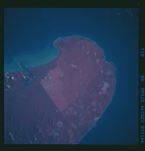
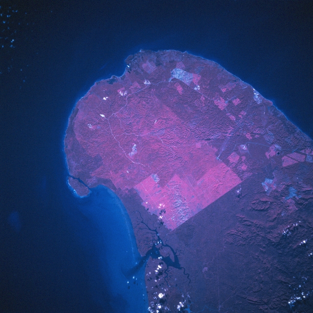
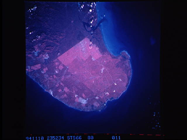
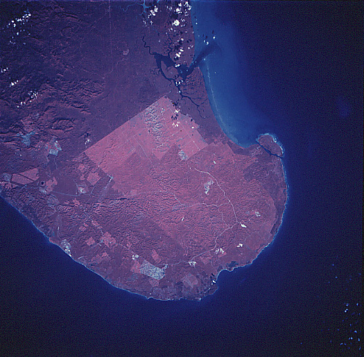
Image Caption: STS066-080-011 Sabah, Malaysia November 1994
The color infrared image (green vegetation is portrayed as shades of red) dramatically shows where development has and is occurring on this northeast peninsula of Sabah, the second largest state of Malaysia (located on the island of Borneo). The Sulu (northeast) and Celebes (east) Seas separate this peninsula from several of the Philippine islands that are located east of Borneo. The darker terrain (deeper reds bottom half of image) shows a mixture of relatively flat, swampy, densely vegetated landscape along the north coast of the peninsula; while low, rainforest - covered mountains are visible near the lower right corner of the image. The lighter shades of red indicate where agricultural plantations have replaced the rainforests. The widely scattered, grayish-looking areas show where the land has been recently cleared, either for agricultural purposes or mining activities.
The color infrared image (green vegetation is portrayed as shades of red) dramatically shows where development has and is occurring on this northeast peninsula of Sabah, the second largest state of Malaysia (located on the island of Borneo). The Sulu (northeast) and Celebes (east) Seas separate this peninsula from several of the Philippine islands that are located east of Borneo. The darker terrain (deeper reds bottom half of image) shows a mixture of relatively flat, swampy, densely vegetated landscape along the north coast of the peninsula; while low, rainforest - covered mountains are visible near the lower right corner of the image. The lighter shades of red indicate where agricultural plantations have replaced the rainforests. The widely scattered, grayish-looking areas show where the land has been recently cleared, either for agricultural purposes or mining activities.
