STS066-152-170
| NASA Photo ID | STS066-152-170 |
| Focal Length | 90mm |
| Date taken | 1994.11.06 |
| Time taken | 23:16:01 GMT |

Cloud masks available for this image:
Spacecraft nadir point: 24.4° S, 130.8° E
Photo center point: 25.0° S, 131.0° E
Photo center point by machine learning:
Photo center point: 25.0° S, 131.0° E
Photo center point by machine learning:
Nadir to Photo Center: South
Spacecraft Altitude: 160 nautical miles (296km)
Country or Geographic Name: | AUSTRALIA-NT |
Features: | LAKE AMADEUS |
| Features Found Using Machine Learning: | |
Cloud Cover Percentage: | 0 (no clouds present) |
Sun Elevation Angle: | 37° |
Sun Azimuth: | 92° |
Camera: | Linhof |
Focal Length: | 90mm |
Camera Tilt: | 13 degrees |
Format: | 5046: Kodak, natural color positive, Lumiere 100/5046, ASA 100, standard base |
Film Exposure: | Normal |
| Additional Information | |
| Width | Height | Annotated | Cropped | Purpose | Links |
|---|---|---|---|---|---|
| 5120 pixels | 4000 pixels | No | No | Earth From Space collection | Download Image |
| 640 pixels | 500 pixels | No | No | Earth From Space collection | Download Image |
| 640 pixels | 480 pixels | No | No | ISD 1 | Download Image |
Download Packaged File
Download a Google Earth KML for this Image
View photo footprint information
Download a GeoTIFF for this photo
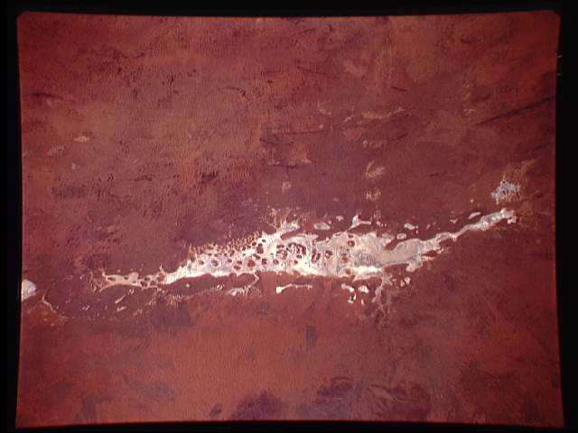
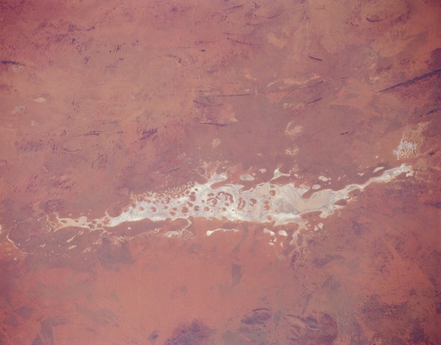
Image Caption: STS066-152-170 Lake Amadeus, Northern Territory, Australia November 1994
Located in the southwest corner of Northern Territory and near the geographic center of Australia, Lake Amadeus is one of hundreds of ephemeral lakes (called playas) that characterize the desert landscape of central and especially western Australia. When there has been sufficient rainfall, this lake is part of an east-flowing drainage system that eventually connects to the Finke River. Like other ephemeral lakes in central Australia, water quality is "fresh" immediately after it rains but rapidly becomes brackish in a short period of time. Lake Amadeus is a major water discharge area for central Australia, and ground water seeps to the surface around the periphery of the lake. The darker features within the flat plains of the playa (whitish area) are slightly elevated, vegetated islands. Most of the surrounding terrain is covered by sand dunes, sand ridges, and desert vegetation. The length of the lake is approximately 75 miles (120 kilometers).
Located in the southwest corner of Northern Territory and near the geographic center of Australia, Lake Amadeus is one of hundreds of ephemeral lakes (called playas) that characterize the desert landscape of central and especially western Australia. When there has been sufficient rainfall, this lake is part of an east-flowing drainage system that eventually connects to the Finke River. Like other ephemeral lakes in central Australia, water quality is "fresh" immediately after it rains but rapidly becomes brackish in a short period of time. Lake Amadeus is a major water discharge area for central Australia, and ground water seeps to the surface around the periphery of the lake. The darker features within the flat plains of the playa (whitish area) are slightly elevated, vegetated islands. Most of the surrounding terrain is covered by sand dunes, sand ridges, and desert vegetation. The length of the lake is approximately 75 miles (120 kilometers).
