STS062-101-33
| NASA Photo ID | STS062-101-33 |
| Focal Length | 250mm |
| Date taken | 1994.03.14 |
| Time taken | 06:46:38 GMT |
Resolutions offered for this image:
3968 x 3904 pixels 639 x 629 pixels 5700 x 5900 pixels 500 x 518 pixels 640 x 480 pixels
3968 x 3904 pixels 639 x 629 pixels 5700 x 5900 pixels 500 x 518 pixels 640 x 480 pixels


Cloud masks available for this image:
Spacecraft nadir point: 32.2° S, 142.3° E
Photo center point: 30.5° S, 139.0° E
Photo center point by machine learning:
Photo center point: 30.5° S, 139.0° E
Photo center point by machine learning:
Nadir to Photo Center: Northwest
Spacecraft Altitude: 163 nautical miles (302km)
Country or Geographic Name: | AUSTRALIA-SA |
Features: | L. TORRENS, MT. RANGE |
| Features Found Using Machine Learning: | |
Cloud Cover Percentage: | 0 (no clouds present) |
Sun Elevation Angle: | 25° |
Sun Azimuth: | 284° |
Camera: | Hasselblad |
Focal Length: | 250mm |
Camera Tilt: | 54 degrees |
Format: | 5048: Kodak, natural color positive, Lumiere 100x/5048, ASA 100x, standard base |
Film Exposure: | Normal |
| Additional Information | |
| Width | Height | Annotated | Cropped | Purpose | Links |
|---|---|---|---|---|---|
| 3968 pixels | 3904 pixels | No | No | Earth From Space collection | Download Image |
| 639 pixels | 629 pixels | No | No | Earth From Space collection | Download Image |
| 5700 pixels | 5900 pixels | No | No | Download Image | |
| 500 pixels | 518 pixels | No | No | Download Image | |
| 640 pixels | 480 pixels | No | No | Download Image |
Download Packaged File
Download a Google Earth KML for this Image
View photo footprint information
Download a GeoTIFF for this photo
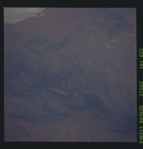
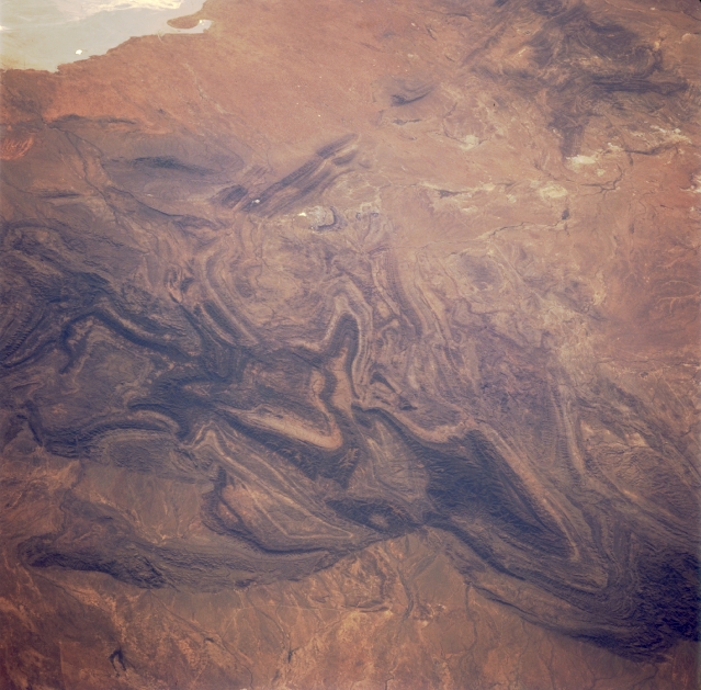
Image Caption: STS062-101-033 Flinders Range, South Australia, Australia March 1994
The northern end of the Flinders Ranges in South Australia show up in dramatic fashion (darker and more textured-looking features), highlighting the oldest and most rugged mountains in Australia. This chain of mountains is mostly made up of sedimentary rock with steep ridges and deep gorges. Several elevations in this section of the Flinders Ranges exceed 3000 feet (915 meters) above sea level. The landscape has a rich heritage of mining activities that have included copper, silver, gold, and coal. These ranges have also provided a favorable environment for farmers, pastoralists (sheep), and the Aboriginal peoples. The small "white" spot (slightly above and left of center) is where Leigh Creek, an oasis in an otherwise arid setting, is located. This town is known for the mining of a brown coal. A small section of the northeast shoreline of dry lake, Lake Torrens (light colored feature), is visible in the upper left corner of the picture. A barely discernible string of dry lakes can be traced to the north from the Leigh Creek area.
The northern end of the Flinders Ranges in South Australia show up in dramatic fashion (darker and more textured-looking features), highlighting the oldest and most rugged mountains in Australia. This chain of mountains is mostly made up of sedimentary rock with steep ridges and deep gorges. Several elevations in this section of the Flinders Ranges exceed 3000 feet (915 meters) above sea level. The landscape has a rich heritage of mining activities that have included copper, silver, gold, and coal. These ranges have also provided a favorable environment for farmers, pastoralists (sheep), and the Aboriginal peoples. The small "white" spot (slightly above and left of center) is where Leigh Creek, an oasis in an otherwise arid setting, is located. This town is known for the mining of a brown coal. A small section of the northeast shoreline of dry lake, Lake Torrens (light colored feature), is visible in the upper left corner of the picture. A barely discernible string of dry lakes can be traced to the north from the Leigh Creek area.
