STS060-101-53
| NASA Photo ID | STS060-101-53 |
| Focal Length | 250mm |
| Date taken | 1994.02.05 |
| Time taken | 22:42:50 GMT |
Resolutions offered for this image:
4048 x 4048 pixels 639 x 639 pixels 5700 x 5900 pixels 500 x 518 pixels 640 x 480 pixels
4048 x 4048 pixels 639 x 639 pixels 5700 x 5900 pixels 500 x 518 pixels 640 x 480 pixels


Cloud masks available for this image:
Spacecraft nadir point: 26.0° N, 109.7° W
Photo center point: 25.5° N, 108.5° W
Photo center point by machine learning:
Photo center point: 25.5° N, 108.5° W
Photo center point by machine learning:
Nadir to Photo Center: East
Spacecraft Altitude: 190 nautical miles (352km)
Country or Geographic Name: | MEXICO |
Features: | OHVIRA BAY, AGRICULTURE |
| Features Found Using Machine Learning: | |
Cloud Cover Percentage: | 0 (no clouds present) |
Sun Elevation Angle: | 28° |
Sun Azimuth: | 233° |
Camera: | Hasselblad |
Focal Length: | 250mm |
Camera Tilt: | 22 degrees |
Format: | 2443: Kodak Aerochrome 2443, color IR, thin base, EA-5 process thru June 1999, E-6 process afterward |
Film Exposure: | Normal |
| Additional Information | |
| Width | Height | Annotated | Cropped | Purpose | Links |
|---|---|---|---|---|---|
| 4048 pixels | 4048 pixels | No | No | Earth From Space collection | Download Image |
| 639 pixels | 639 pixels | No | No | Earth From Space collection | Download Image |
| 5700 pixels | 5900 pixels | No | No | Download Image | |
| 500 pixels | 518 pixels | No | No | Download Image | |
| 640 pixels | 480 pixels | No | No | Download Image |
Download Packaged File
Download a Google Earth KML for this Image
View photo footprint information
Download a GeoTIFF for this photo
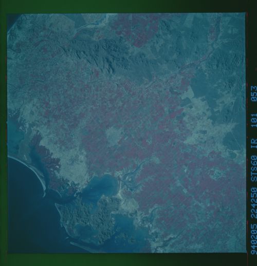
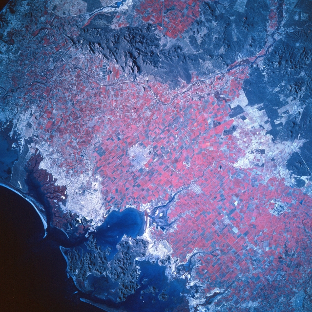
Image Caption: STS060-101-053 La Mochis Area, Mexico February 1994
The color infrared image helps to identify the extensive land area that is being used for commercial agriculture along this coastal section of northwest Mexico. Notice the sizeable, angular field patterns (red colors map the extent of healthy green plants) that are widespread across the dry coastal plain of Sinaloa State. La Mochis, visible near the center of the image, has been a boomtown since the 1950's when the rapid growth of irrigated agriculture started to take in this semiarid region of northern Mexico. Wheat, cotton, soybean, oilseeds, and winter vegetables, especially tomatoes are among the main crops grown. Low mountains (darker, more textured-looking landscape) can be discriminated along the coast (bottom center) and north of the Fuerte River (top center). The dark-looking, uniform feature south of La Mochis is Ohvira Bay, one of many bays that indent this section of coastline in northwest Mexico. The lighter colored landscape inland from the coast shows poorly drained topography that contains virtually no permanent vegetative cover.
The color infrared image helps to identify the extensive land area that is being used for commercial agriculture along this coastal section of northwest Mexico. Notice the sizeable, angular field patterns (red colors map the extent of healthy green plants) that are widespread across the dry coastal plain of Sinaloa State. La Mochis, visible near the center of the image, has been a boomtown since the 1950's when the rapid growth of irrigated agriculture started to take in this semiarid region of northern Mexico. Wheat, cotton, soybean, oilseeds, and winter vegetables, especially tomatoes are among the main crops grown. Low mountains (darker, more textured-looking landscape) can be discriminated along the coast (bottom center) and north of the Fuerte River (top center). The dark-looking, uniform feature south of La Mochis is Ohvira Bay, one of many bays that indent this section of coastline in northwest Mexico. The lighter colored landscape inland from the coast shows poorly drained topography that contains virtually no permanent vegetative cover.
