STS059-L08-96
| NASA Photo ID | STS059-L08-96 |
| Focal Length | 90mm |
| Date taken | 1994.04.11 |
| Time taken | 18:16:52 GMT |

Cloud masks available for this image:
Spacecraft nadir point: 50.8° N, 93.6° W
Photo center point: 48.0° N, 95.0° W
Photo center point by machine learning:
Photo center point: 48.0° N, 95.0° W
Photo center point by machine learning:
Nadir to Photo Center: South
Spacecraft Altitude: 118 nautical miles (219km)
Country or Geographic Name: | USA-MINNESOTA |
Features: | UPPER & LOWER RED L, AGR |
| Features Found Using Machine Learning: | |
Cloud Cover Percentage: | 0 (no clouds present) |
Sun Elevation Angle: | 48° |
Sun Azimuth: | 181° |
Camera: | Linhof |
Focal Length: | 90mm |
Camera Tilt: | Low Oblique |
Format: | 5048: Kodak, natural color positive, Lumiere 100x/5048, ASA 100x, standard base |
Film Exposure: | Normal |
| Additional Information | |
| Width | Height | Annotated | Cropped | Purpose | Links |
|---|---|---|---|---|---|
| 5056 pixels | 3968 pixels | No | No | Earth From Space collection | Download Image |
| 640 pixels | 502 pixels | No | No | Earth From Space collection | Download Image |
| 640 pixels | 480 pixels | No | No | ISD 1 | Download Image |
Download Packaged File
Download a Google Earth KML for this Image
View photo footprint information
Download a GeoTIFF for this photo
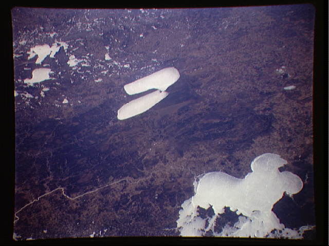
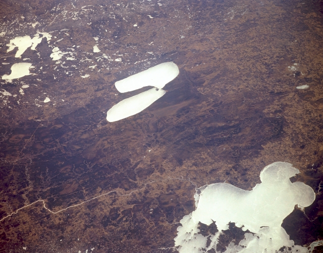
Image Caption: STS059-L08-096 Lake of the Woods and Red Lake, Minnesota, U.S.A. April 1994
This south-southwest-looking, low-oblique photograph features ice- and snow-covered Lake of the Woods (bottom right) and Red Lake (center) in northern Minnesota. A remnant of glacial Lake Agassiz, Lake of the Woods is 72 miles (116 kilometers) long, 10 to 60 miles (16 to 97 kilometers) wide, and covers 1695 square miles (4390 square kilometers). The lake, with its irregular shoreline and approximately 14 000 islands, receives the Rainy River (lower left) on its southern end and is drained to the north by the Winnipeg River (not visible). Red Lake, whose western and southern portions are part of Red Lake Indian Reservation, is divided into upper and lower sections, is 41 miles (66 kilometers) long, and covers 451 square miles (1168 square kilometers). With abundant fish and game, Lake of the Woods and Red Lake are resort areas, with Beltrami Island State Forest located between them. Apparent are numerous ice-covered lakes, including irregular Leech Lake in Chippewa National Forest, demonstrating why Minnesota is known as the Land of 10 000 Lakes.
This south-southwest-looking, low-oblique photograph features ice- and snow-covered Lake of the Woods (bottom right) and Red Lake (center) in northern Minnesota. A remnant of glacial Lake Agassiz, Lake of the Woods is 72 miles (116 kilometers) long, 10 to 60 miles (16 to 97 kilometers) wide, and covers 1695 square miles (4390 square kilometers). The lake, with its irregular shoreline and approximately 14 000 islands, receives the Rainy River (lower left) on its southern end and is drained to the north by the Winnipeg River (not visible). Red Lake, whose western and southern portions are part of Red Lake Indian Reservation, is divided into upper and lower sections, is 41 miles (66 kilometers) long, and covers 451 square miles (1168 square kilometers). With abundant fish and game, Lake of the Woods and Red Lake are resort areas, with Beltrami Island State Forest located between them. Apparent are numerous ice-covered lakes, including irregular Leech Lake in Chippewa National Forest, demonstrating why Minnesota is known as the Land of 10 000 Lakes.
