STS056-92-28
| NASA Photo ID | STS056-92-28 |
| Focal Length | 250mm |
| Date taken | 1993.04.11 |
| Time taken | 06:23:07 GMT |

Cloud masks available for this image:
Spacecraft nadir point: 20.7° N, 35.4° E
Photo center point: 21.0° N, 37.0° E
Photo center point by machine learning:
Photo center point: 21.0° N, 37.0° E
Photo center point by machine learning:
Nadir to Photo Center: East
Spacecraft Altitude: 161 nautical miles (298km)
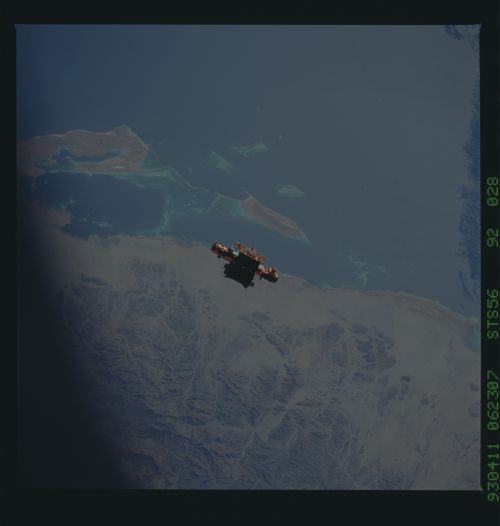
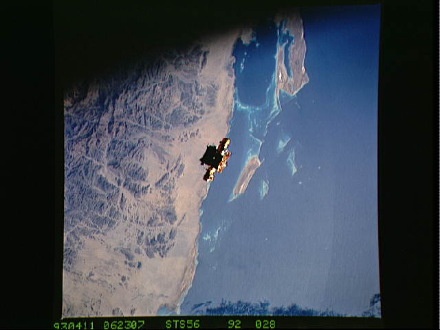
Country or Geographic Name: | SUDAN |
Features: | MUKAWWAR I., SATELLITE |
| Features Found Using Machine Learning: | |
Cloud Cover Percentage: | 0 (no clouds present) |
Sun Elevation Angle: | 41° |
Sun Azimuth: | 97° |
Camera: | Hasselblad |
Focal Length: | 250mm |
Camera Tilt: | 31 degrees |
Format: | 5017: Kodak, natural color positive, Ektachrome, X Professional, ASA 64, standard base |
Film Exposure: | Normal |
| Additional Information | |
| Width | Height | Annotated | Cropped | Purpose | Links |
|---|---|---|---|---|---|
| 5700 pixels | 6000 pixels | No | No | Download Image | |
| 500 pixels | 526 pixels | No | No | Download Image | |
| 640 pixels | 480 pixels | No | No | Download Image |
Download Packaged File
Download a Google Earth KML for this Image
View photo footprint information
Download a GeoTIFF for this photo
Image Caption: During STS-56, the Shuttle Pointed Autonomous Research Tool for Astronomy 201 (SPARTAN-201), a freeflying payload, was captured on 70mm film as it drifts over the Red Sea coast of Sudan. SPARTAN-201 was photographed by the crewmembers aboard Discovery, Orbiter Vehicle (OV) 103. On the mission's third day, crewmembers used the remote manipulator system (RMS) to lift the satellite from its support structure in OV-103's payload bay (PLB) and release it into space. SPARTAN-201 was later recaptured by OV-103's RMS and returned to Earth with the astronaut crew. The cape structure in the background is Ras abu Shagara, north of Port Sudan.
