STS056-78-83
| NASA Photo ID | STS056-78-83 |
| Focal Length | 250mm |
| Date taken | 1993.04.10 |
| Time taken | 06:19:48 GMT |


Cloud masks available for this image:
Spacecraft nadir point: 10.2° N, 49.3° E
Photo center point: 10.0° N, 51.0° E
Photo center point by machine learning:
Photo center point: 10.0° N, 51.0° E
Photo center point by machine learning:
Nadir to Photo Center: East
Spacecraft Altitude: 160 nautical miles (296km)
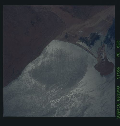
Country or Geographic Name: | SOMALIA |
Features: | SOUTH HAFUN BAY, SUNGLINT |
| Features Found Using Machine Learning: | |
Cloud Cover Percentage: | 5 (1-10)% |
Sun Elevation Angle: | 54° |
Sun Azimuth: | 90° |
Camera: | Hasselblad |
Focal Length: | 250mm |
Camera Tilt: | 33 degrees |
Format: | 5017: Kodak, natural color positive, Ektachrome, X Professional, ASA 64, standard base |
Film Exposure: | Normal |
| Additional Information | |
| Width | Height | Annotated | Cropped | Purpose | Links |
|---|---|---|---|---|---|
| 5700 pixels | 6000 pixels | No | No | Download Image | |
| 500 pixels | 526 pixels | No | No | Download Image | |
| 640 pixels | 480 pixels | No | No | Download Image |
Download Packaged File
Download a Google Earth KML for this Image
View photo footprint information
Download a GeoTIFF for this photo
Image Caption: STS-56 Earth observation taken aboard Discovery, Orbiter Vehicle (OV) 103, is of a sun-glinted ocean along the northeastern coast of Somalia. The small island of Xaafuun is connected to the mainland by a well-developed double tombolo-two sand bars. Between the two toombolos a lagoon is formed which gradually fills with sediment and becomes a flat sand bar. Better known double tombolos include those of Gibraltar, the now-partially submerged giant tombolos forming Adam's Bridge (Palk Strait) connecting Sri Lanka to India, Monte Argentario in Italy, and Long Island, New York. Such tombolos usually indicate a constant sediment source and a strong unidirectional or bi-directional (monsoonal) long shore current. In this case, sediment is provided by the plumes of the major African rivers debauching into the Mozambique Channel. The sediment is carried predominately to the northeast along the coast by the swiftly moving monsoonal Agulhas Current. Visible in this scene are internal waves, shear
