STS056-153-53
| NASA Photo ID | STS056-153-53 |
| Focal Length | 90mm |
| Date taken | 1993.04.__ |
| Time taken | GMT |

Cloud masks available for this image:
Spacecraft nadir point:
Photo center point: 14.5° S, 125.0° E
Photo center point by machine learning:
Photo center point: 14.5° S, 125.0° E
Photo center point by machine learning:
Nadir to Photo Center:
Spacecraft Altitude: nautical miles (0km)
Country or Geographic Name: | AUSTRALIA-WA |
Features: | COAST, BONAPARTE ISLANDS |
| Features Found Using Machine Learning: | |
Cloud Cover Percentage: | 0 (no clouds present) |
Sun Elevation Angle: | ° |
Sun Azimuth: | ° |
Camera: | Linhof |
Focal Length: | 90mm |
Camera Tilt: | Low Oblique |
Format: | QX868: Kodak, natural color positive, Ektachrome QX868(5017 emulsion), ASA 64, thin base |
Film Exposure: | Normal |
| Additional Information | |
| Width | Height | Annotated | Cropped | Purpose | Links |
|---|---|---|---|---|---|
| 3968 pixels | 5088 pixels | No | No | Earth From Space collection | Download Image |
| 499 pixels | 640 pixels | No | No | Earth From Space collection | Download Image |
| 640 pixels | 480 pixels | No | No | ISD 1 | Download Image |
Download Packaged File
Download a Google Earth KML for this Image
View photo footprint information
Download a GeoTIFF for this photo
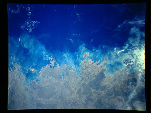
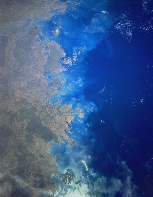
Image Caption: STS056-153-053 Bonaparte Archipelago, Western Australia, Australia April 1993
The Bonaparte Archipelago stretches along the north coast of the Kimberley Plateau in Western Australia. This particular image extends from Vansittart Bay (small area of sunglint at bottom center) to Collier Bay (upper middle). The shallow coastal waters of the continental shelf are light blue in color and include reefs and shoals. The deeper waters of the Indian Ocean are dark blue in color. The colors of the land reflect differences in elevation and the associated vegetation. The darkest terrain is more elevated, usually more than 1000 feet (305 meters) above sea level.
The Bonaparte Archipelago stretches along the north coast of the Kimberley Plateau in Western Australia. This particular image extends from Vansittart Bay (small area of sunglint at bottom center) to Collier Bay (upper middle). The shallow coastal waters of the continental shelf are light blue in color and include reefs and shoals. The deeper waters of the Indian Ocean are dark blue in color. The colors of the land reflect differences in elevation and the associated vegetation. The darkest terrain is more elevated, usually more than 1000 feet (305 meters) above sea level.
