STS056-153-182
| NASA Photo ID | STS056-153-182 |
| Focal Length | 90mm |
| Date taken | 1993.04.12 |
| Time taken | 07:56:01 GMT |

Cloud masks available for this image:
Spacecraft nadir point: 34.8° N, 6.2° W
Photo center point: 33.0° N, 7.0° W
Photo center point by machine learning:
Photo center point: 33.0° N, 7.0° W
Photo center point by machine learning:
Nadir to Photo Center: South
Spacecraft Altitude: 160 nautical miles (296km)
Country or Geographic Name: | MOROCCO |
Features: | COAST, CASABLANCA, INTERIOR |
| Features Found Using Machine Learning: | |
Cloud Cover Percentage: | 40 (26-50)% |
Sun Elevation Angle: | 23° |
Sun Azimuth: | 96° |
Camera: | Linhof |
Focal Length: | 90mm |
Camera Tilt: | 36 degrees |
Format: | QX868: Kodak, natural color positive, Ektachrome QX868(5017 emulsion), ASA 64, thin base |
Film Exposure: | Normal |
| Additional Information | |
| Width | Height | Annotated | Cropped | Purpose | Links |
|---|---|---|---|---|---|
| 5161 pixels | 4038 pixels | No | No | Earth From Space collection | Download Image |
| 639 pixels | 500 pixels | No | No | Earth From Space collection | Download Image |
| 640 pixels | 480 pixels | No | No | ISD 1 | Download Image |
Download Packaged File
Download a Google Earth KML for this Image
View photo footprint information
Download a GeoTIFF for this photo
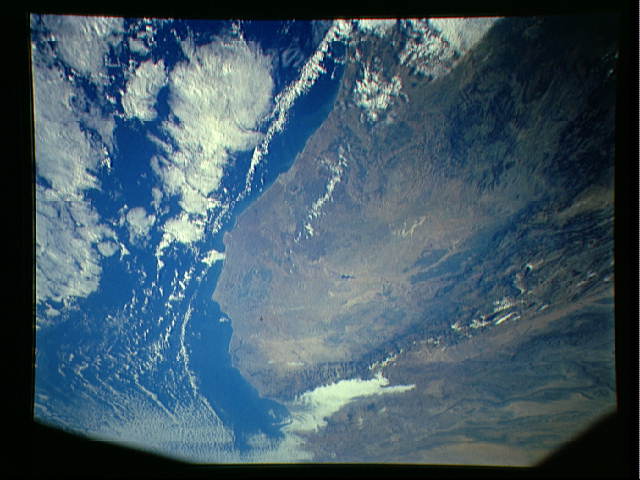
Image Caption: STS056-153-182 Coastal Plains, Morocco April 1993
Although one-third of Morocco is mountainous, this photograph shows the country's west-central coastal plains. Casablanca, the largest city, chief port, and major manufacturing center of the country, is visible along the coast near the center of the photograph. The topography east of Casablanca is dissected plateau and hilly terrain. Annual rainfall seldom exceeds 12 inches (30 centimeters) for any part of this region, although rainfall amounts increase slightly from the west coast toward the Atlas Mountains. These mountains extend across the entire southeastern frontier of Morocco and form a major physical barrier for ground transportation. Several dark green areas show the larger concentrations of agricultural activities. A small section of the northeast-southwest trending Atlas Mountains can be seen as a well-defined line of snow-capped mountains (southeast quadrant of the photograph), with remaining snow found only in elevations exceeding 9000 feet (2700 meters). Several peaks within the Atlas range exceed 12 000 feet (3600 meters) above sea level.
Although one-third of Morocco is mountainous, this photograph shows the country's west-central coastal plains. Casablanca, the largest city, chief port, and major manufacturing center of the country, is visible along the coast near the center of the photograph. The topography east of Casablanca is dissected plateau and hilly terrain. Annual rainfall seldom exceeds 12 inches (30 centimeters) for any part of this region, although rainfall amounts increase slightly from the west coast toward the Atlas Mountains. These mountains extend across the entire southeastern frontier of Morocco and form a major physical barrier for ground transportation. Several dark green areas show the larger concentrations of agricultural activities. A small section of the northeast-southwest trending Atlas Mountains can be seen as a well-defined line of snow-capped mountains (southeast quadrant of the photograph), with remaining snow found only in elevations exceeding 9000 feet (2700 meters). Several peaks within the Atlas range exceed 12 000 feet (3600 meters) above sea level.
