STS056-152-249
| NASA Photo ID | STS056-152-249 |
| Focal Length | 90mm |
| Date taken | 1993.04.10 |
| Time taken | 15:32:03 GMT |
Cloud masks available for this image:
Spacecraft nadir point: 22.6° S, 68.5° W
Photo center point: 22.5° S, 69.0° W
Photo center point by machine learning:
Photo center point: 22.5° S, 69.0° W
Photo center point by machine learning:
Nadir to Photo Center: West
Spacecraft Altitude: 162 nautical miles (300km)
Country or Geographic Name: | CHILE |
Features: | ATACAMA DES, ALTIPLANO |
| Features Found Using Machine Learning: | |
Cloud Cover Percentage: | 20 (11-25)% |
Sun Elevation Angle: | 56° |
Sun Azimuth: | 29° |
Camera: | Linhof |
Focal Length: | 90mm |
Camera Tilt: | 11 degrees |
Format: | QX868: Kodak, natural color positive, Ektachrome QX868(5017 emulsion), ASA 64, thin base |
Film Exposure: | Normal |
| Additional Information | |
| Width | Height | Annotated | Cropped | Purpose | Links |
|---|---|---|---|---|---|
| 4037 pixels | 5166 pixels | No | No | Earth From Space collection | Download Image |
| 500 pixels | 639 pixels | No | No | Earth From Space collection | Download Image |
| 640 pixels | 480 pixels | No | No | ISD 1 | Download Image |
Download Packaged File
Download a Google Earth KML for this Image
View photo footprint information
Download a GeoTIFF for this photo
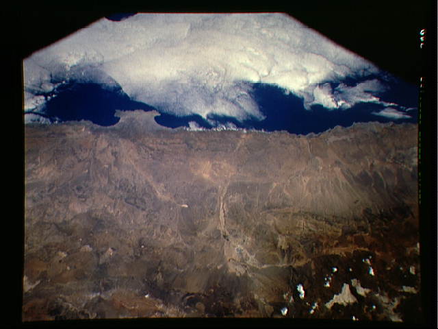
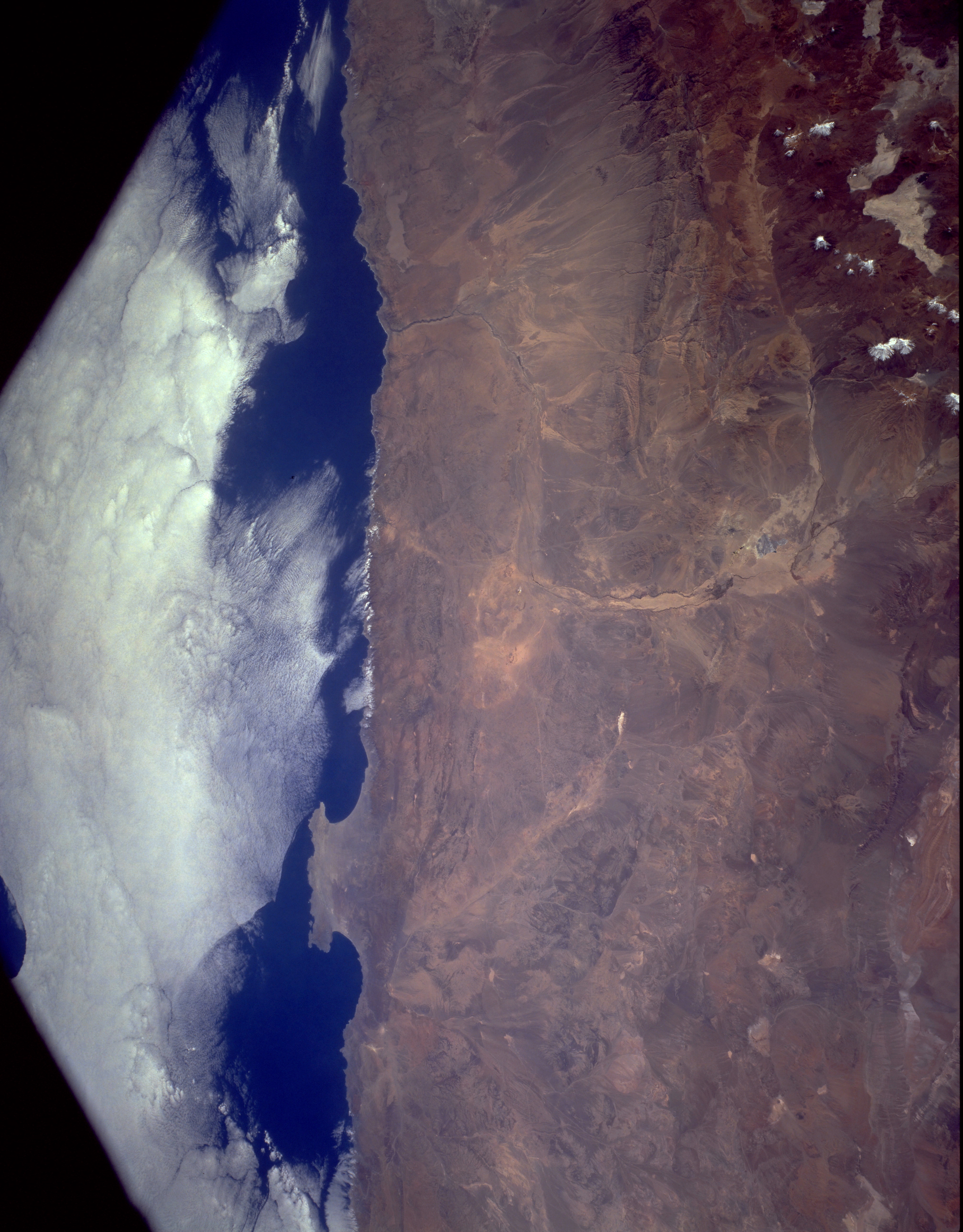
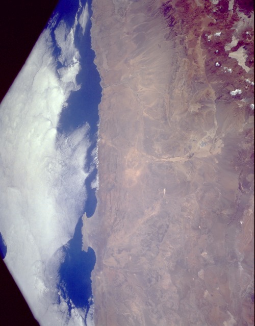
Image Caption: STS056-152-249 Atacama Desert, Chile April 1993
This low-oblique, north-looking photograph features the Atacama Desert, one of the world's driest regions. A virtually rainless plateau, the Atacama, the average width of which is 90 miles (145 kilometers), extends 600 miles (965 kilometers) south from the border of Peru to the area near Copiapó, Chile (not in photograph). The Pacific coastal range, with an average elevation of 2500 feet (765 meters), lies west of the desert (visible in the photograph). The Cordillera Domeyko, a range of foothills of the Andes Mountains, lies east (snow-covered peaks are visible to the northeast). The Atacama, whose average elevation is 2000 feet (610 meters), comprises a series of salt basins (salars) interspersed with broad tracts of sand and lava. Although many parts of the desert plateau receive no rain for decades, a few summer showers may fall on the foothills of the Andes. Except for a few oases or irrigation system locations, the desert has no vegetation; however, the desert has the world's largest natural supply of sodium nitrate, which was mined on a large scale until the early 1940s, and rich deposits of copper and other minerals. The most famous copper mine is in Chuquicamata, near the Andes foothills (barely visible in the photograph). The Mejillones Peninsula juts westward into the Pacific Ocean. The port city of Antofagasta (barely visible in the photograph) on the peninsula's southwest coast is a major shipping port for sodium nitrate, copper, and other minerals. The Atacama economy is declining as reserves of these minerals are depleted and the desert expands into once arable land.
This low-oblique, north-looking photograph features the Atacama Desert, one of the world's driest regions. A virtually rainless plateau, the Atacama, the average width of which is 90 miles (145 kilometers), extends 600 miles (965 kilometers) south from the border of Peru to the area near Copiapó, Chile (not in photograph). The Pacific coastal range, with an average elevation of 2500 feet (765 meters), lies west of the desert (visible in the photograph). The Cordillera Domeyko, a range of foothills of the Andes Mountains, lies east (snow-covered peaks are visible to the northeast). The Atacama, whose average elevation is 2000 feet (610 meters), comprises a series of salt basins (salars) interspersed with broad tracts of sand and lava. Although many parts of the desert plateau receive no rain for decades, a few summer showers may fall on the foothills of the Andes. Except for a few oases or irrigation system locations, the desert has no vegetation; however, the desert has the world's largest natural supply of sodium nitrate, which was mined on a large scale until the early 1940s, and rich deposits of copper and other minerals. The most famous copper mine is in Chuquicamata, near the Andes foothills (barely visible in the photograph). The Mejillones Peninsula juts westward into the Pacific Ocean. The port city of Antofagasta (barely visible in the photograph) on the peninsula's southwest coast is a major shipping port for sodium nitrate, copper, and other minerals. The Atacama economy is declining as reserves of these minerals are depleted and the desert expands into once arable land.
