STS052-153-67

| NASA Photo ID | STS052-153-67 |
| Focal Length | 90mm |
| Date taken | 1992.10.25 |
| Time taken | 17:30:59 GMT |

Cloud masks available for this image:
Spacecraft nadir point: 25.7° N, 81.1° W
Photo center point: 26.0° N, 80.5° W
Photo center point by machine learning:
Photo center point: 26.0° N, 80.5° W
Photo center point by machine learning:
Nadir to Photo Center: Northeast
Spacecraft Altitude: 158 nautical miles (293km)
Country or Geographic Name: | USA-FLORIDA |
Features: | COAST, FT. MYERS, EVERGLADES |
| Features Found Using Machine Learning: | |
Cloud Cover Percentage: | 30 (26-50)% |
Sun Elevation Angle: | 52° |
Sun Azimuth: | 189° |
Camera: | Linhof |
Focal Length: | 90mm |
Camera Tilt: | 14 degrees |
Format: | QX868: Kodak, natural color positive, Ektachrome QX868(5017 emulsion), ASA 64, thin base |
Film Exposure: | Normal |
| Additional Information | |
| Width | Height | Annotated | Cropped | Purpose | Links |
|---|---|---|---|---|---|
| 5184 pixels | 4096 pixels | No | No | Earth From Space collection | Download Image |
| 640 pixels | 505 pixels | No | No | Earth From Space collection | Download Image |
| 640 pixels | 480 pixels | No | No | ISD 1 | Download Image |
Download Packaged File
Download a Google Earth KML for this Image
View photo footprint information
Download a GeoTIFF for this photo
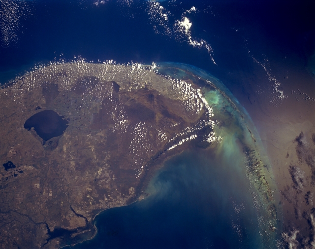
Image Caption: STS052-153-067 South Florida, U.S.A. October 1992
This synoptic, southeast-looking photograph portrays several manmade and natural features--Charlotte Bay (lower left); large, dark Lake Okeechobee, south and southwest of which are large sugarcane fields; the densely populated Miami Gold Coast; shallow Florida Bay; and the southwest-arcing Florida Keys. Extending from the sugarcane fields south of Lake Okeechobee to the southern tip of mainland Florida are The Everglades, an area of extensive swamp, saw grass, and hardwood hammocks. Known as a great "river of grass," The Everglades are an environmentally sensitive region with a delicate balance of water resource usage; many dams and canals constructed south of Lake Okeechobee have altered the natural water flow to the south and southwest.
This synoptic, southeast-looking photograph portrays several manmade and natural features--Charlotte Bay (lower left); large, dark Lake Okeechobee, south and southwest of which are large sugarcane fields; the densely populated Miami Gold Coast; shallow Florida Bay; and the southwest-arcing Florida Keys. Extending from the sugarcane fields south of Lake Okeechobee to the southern tip of mainland Florida are The Everglades, an area of extensive swamp, saw grass, and hardwood hammocks. Known as a great "river of grass," The Everglades are an environmentally sensitive region with a delicate balance of water resource usage; many dams and canals constructed south of Lake Okeechobee have altered the natural water flow to the south and southwest.
