STS052-153-33
| NASA Photo ID | STS052-153-33 |
| Focal Length | 250mm |
| Date taken | 1992.10.25 |
| Time taken | 10:03:32 GMT |
Resolutions offered for this image:
640 x 480 pixels
640 x 480 pixels
Cloud masks available for this image:
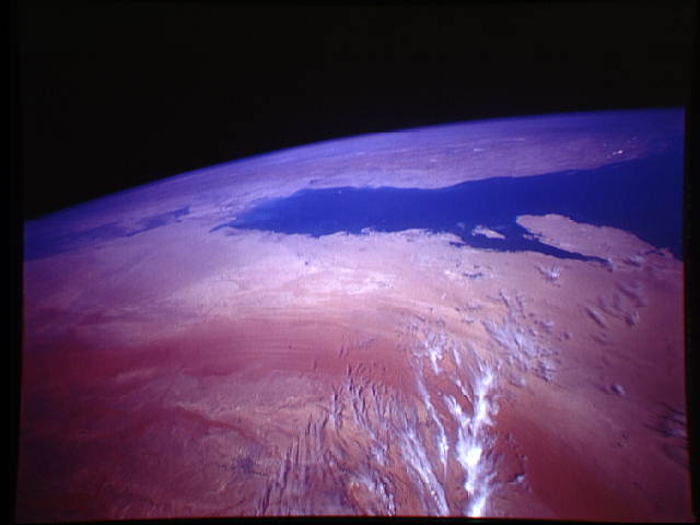
Spacecraft nadir point: 22.3° N, 46.5° E
Photo center point: 28.0° N, 47.0° E
Photo center point by machine learning:
Photo center point: 28.0° N, 47.0° E
Photo center point by machine learning:
Nadir to Photo Center: North
Spacecraft Altitude: 157 nautical miles (291km)
Country or Geographic Name: | SAUDI ARABIA |
Features: | PAN, VIEW NORTH, AN NAFUD |
| Features Found Using Machine Learning: | |
Cloud Cover Percentage: | 20 (11-25)% |
Sun Elevation Angle: | 50° |
Sun Azimuth: | 213° |
Camera: | Linhof |
Focal Length: | 250mm |
Camera Tilt: | High Oblique |
Format: | QX868: Kodak, natural color positive, Ektachrome QX868(5017 emulsion), ASA 64, thin base |
Film Exposure: | Under Exposed |
| Additional Information | |
| Width | Height | Annotated | Cropped | Purpose | Links |
|---|---|---|---|---|---|
| 640 pixels | 480 pixels | No | No | ISD 1 | Download Image |
Download Packaged File
Download a Google Earth KML for this Image
View photo footprint information
Download a GeoTIFF for this photo
Image Caption: This panoramic view of Central Saudi Arabia and the Persian Gulf (28.0N, 47.0E) dramatically illustrates the stark beauty of the deserts. Riyadh, the capital city, lies in the foreground, with the Persian Gulf in the middle and Iran in the background. The coastal oil terminals of Al Hufuf and Ad Dammam are also visible. Black smudges of soot from the oil fires set during the Gulf War can be seen on the sands to the north and south of Kuwait City.
