STS052-152-26
| NASA Photo ID | STS052-152-26 |
| Focal Length | 90mm |
| Date taken | 1992.10.31 |
| Time taken | 08:27:57 GMT |
Resolutions offered for this image:
640 x 480 pixels
640 x 480 pixels
Cloud masks available for this image:
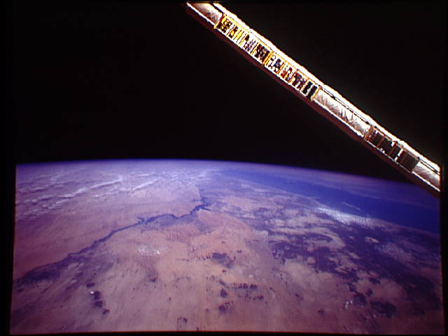
Spacecraft nadir point: 17.9° N, 32.1° E
Photo center point: 22.5° N, 32.0° E
Photo center point by machine learning:
Photo center point: 22.5° N, 32.0° E
Photo center point by machine learning:
Nadir to Photo Center: North
Spacecraft Altitude: 115 nautical miles (213km)
Camera: | Linhof |
Focal Length: | 90mm |
Camera Tilt: | High Oblique |
Format: | QX868: Kodak, natural color positive, Ektachrome QX868(5017 emulsion), ASA 64, thin base |
Film Exposure: | Under Exposed |
| Additional Information | |
| Width | Height | Annotated | Cropped | Purpose | Links |
|---|---|---|---|---|---|
| 640 pixels | 480 pixels | No | No | ISD 1 | Download Image |
Download Packaged File
Download a Google Earth KML for this Image
View photo footprint information
Download a GeoTIFF for this photo
Image Caption: Backdropped over eastern Egypt and Sudan, the Nile Niver and Lake Nasser, (22.5N, 32.0E) the Canadian built remote manipulator system (RMS) displays an array of witness plate material samples for evaluation in space environment. In this view of the Nile River, North Sudan and Lower Egypt, the lifegiving potential of this mighty river that has sustained this region for thousands of years has been enhanced in modern times by the building of Lake Nasser.
