STS052-151-208
| NASA Photo ID | STS052-151-208 |
| Focal Length | 250mm |
| Date taken | 1992.10.24 |
| Time taken | 11:36:43 GMT |
Resolutions offered for this image:
640 x 480 pixels
640 x 480 pixels
Cloud masks available for this image:
Spacecraft nadir point: 14.8° N, 51.0° E
Photo center point: 13.5° N, 48.0° E
Photo center point by machine learning:
Photo center point: 13.5° N, 48.0° E
Photo center point by machine learning:
Nadir to Photo Center: West
Spacecraft Altitude: 156 nautical miles (289km)
Camera: | Linhof |
Focal Length: | 250mm |
Camera Tilt: | 52 degrees |
Format: | QX868: Kodak, natural color positive, Ektachrome QX868(5017 emulsion), ASA 64, thin base |
Film Exposure: | Normal |
| Additional Information | |
| Width | Height | Annotated | Cropped | Purpose | Links |
|---|---|---|---|---|---|
| 640 pixels | 480 pixels | No | No | ISD 1 | Download Image |
Download Packaged File
Download a Google Earth KML for this Image
View photo footprint information
Download a GeoTIFF for this photo
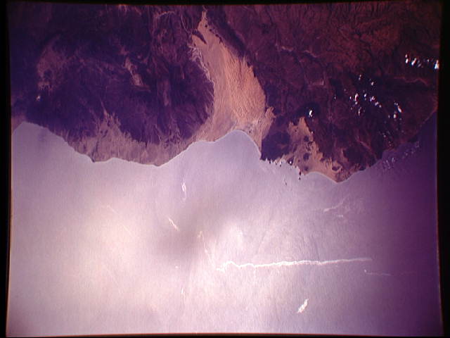
Image Caption: In this view of the Gulf of Aden, and the coast of north Yemen (13.5N, 48.0E) the sunglint pattern clearly delineates oil on the water surface as bright streaks relative to the surrounding water. The oil is most likely the result of oil tanker ships flushing their tanks as they transit the gulf. Once formed, the oil slicks are pushed around by the combined effects of wind and currents as can be seen in the deformations of the long offshore oil streak.
