STS052-151-160
| NASA Photo ID | STS052-151-160 |
| Focal Length | 250mm |
| Date taken | 1992.10.24 |
| Time taken | 11:26:24 GMT |
Resolutions offered for this image:
640 x 480 pixels
640 x 480 pixels
Cloud masks available for this image:
Spacecraft nadir point: 27.3° N, 11.3° E
Photo center point: 27.0° N, 11.0° E
Photo center point by machine learning:
Photo center point: 27.0° N, 11.0° E
Photo center point by machine learning:
Nadir to Photo Center: Southwest
Spacecraft Altitude: 158 nautical miles (293km)
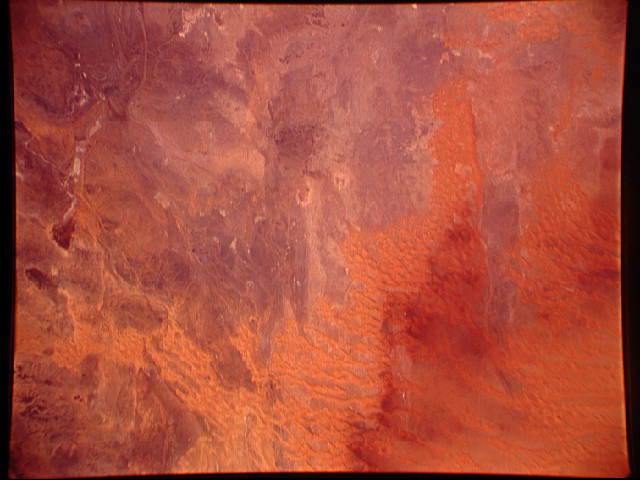
Country or Geographic Name: | LIBYA |
Features: | UBARI SAND SEA, DUNES |
| Features Found Using Machine Learning: | |
Cloud Cover Percentage: | 0 (no clouds present) |
Sun Elevation Angle: | 50° |
Sun Azimuth: | 190° |
Camera: | Linhof |
Focal Length: | 250mm |
Camera Tilt: | 9 degrees |
Format: | QX868: Kodak, natural color positive, Ektachrome QX868(5017 emulsion), ASA 64, thin base |
Film Exposure: | Normal |
| Additional Information | |
| Width | Height | Annotated | Cropped | Purpose | Links |
|---|---|---|---|---|---|
| 640 pixels | 480 pixels | No | No | ISD 1 | Download Image |
Download Packaged File
Download a Google Earth KML for this Image
View photo footprint information
Download a GeoTIFF for this photo
Image Caption: Desert landscapes such as this part of the northern Sahara (27.0N, 11.0E) may be analogous to other planets which have no soil or plant growth. The dark rocks in this view are probably volcanic in origin and have many stream beds leading into the dune areas. These stream beds carry sediments towards the lower terrain where the water evaporates, leaving the sediments to be wind blown into the complex dune patterns. The red color comes from iron oxides.
