STS049-97-54
| NASA Photo ID | STS049-97-54 |
| Focal Length | 250mm |
| Date taken | 1992.05.13 |
| Time taken | 00:54:25 GMT |
Resolutions offered for this image:
3940 x 3962 pixels 636 x 639 pixels 5700 x 6000 pixels 500 x 526 pixels 640 x 480 pixels
3940 x 3962 pixels 636 x 639 pixels 5700 x 6000 pixels 500 x 526 pixels 640 x 480 pixels


Cloud masks available for this image:
Spacecraft nadir point: 7.0° S, 119.4° E
Photo center point: 8.0° S, 118.0° E
Photo center point by machine learning:
Photo center point: 8.0° S, 118.0° E
Photo center point by machine learning:
Nadir to Photo Center: Southwest
Spacecraft Altitude: 198 nautical miles (367km)
Country or Geographic Name: | INDONESIA |
Features: | SUMBAWA, TAMBORO VOLCANO |
| Features Found Using Machine Learning: | |
Cloud Cover Percentage: | 5 (1-10)% |
Sun Elevation Angle: | 38° |
Sun Azimuth: | 60° |
Camera: | Hasselblad |
Focal Length: | 250mm |
Camera Tilt: | 28 degrees |
Format: | 5017: Kodak, natural color positive, Ektachrome, X Professional, ASA 64, standard base |
Film Exposure: | Normal |
| Additional Information | |
| Width | Height | Annotated | Cropped | Purpose | Links |
|---|---|---|---|---|---|
| 3940 pixels | 3962 pixels | No | No | Earth From Space collection | Download Image |
| 636 pixels | 639 pixels | No | No | Earth From Space collection | Download Image |
| 5700 pixels | 6000 pixels | No | No | Download Image | |
| 500 pixels | 526 pixels | No | No | Download Image | |
| 640 pixels | 480 pixels | No | No | Download Image |
Download Packaged File
Download a Google Earth KML for this Image
View photo footprint information
Download a GeoTIFF for this photo
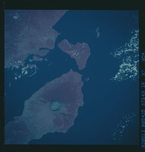
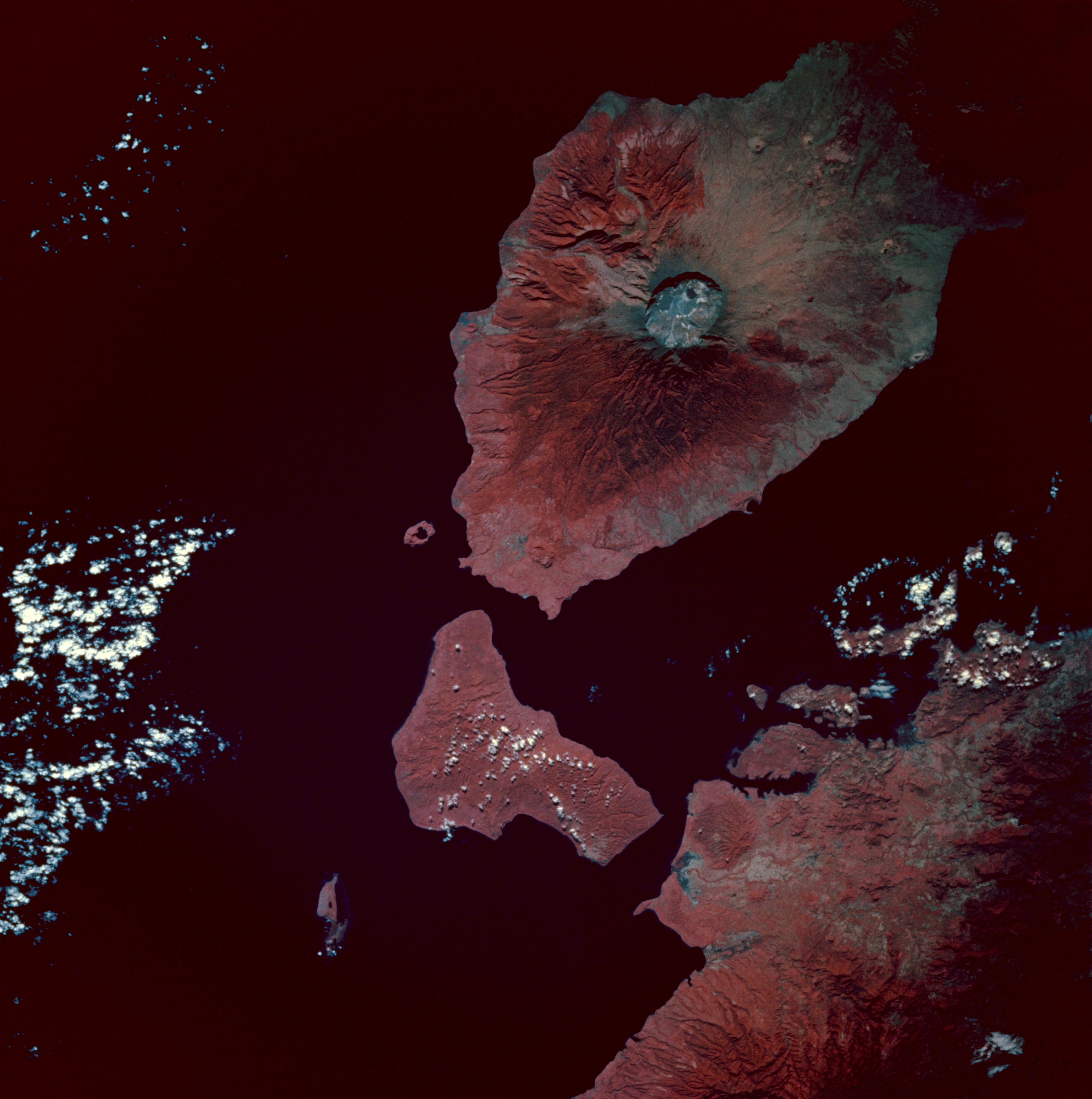
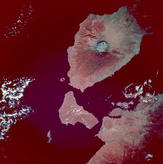
Image Caption: STS049-97-54 Tambora Volcano, Sumbawa Island, Indonesia May 1992
The most striking geologic feature in this photograph is the large circular Tambora Volcano caldera, the diameter of which is slightly more than 3 miles (5 kilometers). Prior to the disastrous eruption of 1815 when the volcano blew away most of its top, Tambora's summit was approximately 13 000 feet (4000 meters) above sea level. The present elevation of the caldera rim is more than 9000 feet (2700 meters) above sea level. Many geologists and volcanologists rank the 1815 eruption among the 10 most explosive eruptions of the modern era. Tambora, a classic stratovolcano with steep slopes and a symmetrical shape, is located on the north-central coast of Sumbawa Island, Indonesia, which is bordered on the north by the Flores Sea and on the southwest by Teluk Saleh Bay. Color infrared film, which displays green vegetation in varying shades of red, accentuates the distribution patterns of dense tropical vegetation surrounding the volcano and other land areas in the photograph.
The most striking geologic feature in this photograph is the large circular Tambora Volcano caldera, the diameter of which is slightly more than 3 miles (5 kilometers). Prior to the disastrous eruption of 1815 when the volcano blew away most of its top, Tambora's summit was approximately 13 000 feet (4000 meters) above sea level. The present elevation of the caldera rim is more than 9000 feet (2700 meters) above sea level. Many geologists and volcanologists rank the 1815 eruption among the 10 most explosive eruptions of the modern era. Tambora, a classic stratovolcano with steep slopes and a symmetrical shape, is located on the north-central coast of Sumbawa Island, Indonesia, which is bordered on the north by the Flores Sea and on the southwest by Teluk Saleh Bay. Color infrared film, which displays green vegetation in varying shades of red, accentuates the distribution patterns of dense tropical vegetation surrounding the volcano and other land areas in the photograph.
