STS049-96-62
| NASA Photo ID | STS049-96-62 |
| Focal Length | 250mm |
| Date taken | 1992.05.16 |
| Time taken | 02:17:33 GMT |


Cloud masks available for this image:
Spacecraft nadir point: 15.6° N, 117.6° E
Photo center point: 16.0° N, 119.0° E
Photo center point by machine learning:
Photo center point: 16.0° N, 119.0° E
Photo center point by machine learning:
Nadir to Photo Center: East
Spacecraft Altitude: 192 nautical miles (356km)
Country or Geographic Name: | PHILIPPINES |
Features: | SHIP WAKES, OIL SLICK |
| Features Found Using Machine Learning: | |
Cloud Cover Percentage: | 30 (26-50)% |
Sun Elevation Angle: | 64° |
Sun Azimuth: | 78° |
Camera: | Hasselblad |
Focal Length: | 250mm |
Camera Tilt: | 24 degrees |
Format: | 5017: Kodak, natural color positive, Ektachrome, X Professional, ASA 64, standard base |
Film Exposure: | Under Exposed |
| Additional Information | |
| Width | Height | Annotated | Cropped | Purpose | Links |
|---|---|---|---|---|---|
| 5700 pixels | 6000 pixels | No | No | Download Image | |
| 500 pixels | 526 pixels | No | No | Download Image | |
| 640 pixels | 480 pixels | No | No | Download Image |
Download Packaged File
Download a Google Earth KML for this Image
View photo footprint information
Download a GeoTIFF for this photo
Image Caption:
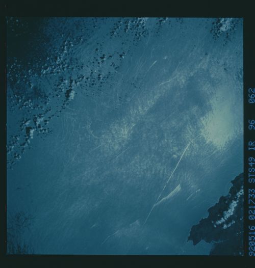
STS49-96-062: S. China Sea: Ship Wakes and Oil Slicks As in the
previous slide, this view of sunglint in the South China Sea
shows an oil slick resulting from ship bilge pumping along the
coast of the Philippine island of Luzon. The interesting aspect
of this slick is the braided pattern that appears to grow and
develop with distance from the ship, which is seen at the bottom
of the photo.
